Lower Palaeozoic rocks of the Craven Inliers
Eric Johnson formerly British Geological Survey
Purpose
To examine the stratigraphy and structure of the Ordovician and Silurian rocks, the Sub-Carboniferous unconformity, features of the Pleistocene glaciation, and economic geology.
Logistics
Three half-day excursions, mostly on public rights of way, in the three valleys where Lower Palaeozoic rocks are exposed: Chapel le Dale, Crummack Dale and Ribblesdale. There are car parks, toilets and services in Ingleton, Clapham, Stainforth and Horton in Ribblesdale.
Note Access to Arcow Quarry must be agreed with the quarry manager beforehand (Tel: 01729 860202) and will require safety helmets, protective footwear and insurance cover.
Maps
O.S. 1:50 000 Sheet 98 Wensleydale & Wharfedale; 1:25 000 Outdoor Leisure Map 2, Yorkshire Dales (Western area); B.G.S. 1:50 000 Sheet 50 Hawes; and Sheet 60 Settle.
B.G.S. Memoir, Settle (Arthurton et al., 1988).
Geological background
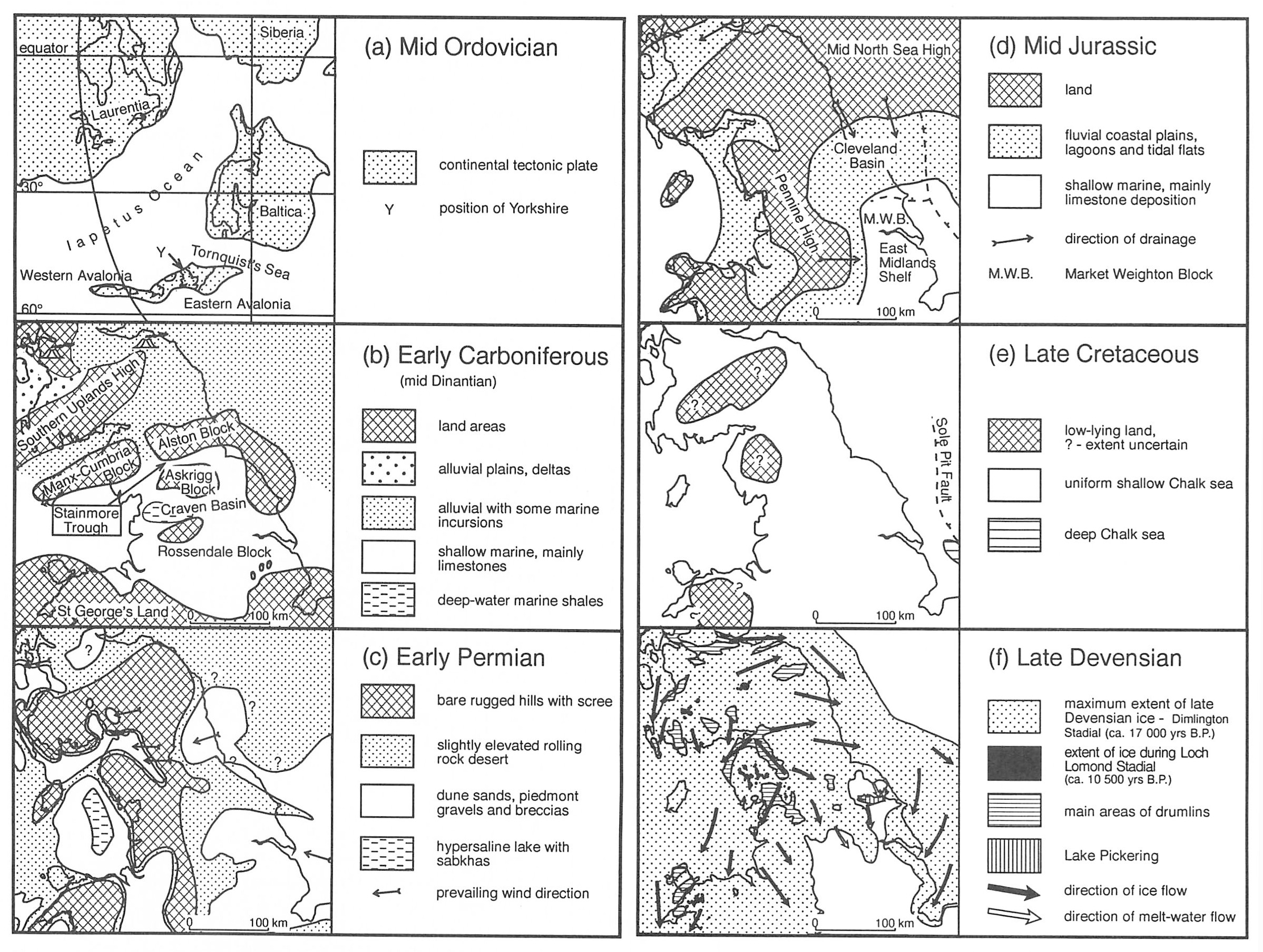
The Craven Inliers are found on the southern margin of the Askrigg Block, immediately north of the North Craven Fault
The oldest,
The group was deformed and uplifted as Iapetus Ocean crust began to be subducted in the Early Ordovician. By the Late Llanvirn continued uplift resulted in the folded and cleaved rocks forming an island arc with subduction related volcanism. Subaerial volcanic rocks are preserved in the Lake District, but no Late Llanvirn or Caradoc rocks are present in the Craven Inliers.
Subsidence caused the island arc topography to be transgressed by an Ashgill sea. The upper Ordovician, a mixed carbonate clastic shelf sequence, rests unconformably on the
In the Wenlock, turbidite sandstones (
The collision of Eastern Avalonia, Laurentia and Baltica produced folds, cleavage and minor thrusts in the early Devonian Acadian Orogeny. Granite plutons, generated at depth, were emplaced into the deformed sedimentary rocks that formed a continental fold mountain belt during the remainder of the Devonian. Crustal stretching early in the Carboniferous produced a series of rift basins and blocks across the British Isles. The Lower Palaeozoic rocks form part of the buoyant Askrigg Block, underpinned by the Wensleydale Granite. The Craven Faults define the southern margin of the block and separate it from the Craven (rift) Basin. The relief of the continental area gradually declined and subsidence during crustal stretching allowed the tropical Carboniferous seas to slowly transgress across the rifted Lower Palaeozoic terrain.
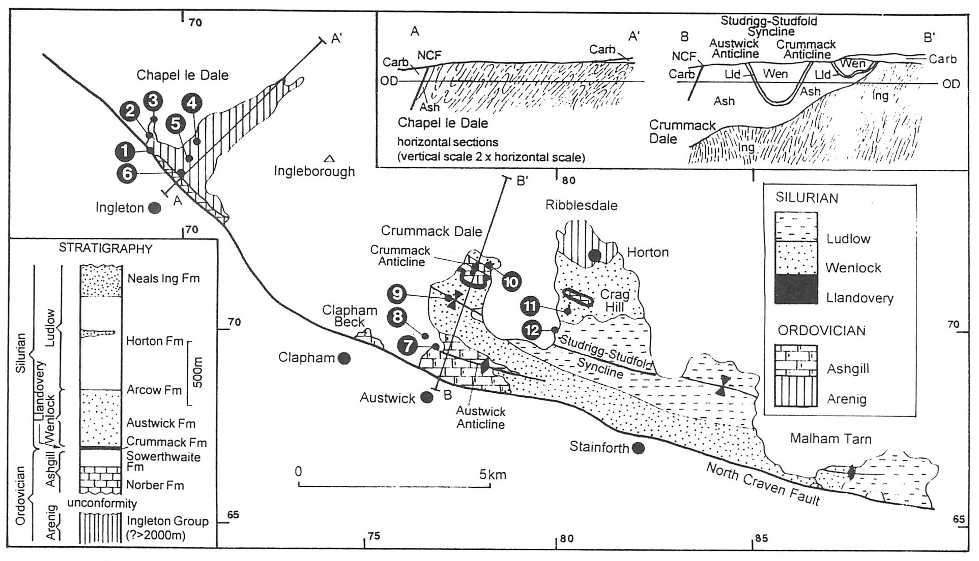
Excursion details
The stratigraphic names used are those on the Settle 1:50 000 geological map and in the accompanying memoir (Arthurton et al., 1988).
Ingleton, Kingsdale and Chapel le Dale
Begin in the car park on the west side of the River Twiss
The
Locality 1, Swilla Glen
Follow the footpath that leads north from the car park on the alluvial flat that overlies Coal Measures rocks on the downthrow side of the South Craven Fault. The fault is crossed at
The River Twiss follows the fault line for a short distance near Manor Bridge
Locality 2, Pecca Falls and Quarry
Cross Pecca Bridge
At the first viewpoint to Pecca
A synclinal axis is present immediately above the waterfall. A further 60 m along the path thick sandstone beds with laminated tops and siltstone interbeds dip 30–40° southwards and towards Thornton Force the dip gradually steepens.
Locality 3, Thornton Force (see cover photograph )
The path continues on the
Continue on the path over limestone via Twisleton Hall towards the River Doe. Exposures of turbidite sandstone are seen near Beezleys.
Locality 4, Beezley Falls
The falls are in subvertical
Locality 5, Snow Falls
The cleaved siltstones of the
Locality 6, Twisleton Glen
The
Continue on the footpath to return to the car park in Ingleton. In Meal Bank Quarry
Crummack Dale
Begin at the Crummack and Thwaite Lane crossroad
The excursion examines stratigraphy and structure of the Ashgill to Wenlock parts of the Windermere Group, the Sub-Carboniferous unconformity, and effects of the Pleistocene glaciation
Locality 7, Nappa Scars [SD 768 697]
The footpath 50 m west of the crossroads leads to Nappa Scars where the Sub-Carboniferous unconformity is exposed. Pebbly limestone and conglomerate onlap a palaeocliff in cleaved calcareous siltstone of the Upper Ordovician (Ashgill)
The prominent planes in the calcareous siltstone that dip 60–70° south-southwest are the Acadian cleavage. Bedding is ill-defined but a few laminae dip northwards at about 40°. A sparse brachiopod and trilobite fauna indicates the Rawtheyan Stage of the Ashgill.
The unconformity lies in the undercut part of the cliff. The basal few metres of the Carboniferous consist of clast-supported boulder beds and conglomerate. Many of the larger boulders are
On the cliff top look east-southeast, along the prominent scarp of Norber Brow, an exhumed palaeocliff, its form today closely resembling that in Carboniferous times. The limestones abut and eventually onlap the cliff, indicating the marine transgression onto the irregular topography of the Askrigg Block. Return to the stile at
Locality 8, Norber [SD 767 700]
The limestone pavement is strewn with blocks of dark
Again return to the stile at
Locality 9, Central Crummack Dale [SD 773 708]
Follow the footpath northeast for 250 m, to where it crosses a stream that is coincident with the axis of the Studrigg–Studfold Syncline. Look west-northwest towards the unconformity on the west side of the valley, up the plunge direction of the fold; the strike of the sandstone beds (
Locality 10, Moughton Whetstone Hole [SD 784 719]
Where the footpath leaves the enclosed farmland is Moughton Whetstone Hole. Adjacent to the stream, the ground is littered with fragments of dark red and green banded rock, the remnants of a bygone enterprise that worked the
Return down the lane towards Wharfe. Southward-dipping
Northward-dipping rocks can be seen next to the ford in Austwick Beck where Silurian 'flags' have been used to construct a clapper bridge. The lane to Wharfe follows the foot of the escarpment formed by northward-dipping
Ribblesdale
Younger parts of the Silurian succession are preserved in Ribblesdale because the main synclinal axis plunges east-southeast.
The stratigraphy, sedimentology and structure of the Wenlock and Ludlow parts of the Windermere Group and the Sub-Carboniferous unconformity are superby exposed in two quarries less than 1 km apart
Locality 11, Arcow Quarry [SD 802 705]
Access to the quarry should have been arranged beforehand (see logistics).
The roadstone quarry is in the Austwick, Arcow and Horton Formations on the southward-dipping, northern limb of the StudriggStudfold Syncline. The structure is most clearly seen from the east side ofthe quarry
On the north side there is an east-southeast plunging anticline, a parasitic fold on the limb of the main syncline. The anticline and most of the quarry are in the
The sandstone units consist of parallel-bedded fine to medium grained turbidites up to 2 m thick. Some of the thicker beds have coarse bases, consisting of ill-sorted quartz, feldspar and rock fragments with a clay matrix. Sole structures, mostly flute casts, on the base of some beds indicate turbidity currents flowing from an east-southeast direction. Ripple marks on the top of the sandstones, however, show current reworking from the west-southwest. The sandstones pass gradationally upwards into overlying dark-grey, parallel-laminated siltstones containing a few thin mudstone and siltstone turbidites. Graptolites of Wenlock age are present. Approximately 20 m of siltstone separate the youngest sandstone unit from the overlying Arcow Formation.
The Arcow Formation comprises 9 m of medium to light-grey, weakly bedded, calcareous siltstone. The basal metre is thin bedded and some beds are ripple cross-laminated. Extensive bioturbation has destroyed most of the bedding. It contains a sparse shelly fauna dominated by orthocones. Benthonic fauna and bioturbation indicate an oxygenated depositional environment, contrasting with anoxic conditions for the beds above and below. There is a 2 m gradational passage into the overlying Horton Formation.
The Horton Formation consists of dark-grey, parallel-laminated siltstone that is sandy and calcareous in part. Calcareous nodules occur near the base, often in layers. Only the oldest part of the 700 m thick succession, with poorly preserved Ludlow graptolites, is exposed in the quarry.
Locality 12, Combs Quarry, Foredale [SD 800 701]
Follow the road from Foredale to the terrace of cottages on the hillside above. A path leads to the quarry.
The quarry worked the dark-grey, laminated siltstone of the Horton Formation for flagstones. The siltstones dip steeply south and are lithologically similar to those in Arcow Quarry. Thin interbeds of bentonite (off-white volcanic clay from large, distant, subaerial eruptions) are present in the siltstone succession. They are much softer than the siltstone, forming recesses and prominent bedding planes. The Sub-Carboniferous unconformity is exposed at the top of the quarry face; bedding in the Carboniferous limestone above is subhorizontal.