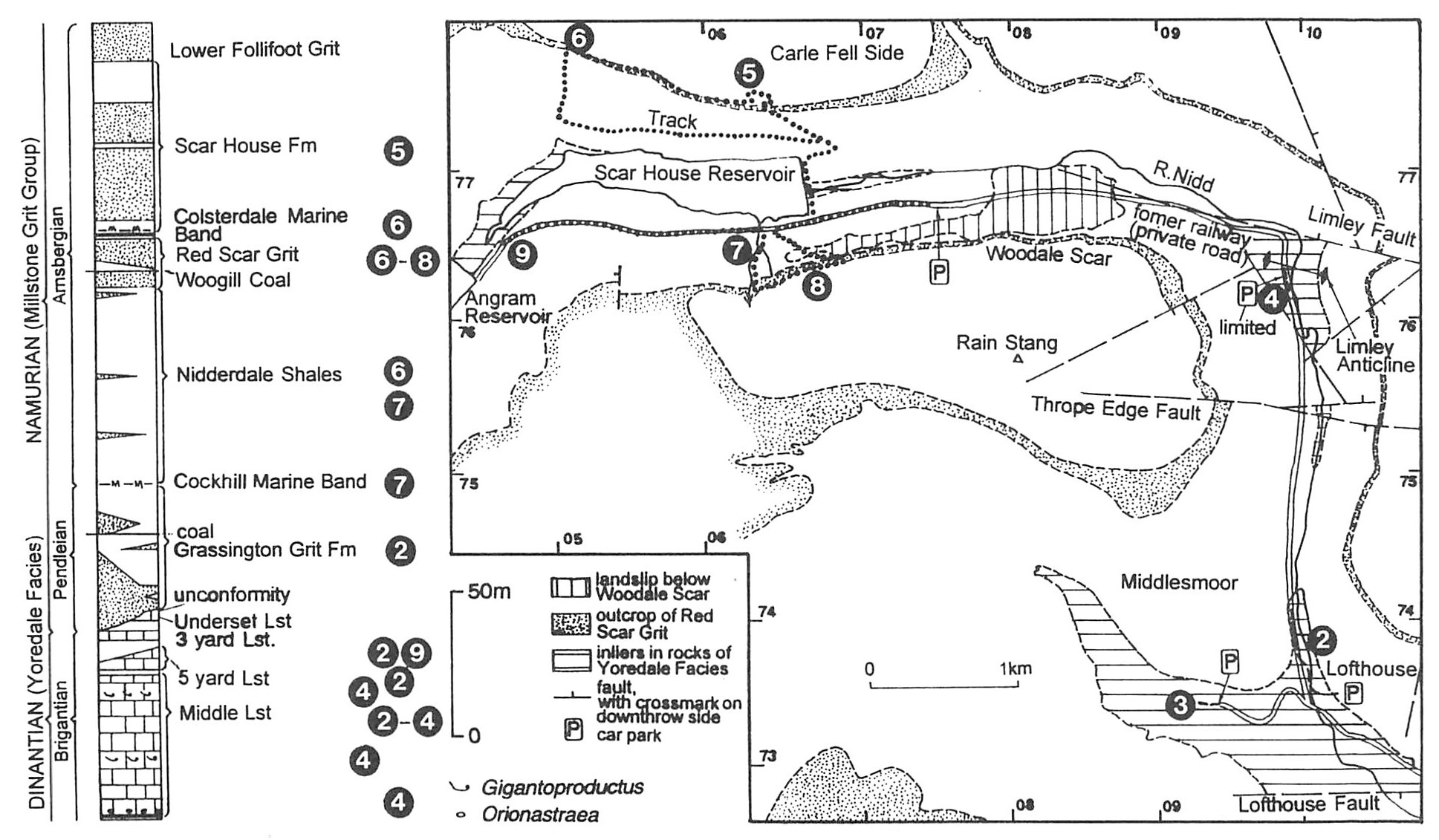
5 The Carboniferous rocks of upper Nidderdale
Albert Wilson past President, Yorkshire Geological Society
Purpose
To examine rocks of the Millstone Grit Group (Namurian) and underlying limestones of late Dinantian age.
Logistics
A one-day excursion in two parts requiring transport by car. Part (Locality 1) is at Brimham Rocks, southeast of Pateley Bridge. Part 2 (Localities 2–9) is in Upper Nidderdale, above Lofthouse, beyond which there are no shops or inns. Information about food and toilet facilities is given in the itinerary.
The area around Scar House (Localities 5–9) is owned by Yorkshire Water. A permit must be sought in advance for groups of more than eight people to visit this area from Mr R. Baxter, Yorkshire Water, Western House, Western Way, Halifax Road, Bradford, BD6 2LZ. Ample notice, a minimum of three weeks, should be given for the permit. There is a further restriction on Locality 5: access is only possible from August till February inclusive.
Note: Safety helmets should be worn in the quarry at Locality 5.
Maps
O.S. 1:50 000 Sheet 99 Northallerton & Ripon; B.G.S. 1:50 000 Sheet 51 Masham.
Geological background
Upper Nidderdale lies in the southeastern part of the Askrigg Block, an area of Carboniferous strata gently tilted towards the east. A local fold is seen near Limley
Quarries in upper Nidderdale have furnished much of the stone for the three large reservoir dams built to supply Bradford and now managed by Yorkshire Water. The specific weathering characteristics of the gritstone are well seen at Brimham Rocks, and of the
Excursion details
Start the excursion at Brimham Rocks. Approach via a southward turning on the B6265 Pateley Bridge–Ripon road
Locality 1, Brimham Rocks [SE 208 646]
The spectacular natural cliffs and tors of Brimham Rocks are carved out of a plateau of
From the car parks, follow paths along the west-facing craggy escarpment in coarse and very coarse-grained feldspathic sandstone. The cliffs show many c.1 m units of cross-bedded sandstone deposited in fast-flowing delta channels of a river system originating in northern Scotland and Norway. Fretted shapes due to differential cementation can be seen, as well as scattered quartz pebbles. At the visitor centre, Brimham Lodge, built in 1792 as a shooting lodge for Lord Grantley, a video presentation on the rocks can be viewed. Refreshments and toilets are available nearby.
Follow the footpath on the north side of Brimham Lodge towards the east. Some of the more bizarre rock shapes are seen here in the 19 m thick grit. The Idol is an in situ part of the bedrock with a massive top and a tiny plinth. The greatly undercut base may owe its formation partly to wind erosion after the Devensian glaciation. The Druid's Writing Desk is a mushroom-shaped stone on the escarpment edge. The many tors, like the Dancing Bear, were probably shaped in part by freeze-thaw acting on joints in the grit just after the Devensian glaciation. Return to the car parks past Middle Crags, where further tors with fretted bedding can be seen.
Return via the B6265 to Pateley Bridge, where the Nidderdale Museum may be visited (see p. 203). Drive northwards from Pateley Bridge to Lofthouse, turning right into the village (public car park on the right).
Locality 2, Lofthouse [SE 1005 7358]
Immediately uphill take a path from the left side of the road to a footbridge over the River Nidd. Exposures in
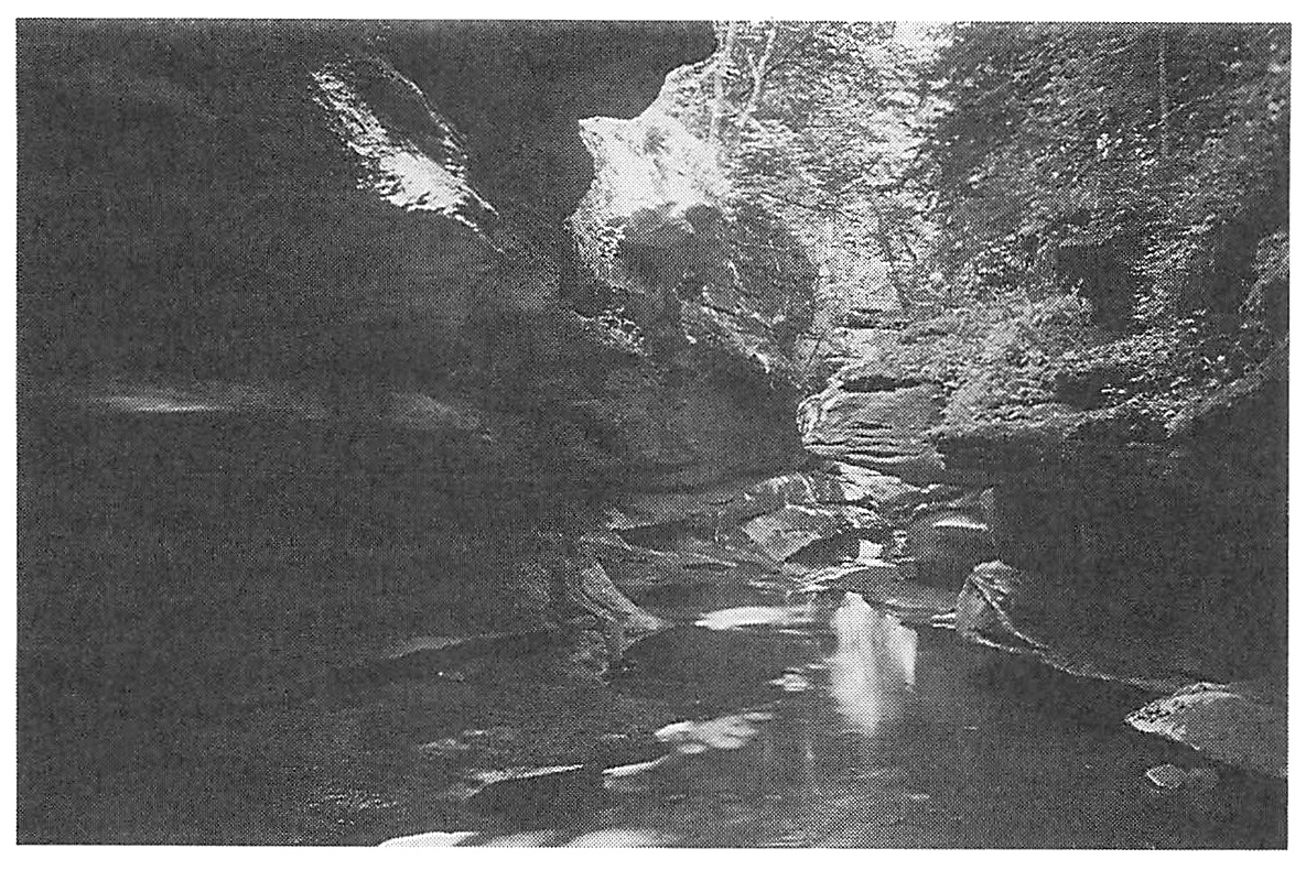
Locality 3, How Stean Gorge [SE 094 735]
Turn right towards Middlesmoor at the junction at the foot of Lofthouse village. A left turn to How Stean Gorge and caves is signposted. There is an admission charge. The feature of interest is a deep gorge with safe walkways for viewing the deeply fretted cliffs in the upper beds of the
Locality 4, [SE 0992 7647]
Rejoin the road and turn right briefly, before turning left up the private road to Upper Nidderdale. En route, look right to view the landslip of Thrope Edge, with a steep back scar. Continue northwards past a limestone cliff to the portal of an old railway tunnel, where there is parking
Descend directly eastwards through the stiles to the River Nidd where the base of the
Return to the tunnel mouth where in cliffs to the south the greater part of the
Rejoin the cars and drive up the Nidd Valley almost to Scar House Dam. Park in the visitor car park on the south side of the valley.
Locality 5, Carle Side Quarries [SE 063 776]
Walk across the dam to the north side and ascend the old incline to Carle Side Quarries (access restricted to August till February inclusive). The three levels of the quarries were developed in 1920–34 to provide stone for the construction of Scar House Dam, which has a concrete core and masonry face. The dam trench was excavated in the highest Yoredale strata and the Grassington Grit Formation. In their heyday the quarries employed 400 men. Looking southwards, another old quarry visible on Rain Stang was open in 1904–15 to provide stone for the Angram Dam, farther up the valley. Note the great landslip of Woodale Scar beneath this quarry, formed by freeze-thaw at the close of the Devensian glaciation. Also one can see the dramatic right-angled bend of the Nidd 4 km to the east. This may mark the point of capture of the eastward-flowing proto-Nidd by a southward-flowing stream.
The lower sandstones of the Scar House Formation in the quarries at Carle Side were deposited by voluminous density currents beyond the mouth bar of a river. These are followed on the second level of the quarry by prodelta sand lobes with flute marks on some bedding planes, shown well in fallen blocks from above a bush high on the face. Ascend the dumps to the highest quarry level where medium-grained channel sandstones are displayed. At the undulating base of the higher channel a conglomerate with abundant siltstone rip-up clasts is well seen. Higher strata are thinly bedded mouth bar sandstones, overlain by mudstones. The skyline feature is in
Traverse the hillside westwards from the highest quarry levels along the top of the feature in the
Locality 6, Stand Syke [SE 0509 7784]
Here, traces of the Woogill Coal, named after the next major stream east of Carle Side quarries, can be seen in the grit. It has been extensively worked by adits and some shafts in Colsterdale to the north, ever since the days of Fountains Abbey. Much of the
Locality 7, The stream 50 m east of Scar House Gill [SE 0638 7654]
The stream 50 m east of Scar House Gill
Cross westwards into Scar House Gill, where the marine band is less well exposed but includes the nodular limestone with goniatites. The overlying Nidderdale Shales consist of 72 m of almost continuously exposed mudstones with a few thin bands of fine-grained sandstone. There are no seatearth bands and fossils are scattered plant debris. Above, the
Locality 8, [SE 0680 7737]
Traverse eastwards along the lip of Nidderdale for 600 m with a fine view across the valley to Carle Side quarries. On the horizon to the north are two outliers in
Where the track to Middlesmoor intersects the traverse, the two leaves of the
Look upwards to the scar in the lower leaf of the
Locality 9 [SE 046 766]
Walk along the road towards Angram Reservoir (cars are not permitted along this stretch) and descend to the south bank of Scar House Reservoir, 300 m down-valley from the Angram Dam. Care is needed, because the exposure is close to the bank of Scar House Reservoir. The sequence consists of 3 m of fossiliferous shaly mudstones with siderite nodules, overlain by 5.4 m of unfossiliferous shaly mudstones, capped by 3.6 m of Three
Return to the car park, with views along the road of Scar House Dam, the great landslips below Woodale Scar and finally the major bend in the River Nidd 4 km downstream.