18 Lower and Middle Jurassic rocks between Robin Hood's Bay and Hawsker Bottoms
John Senior formerly Durham University
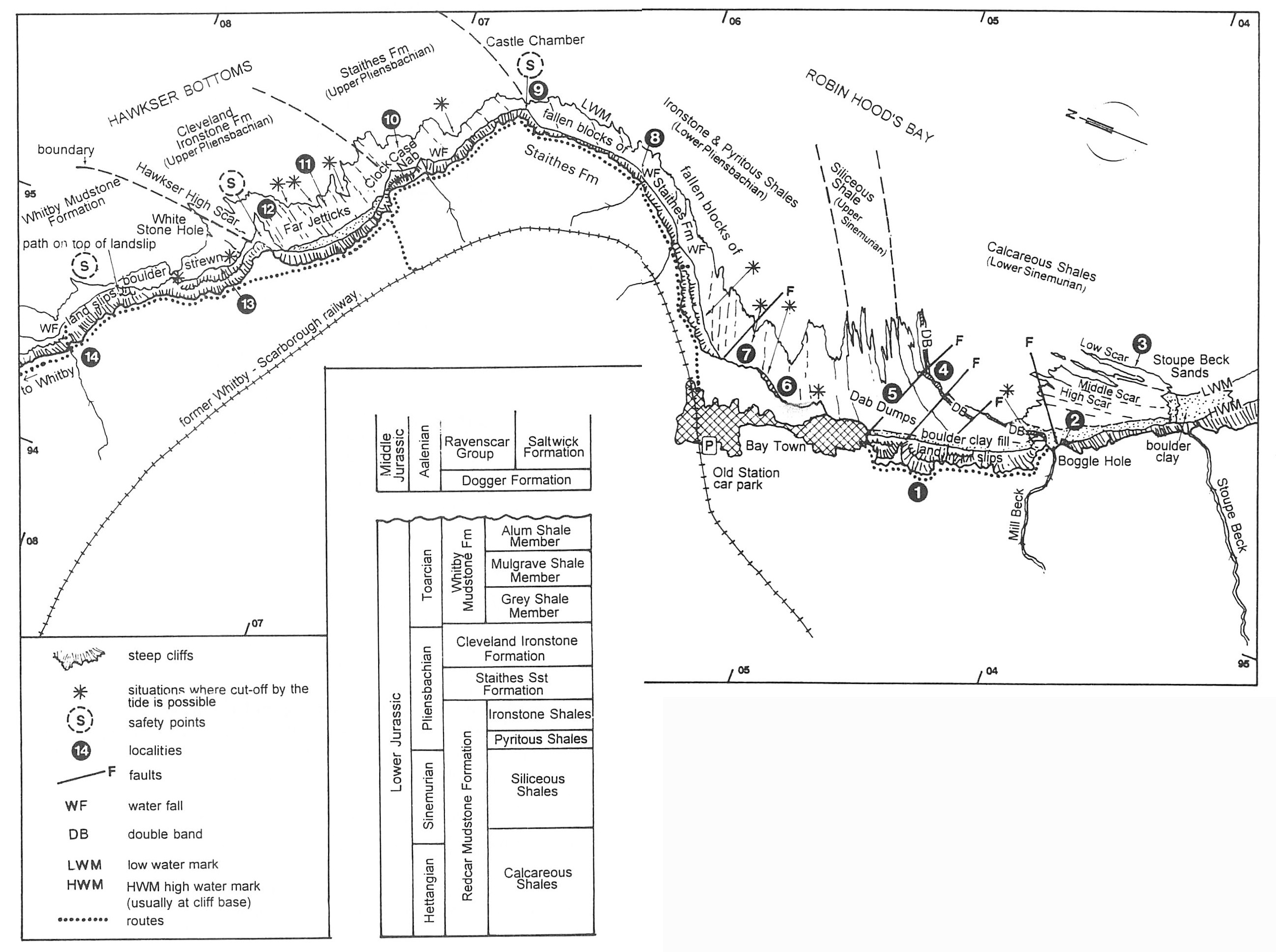
Purpose
To view one of the finest Lower Jurassic sections in Northern Europe, starting with the
Logistics
This is quite a strenuous day, entirely dependent on favourable tides. Park in the Old Station car park in Robin Hood's Bay
There are toilets, pubs and cafes in Bay Town, but none en route.
Note: The beach traverse takes at least 4 hours to complete at a moderate pace for a fit person and with few stops. Start on a falling tide (2–3 hours below low tide). Do not attempt this section at the wrong state of tide with an on-shore wind as there are many places (marked on the sketch map) where the tide rushes in and you could be cut off. The ascent up the cliff at the end of the section at Hawsker Bottoms is very difficult. The cliff is still negotiable, although a difficult scramble (sometimes aided by an in situ rope). Consider this carefully before embarking on the section past Castle Chamber.
Wear a safety helmet. Try to keep clear of the cliffs as there is a constant rain of debris (from shale fragments to sandstone blocks of many tonnes weight). Try to go in pairs so that one can watch the cliff while the other looks at the geology; indeed this is a lonely section so inform someone (i.e. Coastal Wardens) where you are going and at what time you intend returning to Robin Hood's Bay.
At the end of the section when you have ascended the very steep cliff path at Hawsker Bottoms, there is a brisk cliff-top walk of at least 1 hour's duration back to Robin Hood's Bay.
Maps
O.S. 1:50 000 Sheet 94 Whitby; O.S. 1:63 360 Tourist Map North York Moors; B.G.S. 1:63 360 Sheets 35 & 44 Whitby & Scalby.
Geological background
This 11.5 km section is on the northern limb of the Robin Hood's Bay dome structure, one of several inversion structures (intra-Jurassic) found in the Cleveland–Sole Pit Trough Depositional Basin (Kent in Rayner & Hemingway, 1974)
This well-defined and classically exposed equidimensional structure
The base of the Lias (Hettangian Stage) is not exposed even at the lowest tides in Robin Hood's Bay and there may be some slight discrepancy in the actual thicknesses of the lower Liassic sequences which are exposed on the extensive wave-cut platform. A summary geological succession is given in
There are thick deposits of tills in the central areas of Robin Hood's Bay and it has been suggested that these Late Quaternary deposits infill valley features at two points: The Sands, just South of Bay Town
Indeed the base of the pre-glacial valley at Stoupe Beck seems to be below present sea level. These tills contain erratics from a variety of sources and supply exotic beach pebbles in the central section of the Bay (identifying them provides an interesting pastime when waiting for the tide to go out!). The cliffs predominantly composed of till are unstable and subject to extensive landslips but occasionally the tills can be seen to be divided by a central sandy sequence.
Excursion details
From the Old Station car park
Locality 1 [NZ 952 046]
There are fine views from the path of the minor faults exposed on the beach (at Locality 4) which radiate from the centre of the bay and the dome structure.
Locality 2 [NZ 956 041]
At the exit of Mill Beck onto the beach at Boggle Hole identify the 'Double Band' which forms a prominent scar feature to the south of the beck at the base of the cliff. This Double Band forms a prominent marker horizon within the oxynotum Biozone (Sinemurian).
Locality 3 [NZ 959 038]
Walk out into the centre of the bay to the limit of the tide and then work back up-sequence over the harder continuous scars (beach features of calcareous siltstones, fine sandstones and nodule horizons) with intervening softer siltstones and shales (also with nodules) which constitute the Calcareous Shales (lower
At some levels within the softer shales and siltstones large, isolated, flat, subcircular, iron-rich, concretions can be seen. These are usually highly bioturbated and sometimes contain Pentacrinites, belemnites and ammonites. These have been interpreted as 'scours', where bottom currents winnowed out the finer material leaving marginally coarser-grained sediments and shell debris behind, which then attracted iron diagenesis. These 'scours' form a sporadic but integral part of the entire section to be viewed for the rest of the day up to the top of the
Return to the Double Band at the base of the cliff at Boggle Hole and follow this prominent beach feature across Mill Beck (where it is displaced slightly at a small northeast–southwest fault).
Locality 4, Dab Dumps [NZ 956 047]
Around the foreshore between Boggle Hole and Bay Town (known as Dab Dumps) there are a series of small faults associated with the dome structure of Robin Hood's Bay. The throw on these faults can be illustrated using the Double Band as the datum horizon on the foreshore.
Locality 5 [NZ 955 048]
The sediments above the Double Band contain the ammonite Echioceras indicative of the raricostatum Biozone. These form the upper parts of the Siliceous Shales.
Opposite the slipway at Bay Town, rare ammonites in the shales of Ground Wyke Hole indicate the start of the Ironstone/Pyritous Shales (Lower Pliensbachian). All ten subzones of the Lower Pliensbachian have been determined in the Ironstone/Pyritous Shales on the north side of Robin Hood's Bay between Bay Town and Castle Chamber. Ammonites are sporadic and poorly preserved in these sediments (which are characteristically cyclic shale-silt units with prominent ironstone concretion levels) but the genera Acanthopleuroceras, Apoderoceras, Platypleuroceras, Tropidoceras and Androgynoceras are represented. Most of the beds also contain a variety of bivalves, belemnites, brachiopods and wood debris; they are also very bioturbated, commonly with Chondrites, but also with Rhizocorallium, Ophiomorpha and Teichichnus.
Locality 6 [NZ 953 052]
From this point (where curious vertical 'starlike' pyrite bodies may be seen in the shales) onwards, the sediments of the ibex Biozone are rich in the large bivalve Pinna. Over beds some 26.5 m thick the communities of Pinna can be seen either in life position, with the open aperture probably facing the predominant bottom current direction (the planed-off bivalve shells having a distinctive lozenge appearance), or with the large triangular shells current sorted and lying parallel to the bedding planes (storm redistribution?).
Locality 7 [NZ 954 054]
Throughout the remaining part of this section almost to Castle Chamber, horizons of red sideritic nodules are well displayed in cliffs and on the foreshore where they often display a ramifying and connected appearance. These ironstone nodules usually have septarian centres. A prominent nodule horizon may be seen at the base of the cliff with diffused reddish margins and cream-coloured septarian interiors. This is near a prominent normal fault (you might like to pause and try to work out the throw on this fault).
Working northeast towards Ness Point (North Cheek) the slight northern dip on the northern limb of the Robin Hood's Bay dome brings in younger horizons. There are rare ammonites in this part of the section (in nodules and as pyritic nuclei in shales/siltstones), bivalves are common (i.e. Pseudopecten, Pleuromya and other myids and Gyphaea) and there are at least three thin and impersistent limestone horizons comprised of current sorted Gryphaea shells (mixed with belemnites and other bivalves). Cliff exposures near Dungeon Hole
Locality 8 [NZ 960 061]
Just past the waterfall and shipwreck remains at Ness Point and just in view ofCastle Chamber, look for a particular ironstone nodule bed on the foreshore. This 0.10 m thick composite bed of sideritic nodules has large subvertical burrows in the top, filled with chamositic oolitic ironstone (the first oolitic ironstone in the Yorkshire Jurassic Basin). Some 9 m above this oolitic horizon is one ofseveral curious ironstone horizons; this one is bimodal in origin with small concretions (0.10 m in diameter) at the top of a 0.20 m concretionary bed.
From Ness Point on to Castle Chamber large fallen blocks of sandstone from the Staithes Formation may be seen on the foreshore. The stratigraphical top of these blocks often have rippled surfaces and are covered with well-preserved shell debris, including Pseudopecten,
Locality 9, Castle Chamber [NZ 960 067]
The Ironstone Shales (shales/siltstones) at the top of the
Walking northwest towards Clock Case Nab, you will pass over shallow water sediments, particularly sandstones with nests of
Locality 10, Clock Case Nab [NZ 956 071]
A thin split ironstone nodule horizon can be seen at the base of Clock Case Nab. Looking northwest across the embayment called Far Jetticks towards Hawsker High Cliff and High Scar, there is a fine view of the upper Middle Lias (spinatum Biozone) on the foreshore section with a thick sequence of the Upper Lias (
Locality 11, Far Jetticks [NZ 953 073]
The Upper Middle Lias section at Far Jetticks, some 12.5 m thick, may be compared with that seen in the Staithes–Port Mulgrave section (Excursion 16). All the subzone index ammonites may be found on this section together with many belemnites, bivalves and nests of Tetrarhynchia.
While in the vicinity of Hawsker High Cliff look (with extreme caution) at the fallen material at the base of the cliff. Pyrite-skinned nodules contain Harpoceras exaratum and H. falciferum (index fossils of the
Locality 12, Hawsker High Scar [NZ 951 077]
The calcareous sandstone that forms the top of the scar, which may involve a 3 m scramble, is some 3.20 m below the top of the Middle Lias. The sediments here indicate an important event boundary within the Yorkshire Basin, where the shallow-water sediments of the
Locality 13, White Stone Hole [NZ 950 076]
The
At this point the beach section becomes less clear as it is littered with deltaic sandstone blocks from the cliff above. From White Horse
At Pursglove Stye, the remains of the steep path up the cliff (now disrupted by landslip) may be seen sometimes marked by a fixed rope (NB — test the rope before relying on it). Ascend the steep Heather covered Alum Shales slope carefully, picking you route with care until you reach the base of the vertical Middle Jurassic sandstone cliff at Location 14
Locality 14 [NZ 946 081]
Before finally getting to the top of the cliffs at Hawsker Bottoms, an interesting minor detour involves walking southeast for 0.1 km at the base of the vertical Middle Jurassic sandstone cliff. The sections in the
On reaching the cliff-top footpath, walk back to Robin Hood's Bay and the car park, stopping, and with care, looking at the