21 The Chalk of Flamborough Head
Richard Myerscough Centre for Lifelong Learning, University of Hull
Purpose
To examine the most northerly outcrop of late Cretaceous chalk in England at Flamborough Head, together with features of the Devensian glaciation, including the buried Cliff at Sewerby. The headland has S.S.S.I. status for its coastal scenery, geology and wildlife, being one of the most important coastal nesting sites in Europe.
Logistics
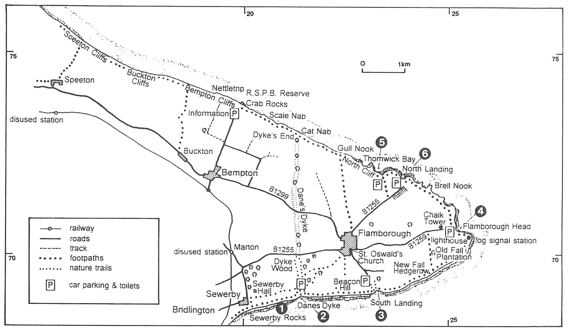
Access to the coast is easy; all the bays have adequate parking
Note: All locations must be visited on falling tides. Times are available from H.M. Coastguard on the harbour at Bridlington. Safety helmets are recommended as cliffs are subject to falls and mud slides. Suitable footwear is required as the foreshore rocks can be very slippery.
Maps
O.S. 1:25 000 Sheet TA 26/27 Flamborough; O.S. 1:50 000 Sheet 101 Scarborough & Bridlington; B.G.S. 1:63 360 Sheet 65 Bridlington.
Geological background
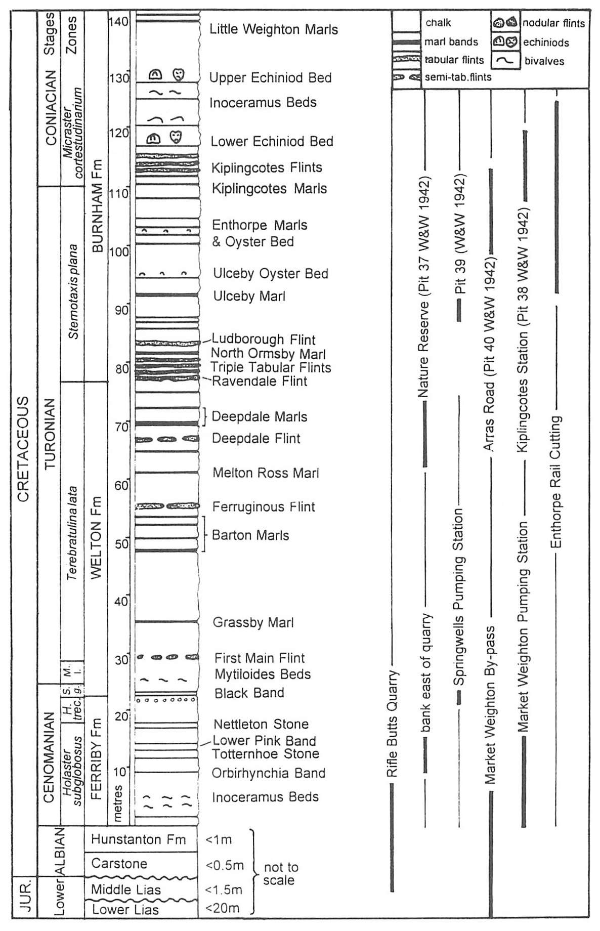
The chalk succession exposed between Sewerby and Bempton Cliffs, about 400 m thick, is subdivided on biostratigraphical and lithostratigraphical criteria
In late Cretaceous times, the chalk sea transgressed over the fault-controlled topography of the Market Weighton Block, and represents a contrast in depositional history to that displayed at Speeton. The earliest beds (
The chalk is covered by drift from the most recent Devensian ice-sheet that banked up against the headland to form the Flamborough Moraine, which contains exotic erratics from Northern England and Scandinavia.
Excursion details
Locality 1, Sewerby [TA 202 687]
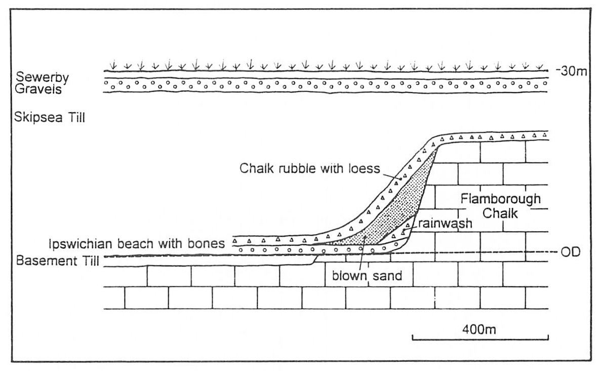
Some 250 m south, the gently dipping chalk cliffs end at the Sewerby Buried Cliff
Return to Sewerby Steps and the car park or coastal path, or continue east along the beach to Danes Dyke, with many fossils, including sponges, to be found en route.
Locality 2, Danes Dyke [TA 231 692]
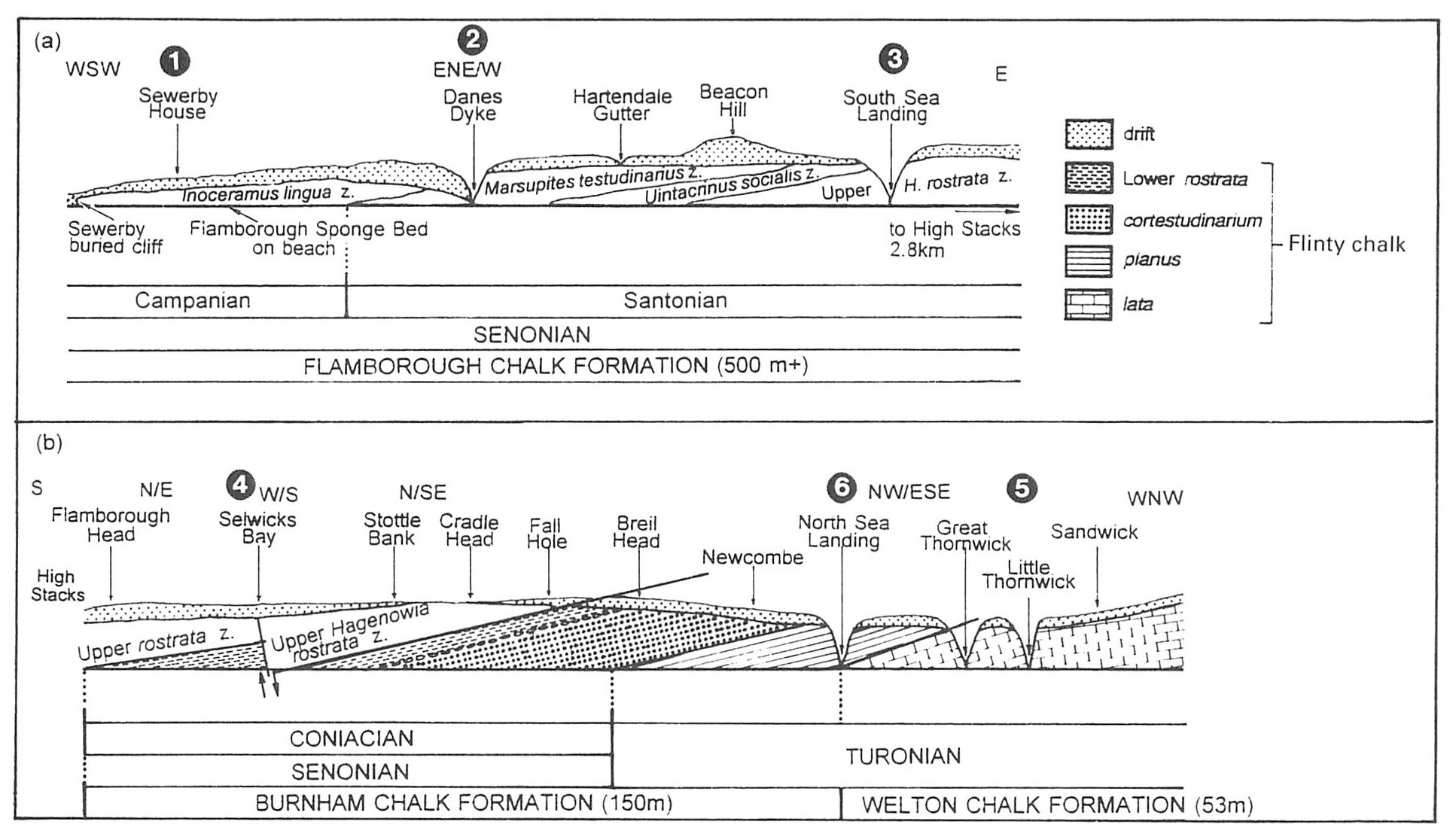
Walking west, the southerly dip brings down the upper part of the Marsupites testudinarius Biozone for about 200 m to a prominent group of four boulders on the beach. The thinly bedded, flintless marly chalk is full of the isolated calyx plates (see crinoid) of the index fossil, and their density increases upwards through the zone, with complete examples of the stemless calyxes not uncommon, especially along marl bands. Other fossils include echinoids, belemnites, brachiopods, and starfish ossicles from faecal pellets.
From Danes Dyke return to the car park or the coastal path, or else, but only on a falling tide, cross the Danes Dyke fault, which throws down to the south, and follow the shoreline eastwards out of the bay for 500 m to Hartendale Gutter
For about 200 m the more massive-bedded chalk, with bedding plane stylolites formed by loading and solution, is cut in the Marsupites testudinarius Biozone, but on approaching Hartendale Gutter, the calyx plates become fewer and the succession passes into the Uintacrinus socialis Biozone. This stemless crinoid is present locally and may have been (like Marsupites) a deeper-water species swept into the Northern Province, as these two fossils are common at this horizon throughout England. The section at Hartendale Gutter is one of the few British localities for complete specimens, but more commonly they are found as isolated calyx plates or groups of plates and arm ossicles, indicating individuals falling into quiet conditions on the sea floor. Other fossils found include echinoids, brachiopods, corals, belemnites and sponges.
Return to Danes Dyke, or continue east to South Landing via the coastal path or beach (only on a falling tide.)
Locality 3, South Landing [TA 231 693]
Take Landings Road from Flamborough to South Landing where there are parking, picnic and toilet facilities. Descend to the beach along the road used for launching boats. The ravine is very similar to Danes Dyke and is probably formed along a fault line. The bay is cut in massive-bedded flintless chalk. The index fossil is very rare and the small echinoid Hagenowia blackmorei is found instead. Other fossils include echinoids, belemnites and sponges.
It is not recommended to continue further east on the beach towards Flamborough. The coastal path should be taken to Selwicks Bay.
Locality 4, Selwicks Bay [TA 255 708]
Flamborough and Burnham Chalk Formations, Hagenowia rostrata Biozone. Take the B1259 from Flamborough to the car park by the lighthouse (with cafe, gift shop and toilets), noting the older lighthouse on the golf course. Chalk does not make a good building stone and this is one of the few Flamborough buildings made of it. Walk to the top of the steps to view the bay. The vertical chalk cliffs contrast with the grass-covered slopes of the glacial drift, which support a great variety of animal and plant life, especially orchids. Walk down to the top of the new steps. At low tide the geology of the bay is well displayed, as are marine erosion features, especially the prominent stack (known locally as Adam).
Descend to the beach (best at low water). The chalk is cut by the Selwicks Bay Fault, downthrowing about 20 m to the north, and part of the Howardian–Flamborough Fault Zone that runs east–west across the Wolds and marks the reactivated edge of the Market Weighton Block. The main fault zone is marked by a large mass of fault breccia, cemented by crystalline calcite. The complex nature of the bay is best revealed on the wave-cut platform by walking north across the bay starting at the prominent brown flint band that marks the junction of the flintless Flamborough and flinty Burnham Formations. The fault breccia is a complex structure of fractured blocks with several stages of tension and compression indicated by cross-cutting calcite veins. On the north side of the bay the
The beach has many erratics, including semi-precious agates and cornelians. A purple sand often accumulates in patches and is largely composed of garnet.
Return to the car park or walk north along the cliff to Thornwick and North Landing. All cliff walks display magnificent coastal features, with a wide variety of nesting birds in spring and summer.
Locality 5, Thornwick Bay [TA 234 722]
Burnham and Welton Chalk Formations, Stenotaxis planus (38 m) and
Locality 6, North Landing [TA 238 720]
Burnham and Welton Chalk Formations, Sternotaxis planus and
The chalk is massive and flinty, with a marl band forming a prominent ledge dipping into the bay and into the fault line cave on the north side. A band above it contains oysters, brachiopods and the index fossil, Sternotaxis planus. The flints are very prominent in the bay, especially the 'Paramoudra Flints', large masses up to 1 m length which appear to be original burrows expanded by overfilling with flint.
Return to the car park or take the coastal path back to Bridlington, or north to Speeton via the R.S.P.B. reserve at Bempton
None of the coastal sections below Bempton cliffs should be visited even at low tide.