Stratigraphy and magmatism in the uppermost Dalradian of the SW Scottish Highlands: A field excursion to Tayvallich, Loch Avich and Tarbert (Loch Fyne), June 1999
Ewan K Hyslop and Elizabeth A Pickett (British Geological Survey, Murchison House, West Mains Road, Edinburgh, EH9 3LA.)
Natural Environment Research Council, British Geological Survey., Onshore Geology Series Technical Report WA/99/73
Geographical Index: SW Highlands, Scotland, UK.
Bibliographical reference: Hyslop, E K, and Pickett, E A. 1999. Stratigraphy and magmatism in the uppermost Dalradian of the SW Scottish Highlands: A field excursion to Tayvallich, Loch Avich and Tarbert (Loch Fyne), June 1999 British Geological Survey Technical Report WA/99/73
NERC 1999. Edinburgh, British Geological Survey 1999
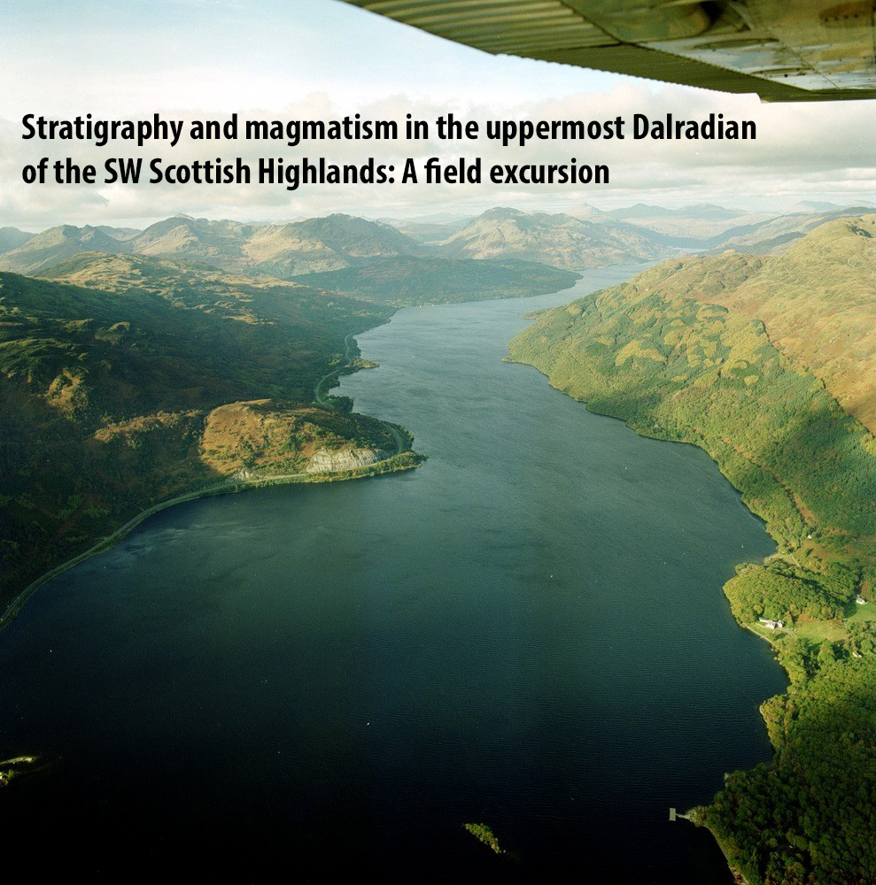
(Front cover) Oblique aerial view looking north-east along middle part of Loch Lomond from above Rowardennan. Rubha Mor, Tarbet, Loch Lomond, Ben Vane and Ben Vorlich. The Rubha Mor road cut on the re-aligned A82 is prominent on the west side of Loch Lomond. The road is cut through a particularly massive gritty arenite unit that changes its dip from steeply to the south-east to near horizontal at the northern end on the rock cut. It lies at the Downbend axis in Dalradian Beinn Bheula Schists (= Ben Ledi Grits). Ben Lomond lies to the right and Beinn Narnian, Ben Vane and Ben Vorlich in the distance. British Geological Survey Image: P001238. Photographer: F.I. MacTaggart.
Executive summary
The Southern Highlands Project is a programme of geological mapping and research into the rocks of the uppermost Dalradian Supergroup, being undertaken by the British Geological Survey. Within the project several collaborative ventures have been developed with other organisations, in particular the Geological Survey of Northern Ireland and the universities of Edinburgh, Kingston and Leicester. Following an excursion to Northern Ireland in 1998, a second field meeting was held in Argyll in the SW Highlands of Scotland in June 1999. The purpose of the meeting was to bring together all those involved in the project in a field setting that would stimulate discussion and continue the momentum of research generated over the previous years. The Argyll area in the SW Highlands is characterised by excellent outcrops of upper Dalradian rocks, and in particular extensive volcanogenic deposits which are critical to understanding the tectonic evolution of the Dalradian Supergroup. Additionally the location (the westernmost Dalradian on the Scottish mainland) provides a link across the North Channel to the Dalradian rocks of the NE Antrim coast.
This report is derived from a field guide produced for the excursion participants. Following an introduction to the Dalradian geology and stratigraphy of the SW Highlands, it documents in detail the localities visited during the excursion. The report also includes recent and new data obtained by BGS concerning the petrology and geochemistry of the Tayvallich and Loch Avich volcanic rocks and the Green Bed volcaniclastic suite. Finally it includes a discussion of these rocks in the context of the unstable tectonic regime prevailing immediately prior to the opening of the Iapetus Ocean.
The rocks described in this guide belong to the Argyll and Southern Highland Groups which form the upper part of the Late Proterozoic Dalradian Supergroup of Scotland, Northern Ireland and western Ireland. Reviews of the Dalradian Supergroup conclude that the preserved outcrop, extending across the Grampian Highlands of Scotland to the west coast of Ireland, represents a segment of a former very extensive continental shelf sequence forming the NW margin of a broad continental rift. The bulk of the Argyll Group represents alternating shelf and basin deposition on the rifting continental margin; however, by upper Argyll Group and Southern Highland Group times (topmost Argyll Group dated at 595 Ma), the tectonic regime had changed to one of continuous rapid basin subsidence. This period was characterised by extensive volcanism which recorded rupturing of the continental crust and initiation of the Iapetus Ocean.
Three separate excursions (which can be visited in any order) are described in this guide, each allowing examination of the range of igneous rocks and associated metasediments in the top of the Argyll Group and the overlying Southern Highland Group.
- In the Kilmelford–Loch Avich area the stratigraphy and changing sedimentology of the uppermost Dalradian rocks are examined in a 10 km W to E traverse. Associated intrusive and extrusive igneous rocks (including the Loch Avich Lavas) are also examined in this area;
- the igneous rocks at the top of the Argyll Group are examined on the Tayvallich
Peninsula, where extensive volcaniclastic deposits, pillow lavas, and intrusions typical of the Tayvallich Volcanic Formation are exposed; (3) volcaniclastic (sedimentary) 'Green Beds' and associated metasedimentary rocks are examined around Tarbert, Loch Fyne. These rocks may reflect more distal turbidite resedimentation of volcanic-rich material, and are characteristic of the Southern Highland Group outcrop in Scotland and Ireland.
Contents
1. Introduction
1.1 Background
1.2 Geological background
1.2.1 Argyll Group
1.2.2 Southern Highland Group
1.3 Basic magmatism in the upper Dalradian of the SW Scottish Highlands
2. Tarbert (Loch Fyne): sedimentology of Green Beds and associated lithologies
2.1 Introduction
2.2 Background
2.2.1 The Green Beds
2.2.2 Green Beds and stratigraphy at Tarbert (Loch Fyne)
2.3 Excursion itinerary
2.3.1 Locality 1: Tarbert to Barmore Island
2.3.2 Locality 2: Mealdarroch Point, Tarbert
3. Tayvallich Peninsula: igneous and volcanogenic processes
3.1 Introduction
3.2 The Tayvallich Volcanic Formation (Argyll Group)
3.3 Excursion itinerary
3.3.1 Locality 1: Keills jetty
3.3.2 Locality 2: Keillmore
3.3.3 Locality 3: Port a' Bhuailteir
3.3.4 Locality 4: 595Ma Quartz keratophyre
3.3.5 Locality 5: An Aird Peninsula
3.3.6 Locality 6: Port an Sgadain & Port nan Clach Cruinn
4. Traverse between Loch Melfort and Loch Avich: stratigraphy of the uppermost Dalradian
4.1 Introduction
4.2 Background
4.2.1 Kilmelford/Loch a' Phearsain area
4.2.2 Loch Avich Lavas (Southern Highland Group)
4.3 Excursion itinerary
4.3.1 Locality 1: Ardrishaig Phyllite
4.3.2 Locality 2: Shira Limestone
4.3.3 Locality 3: Metabasite
4.3.4 Locality 4: Ardrishaig Phyllite and metabasic intrusions
4.3.5 Locality 5: Crinan Grit
4.3.6 Locality 6: Loch an Losgainn Mor
4.3.7 Locality 7: Lagalochan (Tayvallich Volcanics)
4.3.8 Locality 8: Duaig Farm (Loch Avich Grits)
4.3.9 Locality 9: Drissaig (Loch Avich Lavas)
5 The geochemistry of the Green Beds and associated Dalradian meta-igneous suites
5.1 Introduction
5.2 Classification, variation and discrimination diagrams
5.2.1 Igneous classification diagrams
5.2.2 Variation diagrams
5.2.3 Sedimentary mixing
5.2.4 Tectonic discrimination diagrams
5.3 Geochemistry of upper Dalradian basic rocks in relation to mantle plumes
5.4 Rare earth element (REE) data for Dalradian basic igneous and sedimentary rocks
5. Acknowledgements
6. Reference
1. Introduction
1.1 Background
The British Geological Survey (BGS) and Geological Survey of Northern Ireland (GSNI) are currently mapping in the uppermost Dalradian rocks of the Southern Highlands of Scotland and the Sperrin Mountains of Northern Ireland. Part of this work involves research into metabasic and associated metasedimentary rocks that form a distinctive feature within the stratigraphy of the Argyll and Southern Highland Groups. Characterisation of these lithologies has been undertaken in order to shed light on the nature and evolution of the tectonic environment and original sedimentary basins which constitute the upper part of the Dalradian Supergroup.
Metamorphosed rocks of basic igneous composition, commonly termed Green Beds and epidiorites, have long been used as marker horizons for stratigraphical correlation in the Dalradian of Scotland and Northern Ireland. However, their origin and distribution are still relatively poorly understood. In many places original textures have been destroyed during deformation and metamorphism, and it is difficult to establish whether the rocks were originally igneous intrusive rocks (e.g. sill complexes, epidiorites), extrusive volcanic rocks (lavas and tuffs), or resedimented basic igneous material (volcaniclastic sedimentary rocks). Initial characterisation of these lithologies in both Scotland and Northern Ireland have been reported by Pickett (1997) and Hyslop and Pickett (1998, 1999).
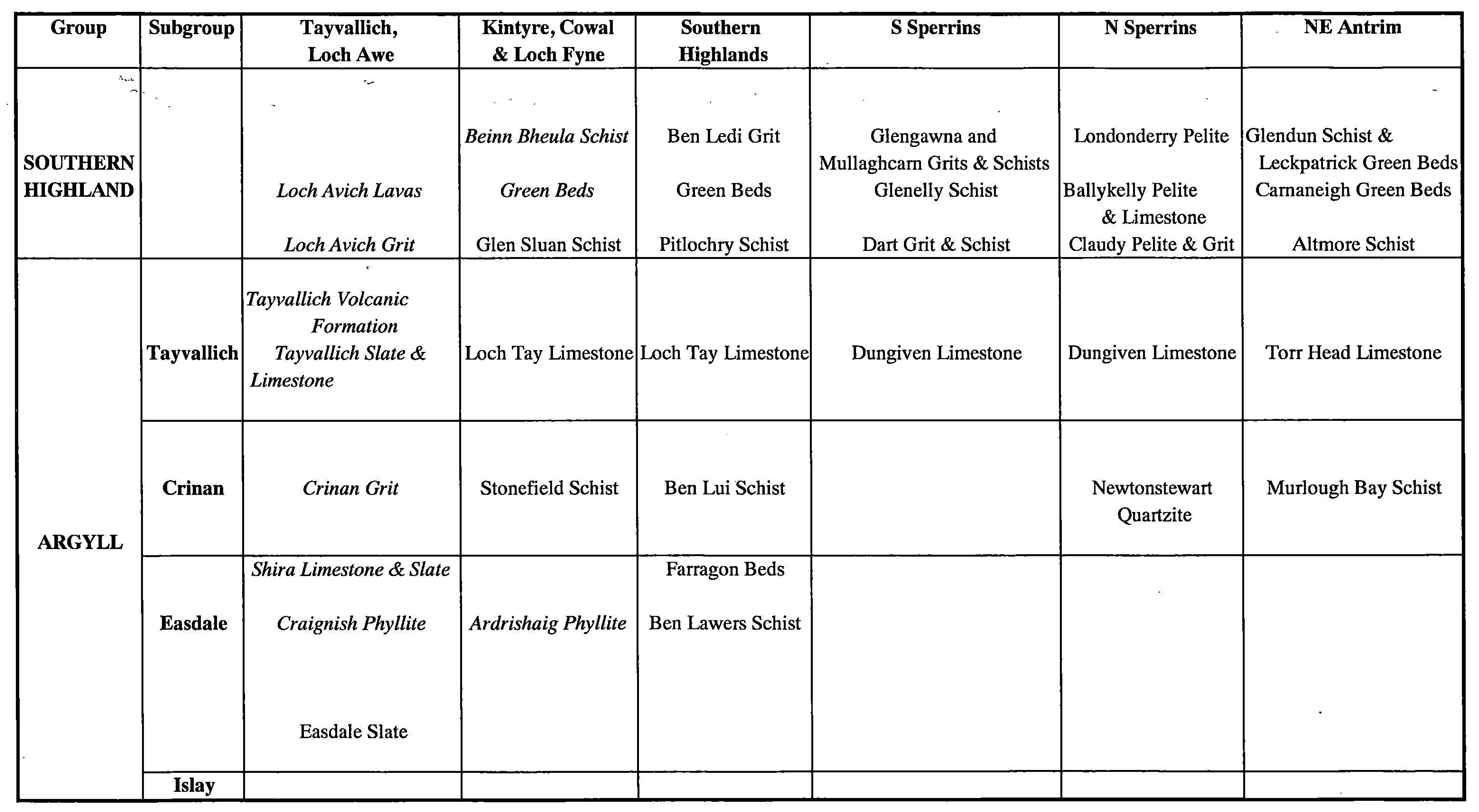
Much of the current Dalradian correlation within Northern Ireland relies upon key marker horizons which contain distinct lithological associations. For example, the Dungiven Formation (Sperrin Mountains) and the Torr Head Limestone Formation (NE Antrim) have been correlated with the Loch Tay Limestone Formation in Scotland and the Culdaff Limestone in Donegal. On the basis of these correlations the Dungiven and Torr Head Formations are equivalent to the Tayvallich Subgroup of the Argyll Group (middle Dalradian). However, more detailed stratigraphical correlation of individual formations within the Southern Highland Group between the Sperrins and Antrim and also between Ireland and Scotland are more difficult to achieve. Indeed it is even more difficult to make direct lithostratigraphical correlation across the axis of the major recumbent fold structure which forms the Sperrin Mountains. Metabasic rocks are present at various levels within the Dalradian stratigraphy in Northern Ireland. It is hoped that the characterisation of individual metabasic units and Green Beds will facilitate such correlation both within Northern Ireland and with the Scottish Dalradian.
This guide is designed to accompany a field excursion to the upper Dalradian rocks of the SW Highlands of Scotland involving staff from BGS, GSNI and university collaborators. In this region metasediments and basic intrusive and extrusive igneous rocks of the Tayvallich Subgroup forming the uppermost rocks of the Argyll Group, pass upwards into the Southern Highland Group, coinciding with a period of basin subsidence and deepening. The purpose of the field excursion is to examine the range of igneous rocks and associated metasediments, from the top of the Argyll Group and into the overlying Southern Highland Group. The planned excursion will involve 2.5 days; one day examining the Tayvallich Volcanic Formation where extensive volcaniclastic deposits, pillow lavas, and intrusions are examined, including the dated 595 ± 4Ma quartz keratophyre (Halliday et al. 1989). Day 2 is a stratigraphical traverse, examining changing sedimentation types from the upper Argyll Group to the top of the overlying Southern Highland Group, and their relationship to intrusive and extrusive igneous activity (including the Loch Avich Lavas). The third locality allows examination of typical Green Beds representing distal turbidite resedimentation of volcanic-rich material.
1.2 Geological background
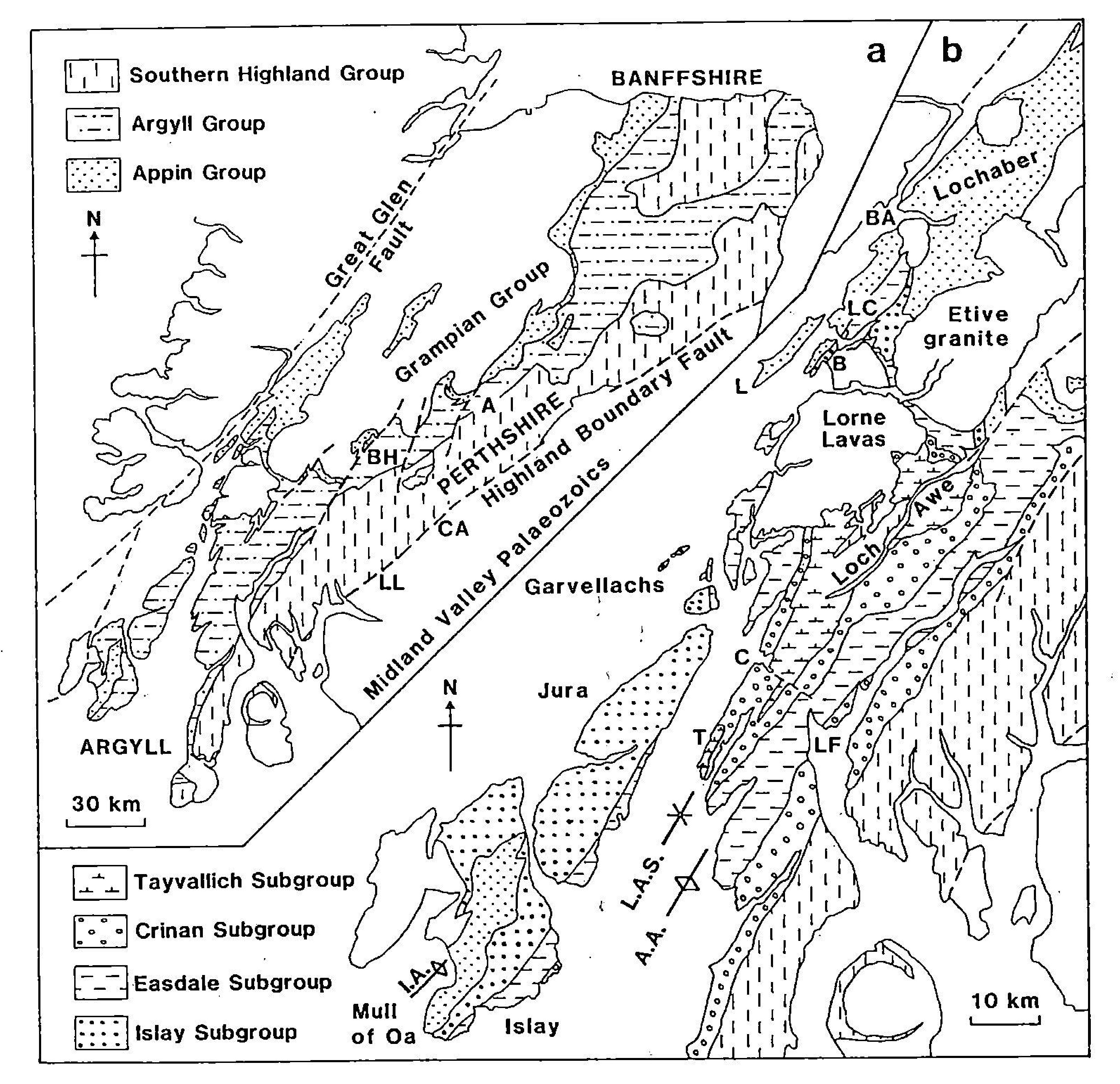
The rocks described in this guide belong to the Argyll and Southern Highland Groups which form the upper part of the Late Proterozoic Dalradian Supergroup of Scotland, Northern Ireland and western Ireland (Figures 1 and 2). Reviews of the Dalradian Supergroup conclude that the preserved outcrop, extending across the Grampian Highlands of Scotland to the west coast of Ireland, represents a segment of a former very extensive continental shelf sequence forming the NW margin of a broad continental rift (e.g. Anderton 1985). The Argyll Group represents alternating shelf and basin deposition on the rifting continental margin. By upper Argyll Group and Southern Highland Group times (topmost Argyll Group dated at 595 Ma; Halliday et al. 1989) the tectonic regime had changed to one of continuous rapid basin subsidence. This period was characterised by extensive volcanism which recorded rupturing of the continental crust and initiation of the Iapetus Ocean.
1.2.1 Argyll Group
The Argyll Group has been divided into four subgroups (Figure 2). In this excursion we will examine rocks from the Easdale, Crinan and Tayvallich Subgroups. The Easdale and Crinan Subgroups contrast with the preceding Argyll Group sedimentation (stable shelf deposits of the Islay Subgroup) by representing tectonically unstable basin deposits and turbidites. Rapid basin development at the base of the Easdale Subgroup is indicated by the Easdale Slate, passing upwards into the shallower water Craignish (Ardrishaig) Phyllite and Shira Limestone. The Crinan Subgroup is characterised in this area by the Crinan Grit (equivalent to the Stonefield and Ben Lui Schists to the east), comprising psarnmites with interbanded phyllite, slate and carbonate.
The Tayvallich Subgroup contains basin deposits (e.g. Tayvallich Slate), turbidites and a dominant turbiditic carbonate horizon (the Loch Tay Limestone, Deeside Limestone) which extends across Scotland and N Ireland to Donegal and forms one of the principal marker bands of the Dalradian succession. In N Ireland and Donegal limestones of the Tayvallich Subgroup include the Ton Head Limestone in NE Antrim, Dungiven Limestone in the Sperrin Mountains and the Culdaff Limestone in Inishowen. A further characteristic feature of the Tayvallich Subgroup is the presence of thick sequences of volcanic rocks (mainly basaltic pillow lavas, tuffs and hyaloclastites) which occur throughout the subgroup but which reach their maximum development at the top and into the overlying Southern Highland Group. These sequences characterise the Tayvallich Peninsula in western Scotland and extend into N Ireland (e.g. Craig pillow lavas and Butterlope volcanics in the Sperrins), and constitute the most extensive development of volcanic rocks in the Dalradian succession. The main centre of extrusive activity was in the Tayvallich–Loch Awe area of the SW Highlands of Scotland where pillow lavas and tuffs attain a thickness of up to 2 km (Borradaile 1973; Graham 1976).
1.2.2 Southern Highland Group
The Southern Highland Group forms the uppermost lithostratigraphic unit of the Dalradian Supergroup and can be traced from the NE Grampians of Scotland to western Ireland. In Scotland the main outcrop of the Southern Highland Group forms a belt up to 35 km wide which extends from the Mull of Kintyre in the west to Stonehaven on the east coast. The group is also preserved in the cores of the Loch Awe Syncline (in the west) and the Turriff Syncline (in the north-east). The Southern Highland Group in Scotland predominantly comprises a 3–4 km thick sequence of turbiditic metagreywackes, psammites and phyllites that show lateral facies variations (Harris and Fettes 1972). Coarse-grained, poorly sorted turbiditic metagreywackes dominate the upper part of the group, whereas the lower levels contain a larger proportion of phyllitic units and locally extensive developments of the volcaniclastic Green Beds. A similar situation exists in the Southern Highland Group of Northern Ireland where Green Bed-type units occur within a largely siliciclastic sequence (e.g. Carnaneigh Green Beds and surrounding metasediments in NE Antrim). In Scotland the Loch Avich Lavas form the only known extrusive rocks within the Southern Highland Group and have been stratigraphically correlated with the Green Beds (Anderton 1985; Stephenson and Gould 1995).
1.3 Basic magmatism in the upper Dalradian of the SW Scottish Highlands
Igneous activity during deposition of the Dalradian Supergroup was linked to crustal extension, which resulted in high-level rift faulting in Argyll Group times. The continuation of crustal stretching associated with opening of the Iapetus Ocean to the SE of the Dalradian basin (e.g. Graham 1976), led to the initiation of major igneous activity. The main centre of extrusive activity in late Argyll-early Southern Highland Group times was located in the Tayvallich–Loch Awe area of the SW Highlands. The basic magmatic suite in this area comprises a thick (>5 kin) metadolerite-metagabbro sill complex together with an overlying succession of submarine pillow lavas, hyaloclastites and tuffs (Tayvallich Volcanic Formation and Loch Avich Lavas) (Graham 1976). Graham (1976) and Graham and Bradbury (1981) described the petrochemistry of the metabasaltic suite and suggested that the rocks may record continental rifting, representing the first stage of oceanic spreading.
The earliest evidence of volcanic activity in the Upper Dalradian has been recorded in the Islay Subgroup of the Argyll Group, where minor lavas and tuffs are present. However, the first major volcanic activity is recorded in the upper Easdale Subgroup with the appearance of laterally extensive basaltic and tuffaceous rocks that appear to have been erupted from several volcanic centres. This early widespread magmatic activity is represented by the Farragon Beds which can be traced for 60 km along strike. These metavolcanic schists have been interpreted as lavas and tuffs intercalated with sediment bands, and recent mapping has shown that two further metabasic units (Laoigh Metabasites and Balnacraig Metabasites) occur adjacent to the Farragon Beds (Goodman and Winchester, 1993). Geochemical studies by these authors suggest the derivation of the metavolcanic Farragon Beds and adjacent units from within-plate tholeiites, entirely consistent with magmatism associated with crustal extension.
2. Tarbert (Loch Fyne): sedimentology of Green Beds and associated lithologies
2.1 Introduction
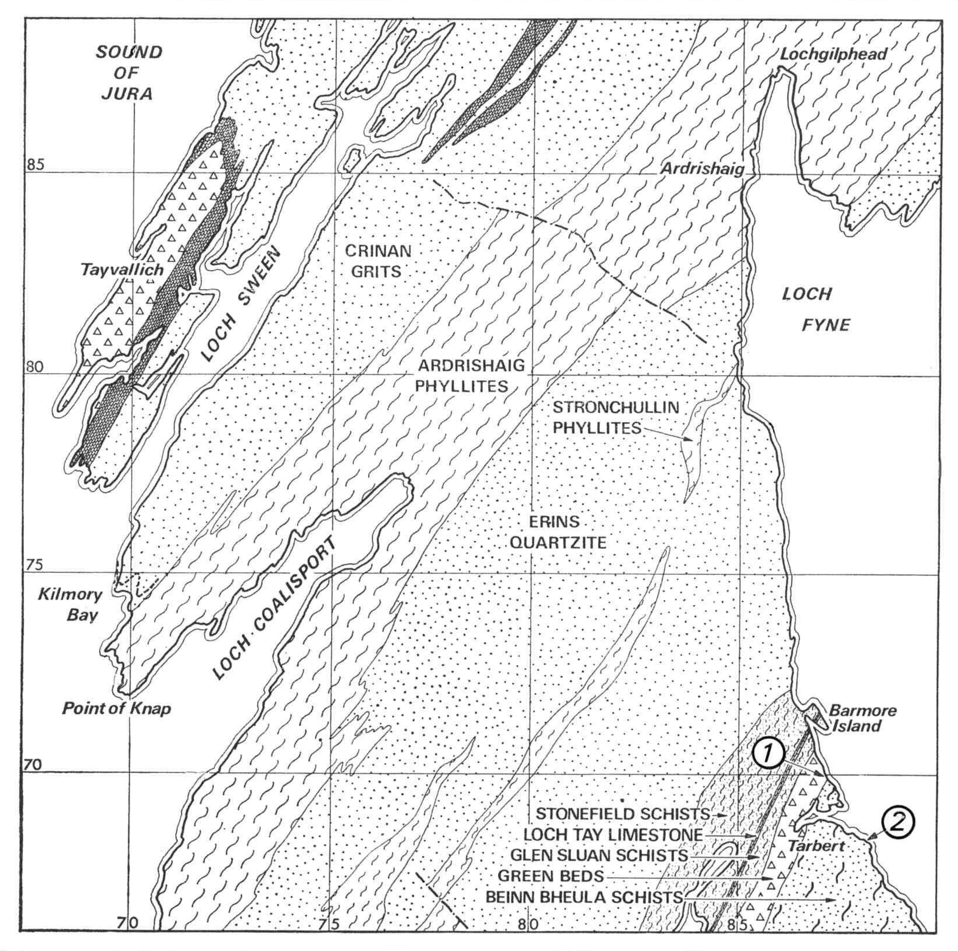
This short (half-day) excursion examines the stratigraphy of the Southern Highland Group in the SW Highlands. In the Tarbert area a complete stratigraphy is present from the Loch Tay Limestone, representing uppermost Argyll Group, passing upwards into the three main formations of the Southern Highland Group in this region; the Glen Sluan Schist, the Green Beds and the Beinn Bheula Schist (Figure 2), (Figure 3). This excursion concentrates on the sedimentology of the Green Beds and, if time permits, structures in the overlying Beinn Bheula Schist will also be examined.
2.2 Background
2.2.1 The Green Beds
The term 'Green Beds' was introduced by the Geological Survey in Scotland in the late 19th century to describe the distinctive green 'epidotic and chloritic schistose grits' that were recognised and mapped across the Southern Highlands. The Green Beds are now assigned to the Southern Highland Group and form a distinctive stratigraphic unit up to 1000 m thick which extends from Donegal, through the Sperrin Mountains in Northern Ireland, to the Scottish Grampian Highlands (Stephenson and Gould 1995). In the Sperrin Mountains several volcaniclastic Green Bed horizons are intercalated with Southern Highland Group metabasites and metaclastic rocks (GSNI 1997).
In Scotland the Green Beds can be traced from the Mull of Kintyre to Glen Clova. They typically occur in several horizons towards the base of the Southern Highland Group and have gradational contacts with adjacent psammites and schists. The Green Beds comprise a series of epidotic and/or chloritic metagreywackes and psammites, interbedded with chloritic and/or epidotic schists. These lithologies become hornblende-bearing at higher metamorphic grades. Graded bedding, soft-sedimentary deformation, quartz clasts and lenses of obvious detrital material clearly indicate a sedimentary origin. Metabasic sheets within the Green Beds probably represent contemporaneous shallow intrusions.
2.2.2 Green Beds and stratigraphy at Tarbert (Loch Fyne)
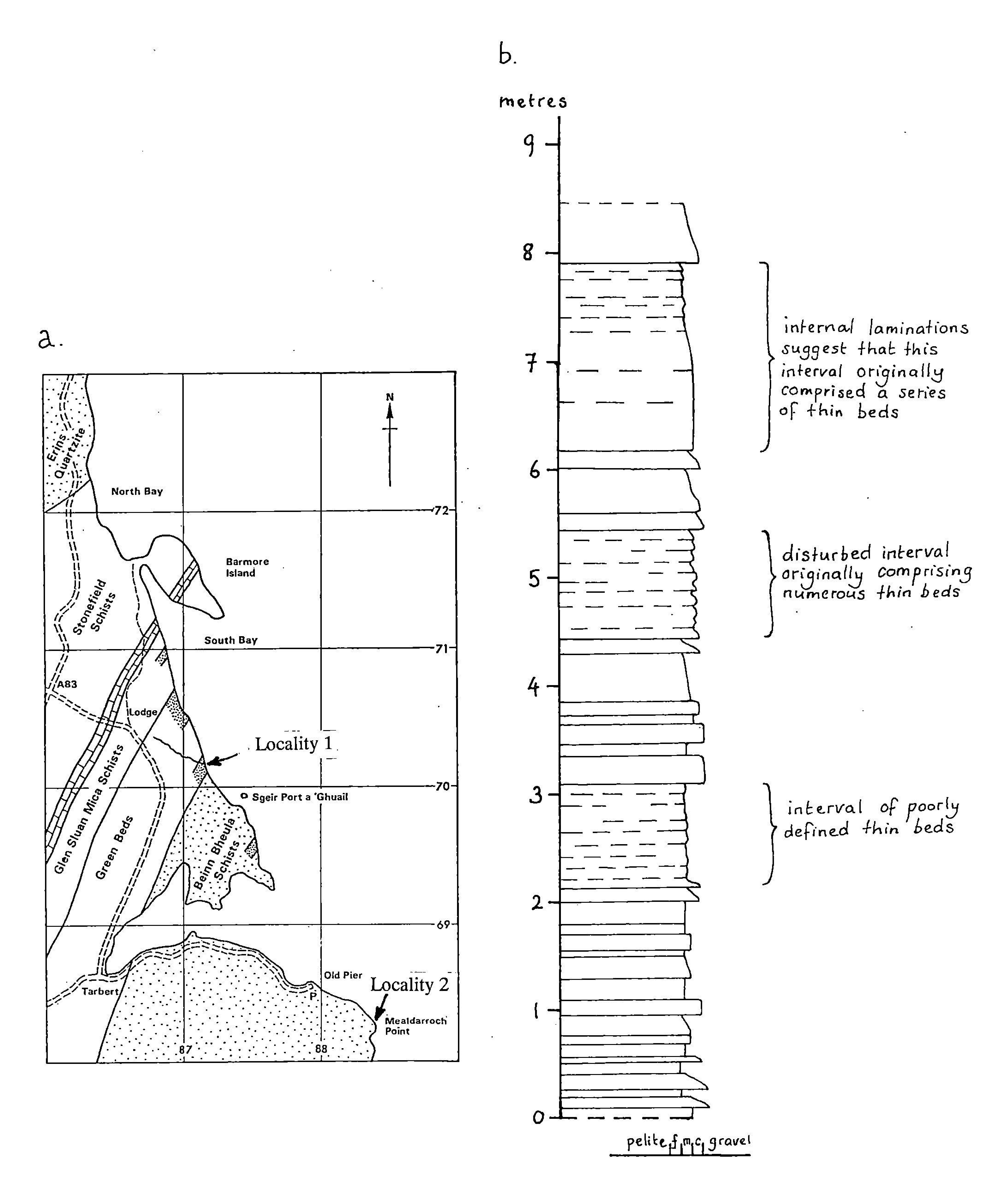
At Tarbert on Loch Fyne in the SW Scottish Highlands the Green Beds form four main horizons that outcrop along the coast between Tarbert and Barmore Island (Figure 4). Fresh surfaces are well exposed at the mouth of the burn at [NR 8716 7020]. At this locality the Green Beds are well bedded with graded bedding indicating younging to the south-east. Bed thicknesses are up to 50 cm but are generally in the range 1–20 cm. Northwards along the coast the Green Beds are interbedded with coarse grained sandstones and siltstones. The entire sequence is considerably folded.
This locality provides an opportunity to examine the Southern Highland Group stratigraphy, where a mixture of Green Beds and siliceous metasediments probably represent the lateral stratigraphic equivalent of Loch Avich Grits and Lavas (Stephenson and Gould 1995). The rocks are steeply inclined, on the SE side of the Ardrishaig Anticline.
At the base of the Tarbert succession is a poorly exposed limestone, correlated with the Loch Tay Limestone. It is siliceous in places and interbedded with pelitic schists, and in parts showing graded units. Directly above the limestone are the Glen Sluan Schists (correlated in the east with the Dunoon Phyllite and Pitlochry Schist) forming the base of the Southern Highland Group and marking the onset of deepwater turbidite sedimentation above the limestones and volcanics of the Tayvallich Subgroup. The Glen Sluan Schists are predominantly schistose pelitic turbidites. They are overlain by the Green Beds which here form a distinctive stratigraphical unit consisting of a mixture of chloritic green schists interbedded with metagreywackes and siliceous psammites and grits. The Green Beds are directly overlain by the Beinn Bheula Schists, a predominantly turbiditic unit of fine grained metagreywackes with local gritty psammites, slates, siltstones and albite schists, forming the uppermost Southern Highland Group metasediments in the SW Highlands, correlated with the Ben Ledi Grits in the Southern Highlands.
2.3 Excursion itinerary
2.3.1 Locality 1: Tarbert to Barmore Island [NR 872 702].
Park in the layby approximately 1 km north of Tarbert just north of the entrance to Barfad. Walk past the small disused quarry and descend to the shore through a wood to the mouth of a burn at [NR 872 702] (Locality 1, (Figure 4)).
At this locality Green Beds are very well exposed beside a small shingle beach where they form a series of well bedded graded units rich in chlorite and epidote. Bedding typically ranges from 1 to 20 cm thickness, with some thicker units up to 50 cm which contain fine grained laminated beds typically <2cm thick. Bedded units show graded bedding younging to the SE. Most beds typically comprise graded units with gritty bases fining upwards to medium/fine grained sandstone grade tops (Figure 4). There are occasional small lenses of coarse sandstone and dark green mudstone lenses. Bed bases contain abundant quartz clasts up to 6 mm in size, typically white or clear quartz, but also displaying less common distinctive pink and blue quartz. Quartz clasts are commonly elongate along the bedding parallel fabric. Both white mica and biotite are common in the Green Beds, with biotite forming prominent fresh flakes up to 1 mm in size and aligned to form a fabric oblique to the bedding. Common weathered-out orange coloured spots may represent altered sulphides.
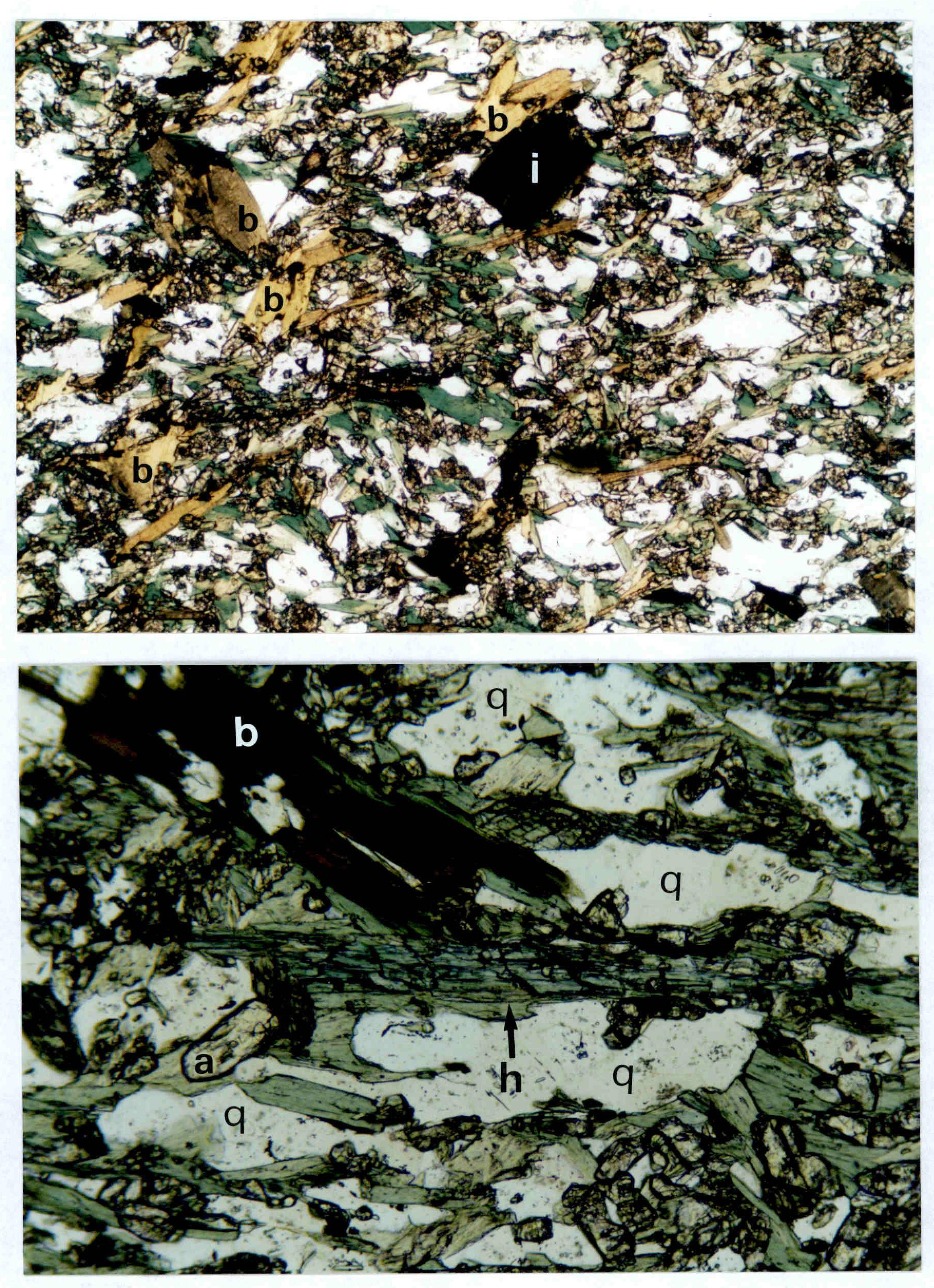
Examination of thin sections of the Tarbert Green Beds shows that they are dominated by epidote and chlorite with subordinate quartz and feldspar (Figure 5). Some samples contain acicular blue-green hornblende and blocky clinozoisite. They show compositional banding with more siliceous bands containing large quartz and plagioclase clasts which have been deformed into augen. Graded bedding is present, with coarser grained siliceous (clast-rich) bases grading upwards into finer grained chlorite-epidote rich bed-tops. Aligned chlorite forms a planar fabric parallel to the compositional banding. Tourmaline is present as small grains (possibly detrital) with substantial metamorphic overgrowths. Large blocky biotite is common and cross-cuts the main fabric, suggesting it has formed later. Epidote-poor samples are semipelitic in composition, dominated by white mica and chlorite.
Walk north along the rocky shore observing thick siliceous horizons which comprise siliceous rocks with gritty bands with some mica schists and occasional green coloration. Detrital blue coloured quartz and orange feldspars are common in the grits. The rocks are locally highly folded. These siliceous rocks which occur adjacent to the Green Beds are mainly micaceous psammites, dominated by quartz, feldspar, white mica, chlorite and biotite. They contain epidote and zoisite in small amounts, suggesting some degree of basic input (i.e. highly 'dilute' Green Beds). Metamorphic garnet and zoisite are common in these rocks, although garnet is commonly chloritised.
Continue north as far as a small shingle beach with good Green Bed exposures which strike directly towards the south end of Barmore Island. Here distinct dark biotite-rich bands typically 1–5 cm thick occur within c.30 cm thick beds. The beds are graded and appear to young to the SE. Return to the vehicles through the wood.
2.3.2 Locality 2: Mealdarroch Point, Tarbert [NR 883 684].
If time permits drive south through Tarbert village turning eastwards past the fishing harbour and piers towards Mealdarroch Point [NR 883 684]. Park at the road end and examine the coastal exposures between here and the point.
At this locality excellent exposures of the Beinn Bheula Schists represent the uppermost Southern Highland Group rocks in the SW Highlands, equivalent to the Ben Ledi Grits in the Southern Highlands. The lithologies are a series of schistose grits and quartzose mica schists. Despite the fact that the rocks are highly deformed, occasional graded bedding in bands of schistose grits shows that the rocks are inverted, folded around a series of NE–SW trending folds related to the Tarbert Monoform (Roberts 1977). A coarse cleavage which is axial planar to these folds crenulates an earlier bedding parallel cleavage and dips moderately to the SE. Fold limbs are alternately steeply dipping and flat-lying, and progressively towards the SE the flat lying limbs become dominant, passing into the Cowal Flat Belt; the equivalent of the lower inverted limb of the Tay Nappe (Roberts 1977).
3. Tayvallich Peninsula: igneous and volcanogenic processes
3.1 Introduction
The Tayvallich Peninsula contains some of the best exposures of submarine extrusive and associated reworked volcanic deposits (pillow lavas and hyaloclastites) in the British Isles. This excursion will allow examination of pillow lavas and associated intrusive rocks (metabasites) as well as associated sequences of reworked tuffs and volcaniclastic sediment, including limestones containing volcanic clasts and so-called boulder beds. The sequence also includes a series of quartz keratophyre intrusions, one of which has been dated at 595 ±4Ma, providing an age for the Tayvallich Subgroup and implying that most of the Dalradian Supergroup is Precambrian in age. Part of the excursion will also examine the lower boundary of the Tayvallich Volcanic Formation, where lobes of pillow lava have been forced into the underlying soft-sediment producing push folds and load structures. The geology of the Tayvallich Peninsula in relation to the regional stratigraphy is shown in (Figure 3).
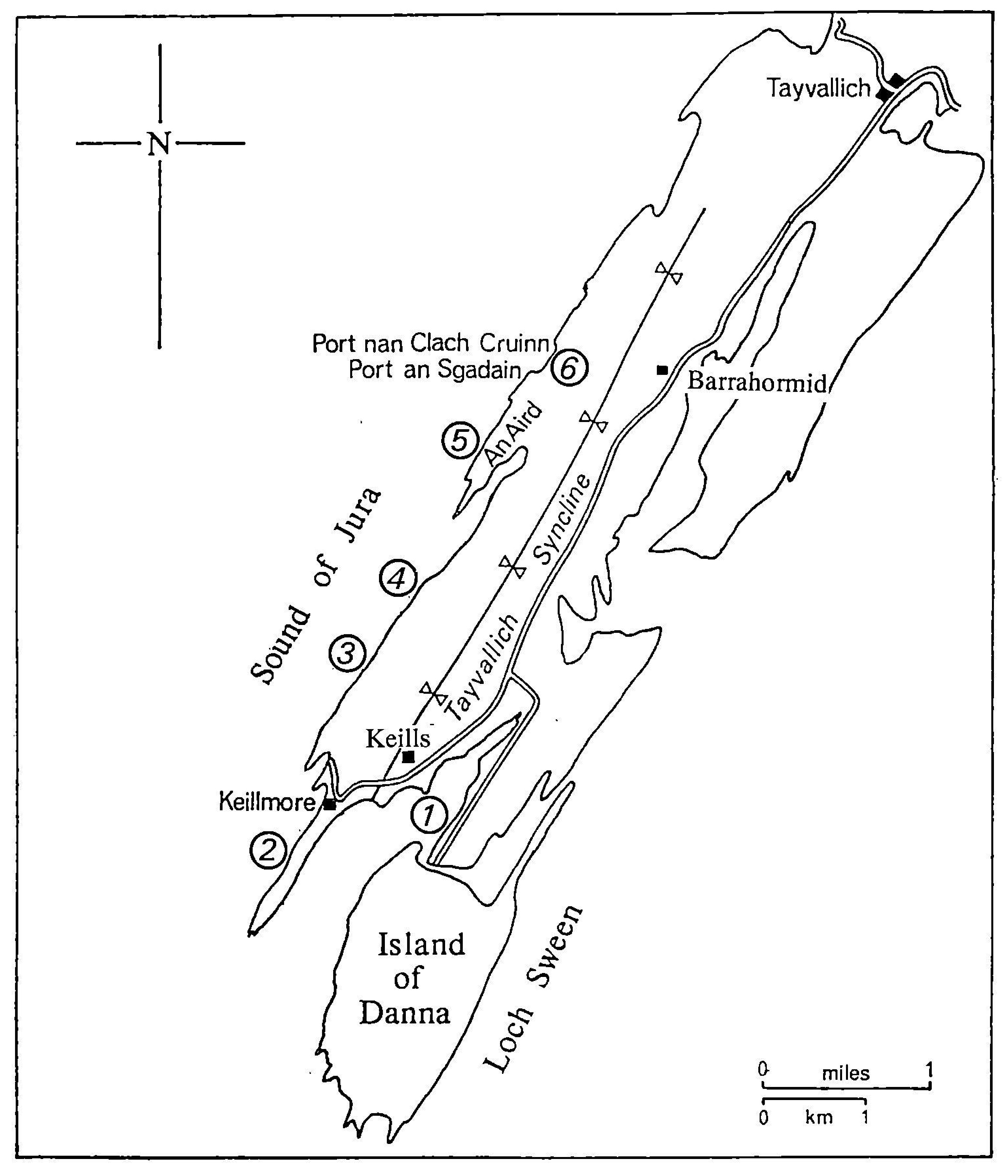
The excursion involves an all-day walk from Keills on the southern end of the Tayvallich Peninsula (Figure 6), northwards along the western coast on the west side of the Tayvallich Syncline, a SW continuation of the Kilchrenan (Loch Awe) Syncline. The distance is approximately 9 km, generally over rough coastal ground, and the area can be very exposed if the weather is bad. A detailed description of the geology of the Tayvallich Peninsula is provided by Gower (1977), on which much of the following itinerary is based.
3.2 The Tayvallich Volcanic Formation (Argyll Group)
The Tayvallich Volcanic Formation consists of up to 2000 m of basic pillow lavas, hyaloclastites and various epiclastic volcanic rocks, thinning rapidly to the NE (Borradaile 1973; Graham 1976). Some of the rocks have undergone extensive hydrothermal spilitisation, probably a sea-floor process that occurred soon after extrusion. The unspilitised lavas and sills have an evolved tholeiitic chemistry, with a complex differentiation history marked by evolution towards extreme enrichment in Fe, Ti and P and depletion in Ni and Cr. Trace-element characteristics have been described as intermediate between Mid-Ocean Ridge and within-plate (including continental) basalts (Graham 1976; Graham and Bradbury 1981; Graham and Borradaile 1984).
Extrusion of the main volcanic pile was clearly submarine, but away from the main volcanic centre (which corresponds to the axis of the Loch Awe Syncline) air-fall tuffs have been recognised. The whole sequence from the Craignish Phyllite upwards is intruded by up to 3000 m of metabasic sills. A suite of NW-trending metabasalt dykes on Jura may represent feeders for the lavas and sills (Graham and Borradaile 1984). The Tayvallich Volcanic Formation has been dated at 595±4 Ma, by U-Pb on zircons from a co-genetic keratophyre laccolith (Halliday et al. 1989).
The west coast of the Tayvallich Peninsula provides a continuously exposed strike-parallel section through pillow lavas, hyaloclastite breccias, tuffs massive lavas and volcaniclastic sedimentary rocks (Gower 1977). The rocks of the area are folded into a syncline (Tayvallich Syncline) and display a strong axial planar cleavage, plunging to the SSW. The pillow lavas are particularly well exposed at [NR 6930 8178] where individually they are up to 3 m by 1 m in size. Way-up is well defined by the pillow shapes relative to each other and concentrations of feldspar crystals (up to 1 cm long) at the pillow bases. Many of the pillows also display concentric bands of vesicles towards their tops.
3.3 Excursion itinerary
Drive southwards on the B8025 through Tayvallich to Keills (to avoid long return walk leave additional vehicle in layby just south of Barrahormid Farm [NR 717 839]. Park near jetty at Keills (note parking is very limited). Localities are shown in (Figure 6).
3.3.1 Locality 1: Keills jetty [NR 697 805]
Examine exposures on the shore along the high water line by Keills jetty. The lithology consists of fragments of vesicular lava and pillow fragments within a limestone matrix. These deposits may represent the leading edge of a submarine lava flow where lava fragments have broken off and been deposited within the surrounding unconsolidated sediment in a marginal shelf setting.
This locality is on the eastern limb of the Tayvallich Syncline, and the volcanic fragments are deformed and flattened within the main cleavage associated with this structure. The hinge has a moderate plunge to the SSW.
3.3.2 Locality 2: Keillmore [NR 688 803]
Walk westwards along the track past Keills chapel (NB. Excellent Celtic crosses and graveslabs!) as far as the gate for Keillmore. Cross the stile onto the southern part of the peninsula and walk c.200 m SW to a small wall just north of the brick huts. Proceed to the western shore. This is on the W side of the Tayvallich syncline, where the rocks dip uninverted very steeply to the ESE. Traversing from W to E, deformed pillow lavas stratigraphically underlie a distinctive breccia-conglomerate unit several metres thick. This is the Loch na Cille Boulder Bed.
The Loch na Cille Boulder Bed consists of fragments of felsite, syenite and epidiorite within an altered hyaloclastite matrix. The clasts in the boulder bed are highly altered and epidotised. It was originally described by Peach et al. (1911) as 'an extraordinary conglomerate....full of fragments of slaggy epidiorite, but also contains numerous pebbles of white felsite and syenite' They wrote that the matrix contains 'crystals of feldspar and strongly resembles a decomposed sheared porphyritic epidiorite full of carbonates'. Various origins have been postulated for the Loch na Cille Boulder Bed, including a glacial origin (Elles 1935) and a porphyritic lava flow incorporating xenoliths of acidic boulders (Allison 1941). However a more reasonable explanation may be a breccia resulting from a submarine fissure eruption and associated debris flows which has incorporated various associated lithologies.
The Loch na Cille Boulder Bed is overlain to the E by dark-coloured bedded calcareous volcaniclastic rocks, similar to those seen at Locality 1.
3.3.3 Locality 3: Port a' Bhuailteir [NR 689 813]
Return to the track and walk northwards past Keillmore, following the track into the fields. Continue north across the fields, then descend westward past the ruined farm building, walking to the gate at the W field boundary. Drop down onto the raised beach platform at Port a' Bhuailteir through the small gully by the fence.
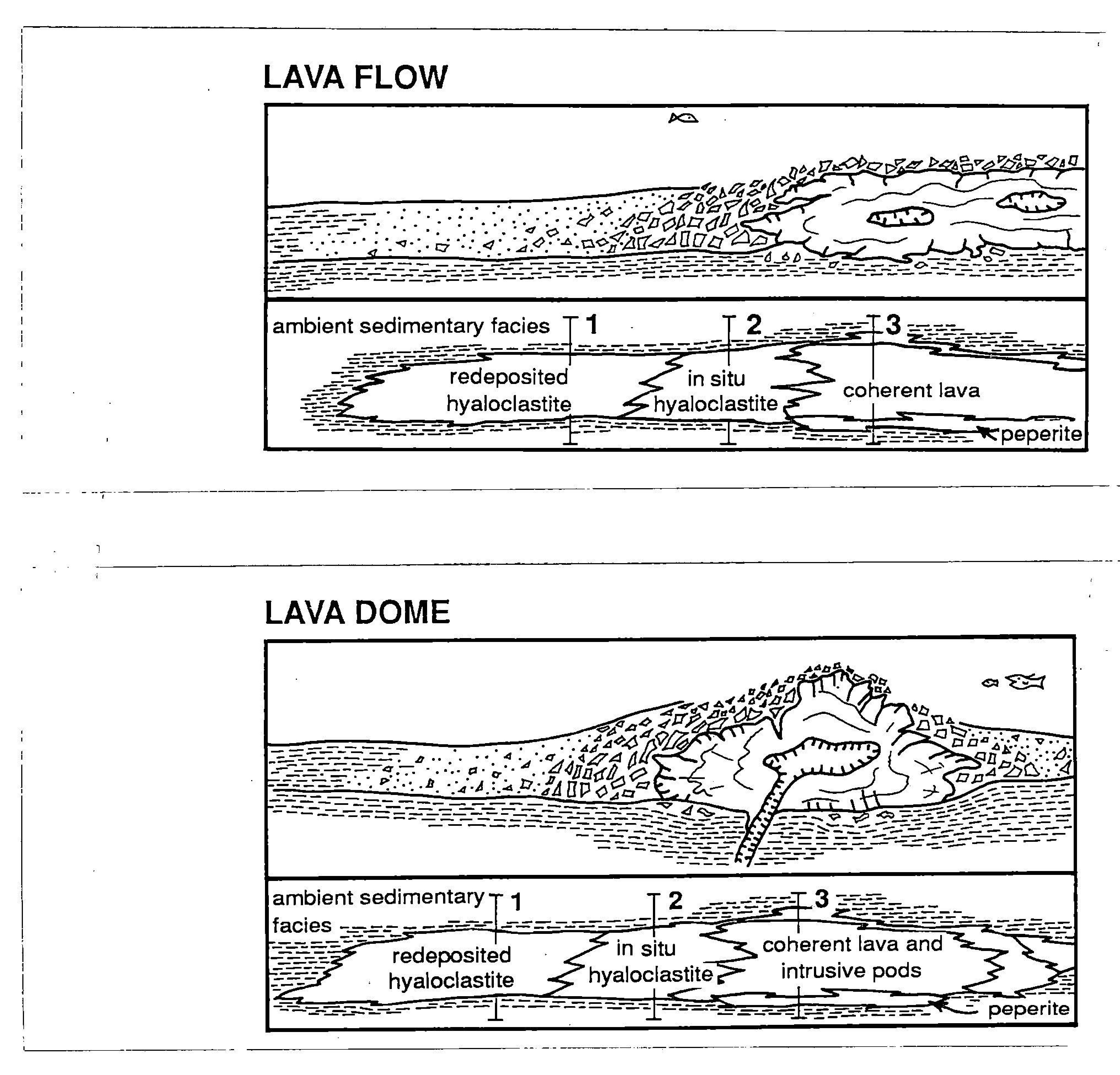
This section of shore contains extensive deposits of interpillow tuffaceous material and pillow lavas on the W side of the Tayvallich Syncline. These sequences are similar to the Butterlope Glen volcanics in the Sperrin Mountains in Northern Ireland which have been correlated with the Tayvallich Subgroup, although the Tayvallich rocks are less deformed. A series of well-bedded hyaloclastite tuffs are exposed, showing graded bedding with feldspar-rich bed bases younging towards the E. Sheared and brecciated pillow lavas are also exposed further along the shore. A schematic model for the formation of these deposits is shown in (Figure 7).
Continue N along the shore for c.150 m where a distinctive orange-coloured intrusion of 'porphyry breccia' (Peach et al. 1911) is exposed in a raised sea-cliff. It is composed of clasts of orange/pink porphyry up to c.60 cm in size within a grey-coloured tuffaceous epidiorite matrix. The intrusion is about 8 m wide at its thickest extent, thinning towards the north. It appears to represent an explosive volcanic intrusion which has fragmented a sub-volcanic porphyry deposit.
Continue northwards for several hundred metres through similar interpillow tuffs and pillow deposits to [NR 693 817] where immediately north of a small cove extensive exposures of pillow lavas are present. These pillow lavas show typical pillow morphologies, including way-up criteria, indicated by both pillow morphology and settling of feldspar phenocrysts to the pillow base. They also show characteristic concentric zoning and chilled margins.
Thin sections of the pillow lavas and associated volcaniclastics show that proximal volcaniclastics contain abundant clasts of plagioclase phenocrysts derived directly from the pillow basalts, with sheared-out mafic minerals now recrystallised to give trails of epidote. Clasts of basalts are also present, within a matrix of fine grained plagioclase, quartz and white mica-chlorite. It appears that much of the material in these rocks has been derived directly from the pillow basalts. More distal volcaniclastic samples contain lensoid clasts of feldspar and quartz within a matrix dominated by white mica-chlorite, carbonate and epidote.
3.3.4 Locality 4: 595Ma Quartz keratophyre [NR 695 822]
Continue N along the coast for about 400 m to an obvious large porphyry intrusion exposed in the intertidal zone. This is a small laccolith, representing one of a number of quartz keratophyres occurring within the Tayvallich Volcanic Formation. It is a pinkish-grey feldspar porphyry comprising large tabular albites up to 3 mm in length displaying 'chessboard' twinning, within a finer albite-rich matrix containing quartz, epidote, white mica, chlorite and opaques. Parts of the intrusion show a poorly developed mineral banding of alternating mafic and felsic layers parallel to the upper contact. The contact is concordant with the surrounding bedded volcanics, and a chilled margin is locally present. These quartz keratophyres have been interpreted as representing a more fractionated component of the Tayvallich volcanic suite.
It is from this quartz keratophyre that zircons have provided a U-Pb age of 595 ± 4 Ma (Halliday et al. 1989). This has been interpreted as representing the age of the Tayvallich Volcanics, and by implication indicating that most or all of the Dalradian Supergroup is Precambrian in age.
3.3.5 Locality 5: An Aird Peninsula [NR 704 838]
Continue northwards along the shore, past the obvious large quartz veins opposite the end of An Aird peninsula, noting the finely laminated volcaniclastic deposits (possible graded bedding?) containing distinctive large sulphides (pyrite). Walk past the ruined farm at Auchoshin and cross the mudflats onto An Aird peninsula. Walk S along peninsula to the prominent central ridge. The western side of the peninsula is composed of pillow lavas, gradually overlain to the E by pillow breccias and hyaloclastite tuffs. These are intruded by a prominent epidiorite laccolith which may have acted as a feeder for some of the overlying pillow lavas.
3.3.6 Locality 6: Port an Sgadain [NR 707 846] & Port nan Clach Cruinn [NR 709 848]
At these localities it is possible to examine the base of the Tayvallich Volcanic Formation and the underlying Tayvallich Limestone Formation. The lavas exposed here show interaction with the limestones and are characterised by rusty-coloured carbonate veins amongst large pillows which have pipe amygdales at their bases and a scoriaceous top.
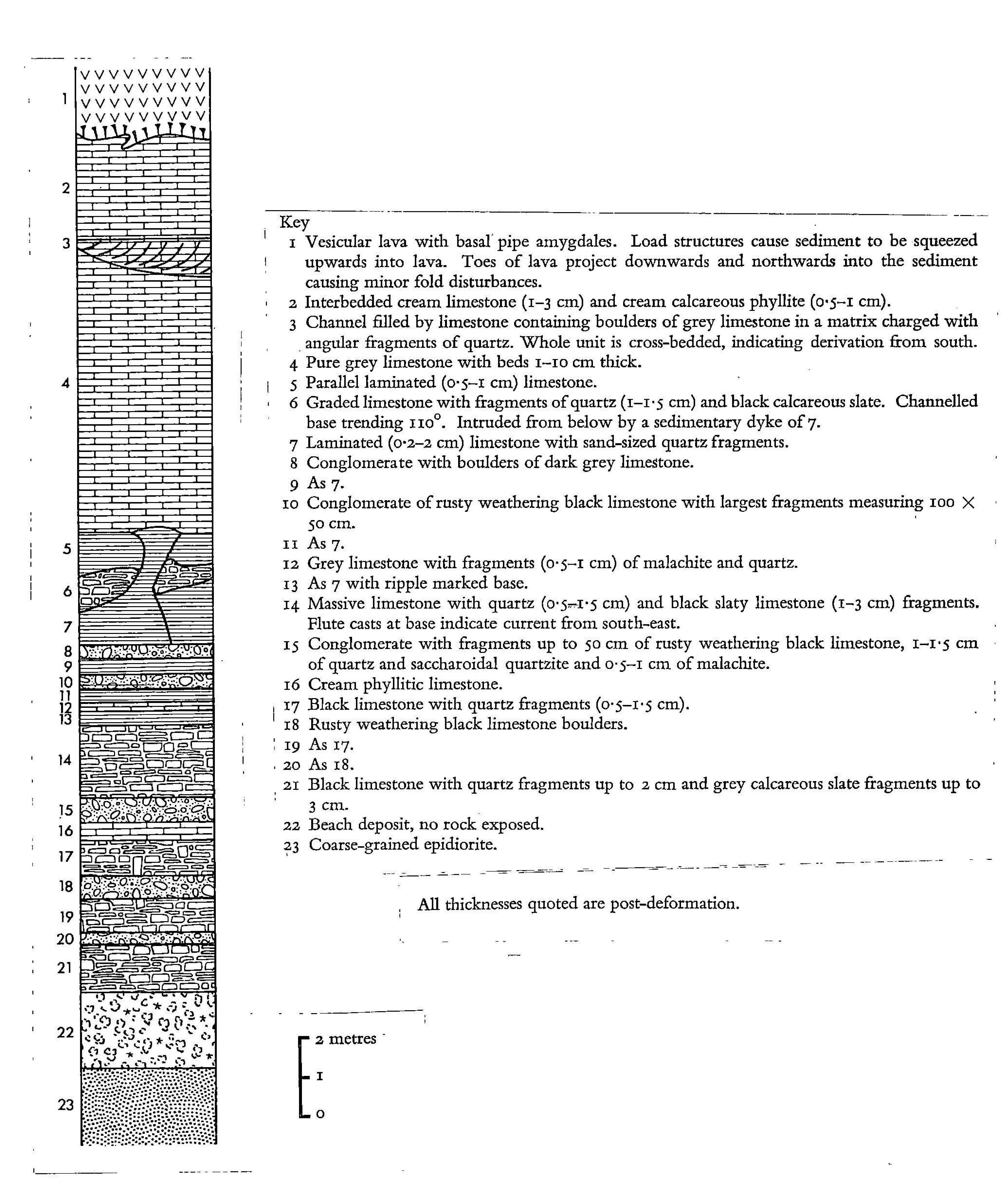
At Port an Sgadain large lobes of lava near the base of the formation can be seen pushing into the underlying Tayvallich Limestone Formation. Nearby to the north at Port nan Clach Cruinn coastal exposures in small cliff again expose the base of the Tayvallich Volcanic Formation. At this locality 'push folds' in the underlying calcareous phyllite have been described (Wood 1964), formed as the lavas advanced northwards and pushed forwards and downwards into the underlying soft sediments. In places isolated bulbs of lava have formed by downwards loading and detachment of lava. A stratigraphic facies log for this locality is shown in (Figure 8).
Return to the main road by walking eastwards over the hill, following the track NE of North Ardbeg, and descend to road S of Barrahormid farm.
4. Traverse between Loch Melfort and Loch Avich: stratigraphy of the uppermost Dalradian
4.1 Introduction
This excursion examines exposures of middle and upper Dalradian in the Loch Awe area; rocks from the Middle Argyll Group (topmost Easdale Subgroup) through the Crinan and Tayvallich Subgroups into the Southern Highland Group.
4.2 Background
4.2.1 Kilmelford/Loch a' Phearsain area
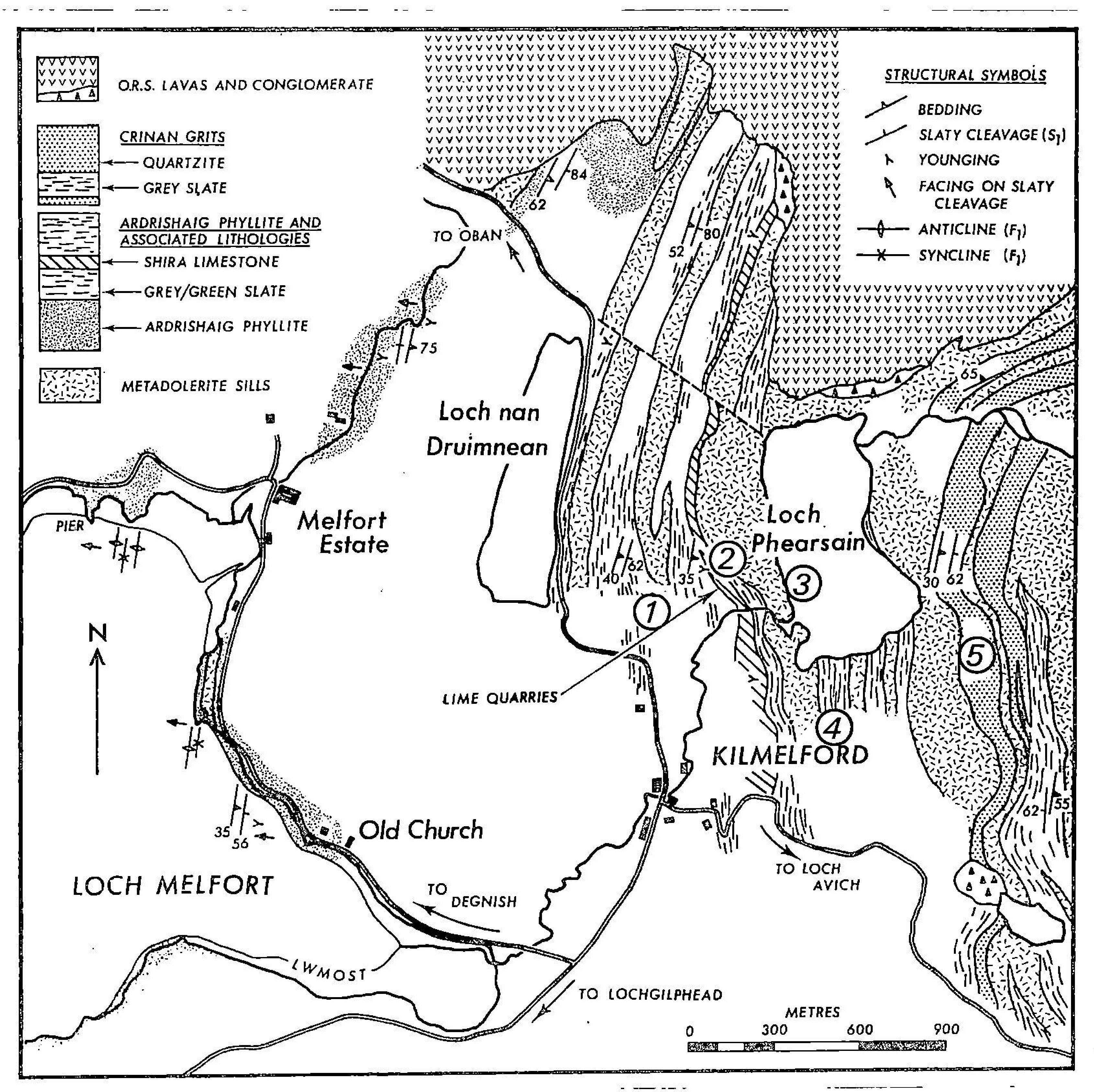
Examination of the geology of the area around Kilmelford/Loch a' Phearsain involves a traverse across strike from west to east within the middle Argyll Group, starting in the Ardrishaig (Craignish) Phyllite and Shira Limestone at the top of the Easdale Subgroup, and passing into the overlying Crinan Grits of the Crinan Subgroup (Figure 9). The sequence is extensively intruded by a series of metadolerite sills, interpreted as feeders to the overlying Tayvallich Volcanic Formation. The sequence has been described in detail by Borradaile (1977) from which much of the following is taken.
4.2.2 Loch Avich Lavas (Southern Highland Group)
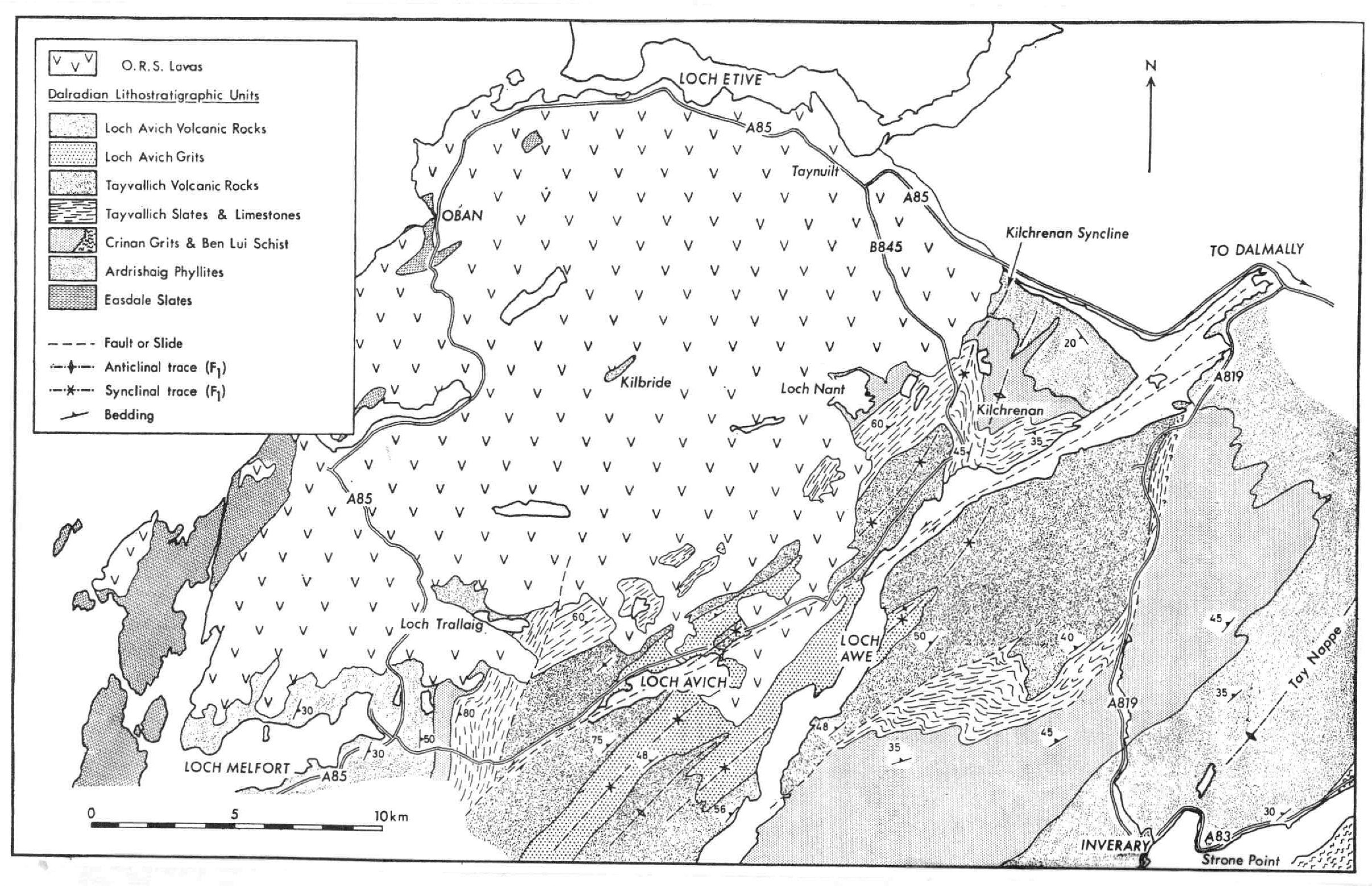
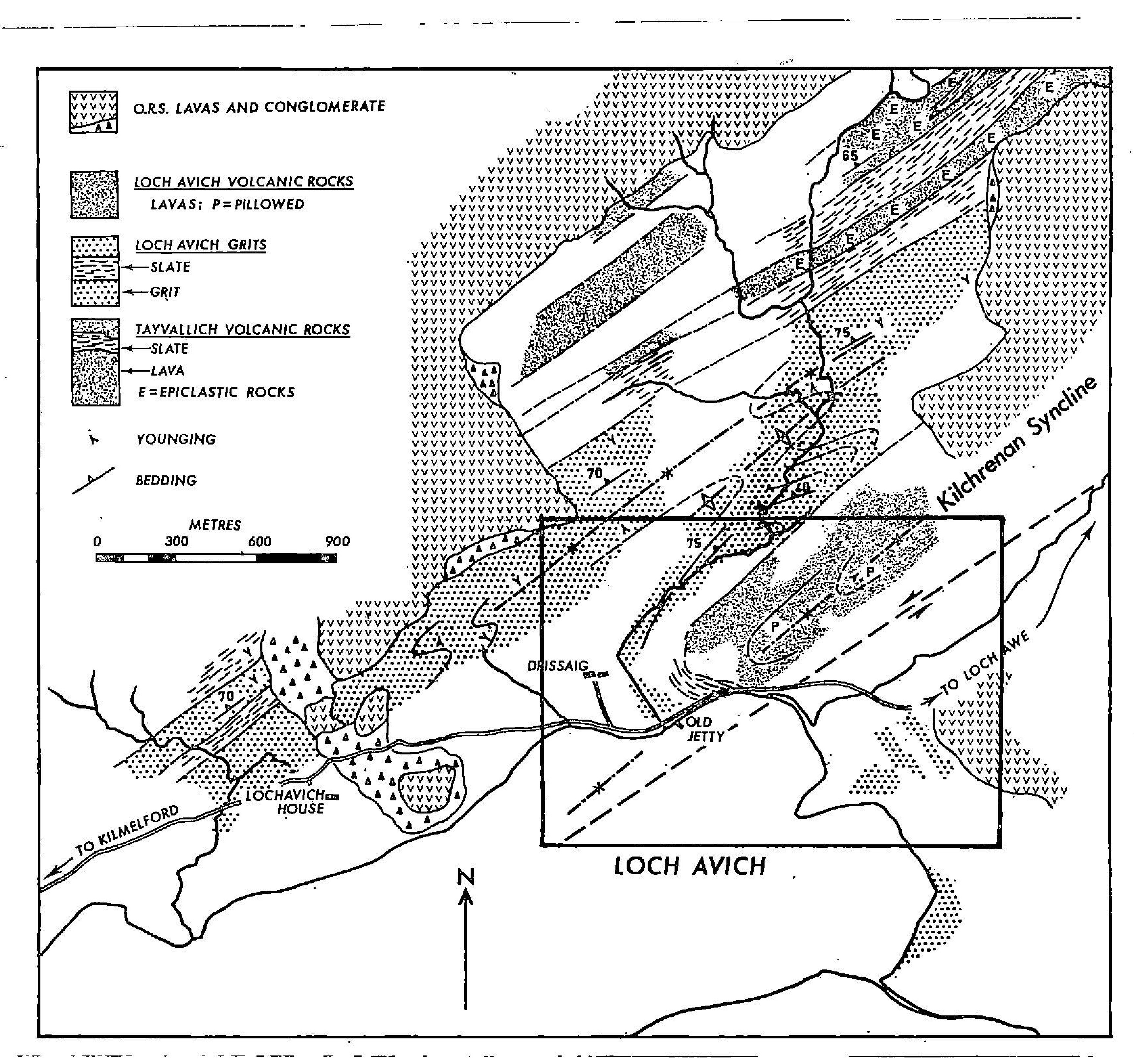
In the core of the Loch Awe Syncline (locally the Kilchrenan Syncline), the Tayvallich Volcanic Formation is overlain by up to 1100m of chloritic graded gritty psammites, green slates and subordinate black slates, which together make up the Loch Avich Grit (Stephenson and Gould, 1995). The overlying Loch Avich Lavas, which are preserved only in the core of the Loch Awe Syncline and crop out north of Loch Avich, consist of 300–500m of basaltic pillow lavas with no significant sedimentary intercalations (Borradaile 1973).
Borradaile (1973) described the Loch Avich Lavas as being more acidic than the stratigraphically lower Tayvallich lavas, from which they are separated by 650 m of sediment. Although no sills are seen to feed the Loch Avich Lavas, Borradaile (1973) suggested that they were fed by some of the sills that occur below the Tayvallich lavas. He interpreted the Loch Avich Lavas as being co-magmatic with the Tayvallich Volcanic Formation and its sill-feeders; the Loch Avich Lavas representing a new phase of submarine volcanism. Stephenson and Gould (1995) suggested that the Loch Avich Lavas represent a final phase of lithospheric stretching in the Dalradian Basin.
4.3 Excursion itinerary
Localities 1 to 5 are shown in (Figure 10).
4.3.1 Locality 1: Ardrishaig Phyllite [NM 851 136]
Drive north through Kilmelford on the A816, and park in layby/field entrance on E side of road approximately 0.5 km N of Kilmelford, before Loch nan Druimnean. Walk though the gate and go to the NE corner of field. Continue into the next field along the northern boundary with the forestry plantation to the track and forest entrance. Examine the new exposures on the E side of the track where micaceous semipelitic metasediments of the Ardrishaig Phyllite are intruded by a metabasic sill. Various exposures of Ardrishaig Phyllite show ripple cross bedding and facing on slaty cleavage which is upwards to the west.
4.3.2 Locality 2: Shira Limestone [NM 851 136]
Enter through the forest gate and walk E along the path at the forest edge to the disused limekiln. Directly to the north in a small clearing are two small quarries which expose Shira Limestone (now rather overgrown). Although only 5–10 m thick in this area, the Shira Limestone is recognised as a persistent marker horizon at the top of the Ardrishaig Phyllite. The limestone is described as black in colour, sandy and brecciated (Borradaile 1977).
4.3.3 Locality 3: Metabasite [NM 853 136]
Continue eastwards along the path towards the waterfall. A large metabasite body several hundred metres thick is present where the path steepens, forming the prominent ridge along the western side of Loch a' Phearsain. Good exposures of metabasite can be examined along the pathway.
4.3.4 Locality 4: Ardrishaig Phyllite and metabasic intrusions [NM 854 134]
Continue along the path to Loch a' Phearsain, then walk southwards around the loch, crossing the stepping stones across the burn which flows out of the loch. Small patchy exposures of phyllites and metabasic intrusions are present around the southern edge of the loch. Follow the footpath around to a gate at the SE corner of the loch, immediately east of the island, examining the sequence of metabasic sills and host phyllites. The hillside to the east and south of the loch contains several prominent ridges formed by a series of metabasite sills. Farther to the north lies an extensive area of ORS lavas.
4.3.5 Locality 5: Crinan Grit [NM 859 136]
Go through the gate and follow the path up the ridge to the wall near the ruined farmhouse. This ridge is formed by the top of a metabasite sill. The flat boggy ground above the ridge is the base of the overlying Crinan Grit, comprising distinctive pale grey siliceous grits. Well exposed grits in the adjacent hillside show thick bedded units with graded bedding and cross-bedding (right-way-up) with distinctive cleavage refraction through different beds.
Return to the waterfall and descend down to the water tanks, cross the river and walk back across the fields to the vehicles.
4.3.6 Locality 6: Loch an Losgainn Mor [NM 868 121]
Drive south into Kilmelford and turn eastwards along the single track road to Loch Avich. Drive to Loch an Losgainn Mor and continue past the fish cages and park near the bend before the prominent peninsula on the opposite side of the loch. The road cuttings expose dark coloured slates and limestones of the Tayvallich Slate and Limestone Formation. These are typically dark phyllites which overlie the Crinan Grits, and form the base of the Tayvallich Subgroup.
4.3.7 Locality 7: Lagalochan (Tayvallich Volcanics) [NM 877 116]
Continue driving eastwards for approximately 0.5 km to a large new road cutting on the north side of the road, above the small abandoned farm of Lagalochan. The roadcut exposes the Tayvallich Volcanic Formation; here a typical intrusive complex with a mixture of various metabasic sheets, some of which may also represent much younger intrusions. The rocks here are very steeply inclined, and lie on the NW side of the Kilchrenan (Loch Awe) Syncline.
4.3.8 Locality 8: Duaig Farm (Loch Avich Grits) [NM 912 136]
Drive eastwards to the western end of Loch Avich. Stop in small passing place on N side of road just past entrance to Duaig Farm. The Loch Avich Grits can be examined in the small roadcut. These are typically feldspathic grits with dark slates. The grits are well bedded with graded bedding and possible rhythmic 'Bouma' type cycles.
4.3.9 Locality 9: Drissaig (Loch Avich Lavas) [NM 954 158]
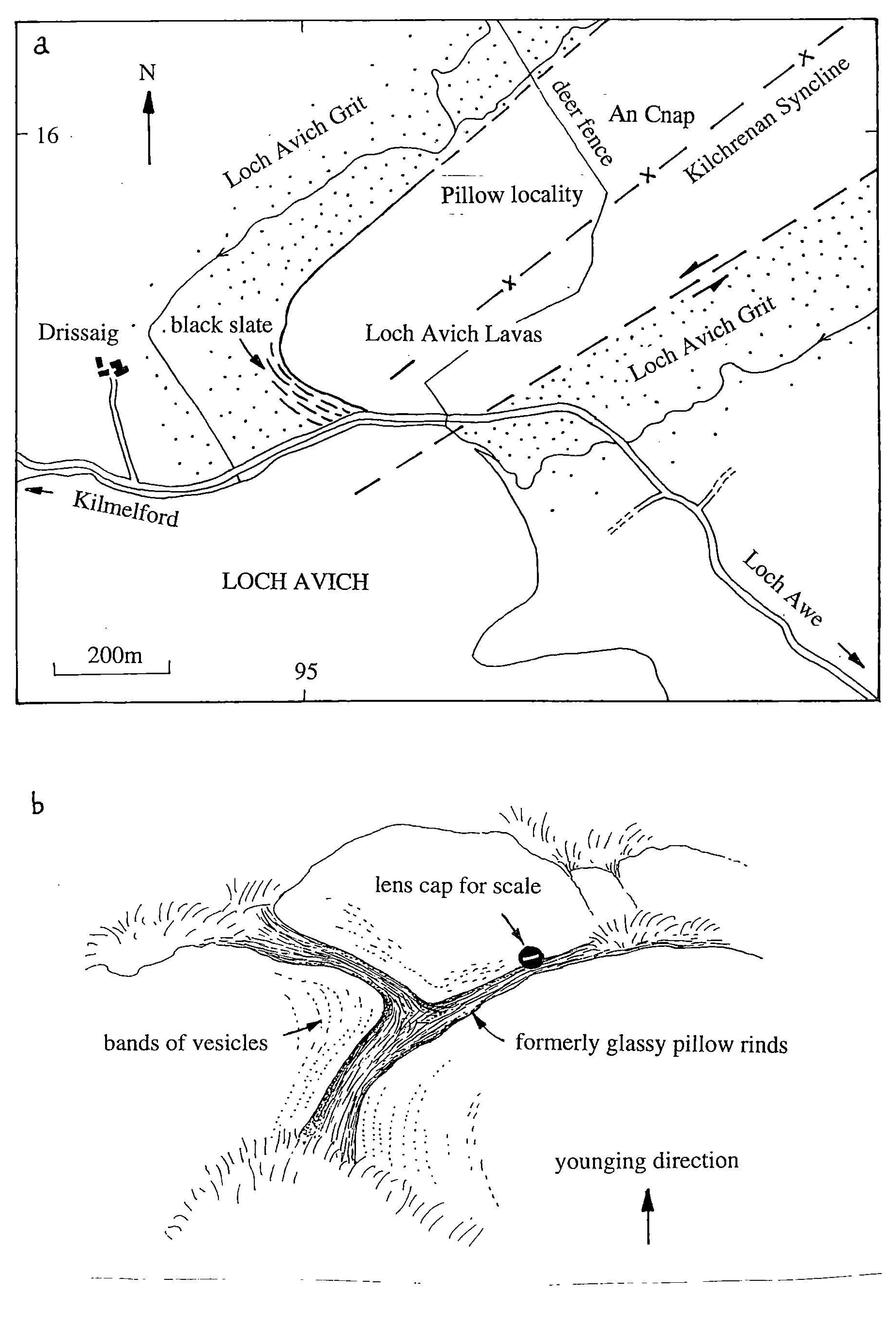
Drive to the eastern end of Loch Avich, past Drissaig Farm. Park east of the cattle-grid (possible parking place on south side of road near fishing boats). Walk back along the road to small track just east of the farm and climb up towards the rocky hill of An Cnap. Follow the track up through a small natural wood towards the top of the hill. On the lower summits west of the deer fence there are excellent exposures of pillow lavas. The geology of this area is shown in (Figure 11).
The Loch Avich Lavas outcrop as several rocky knolls NE of the farm of Drissaig (Figure 12). The total width of outcrop has been mapped as up to c. 500 m (Borradaile 1973). Well-preserved pillow lavas are observed in the central part of the outcrop area. The pillows are 1–1.5 m wide and are separated by 5 cm-thick rims of formerly glassy pillow rinds (Figure 12). The asymmetric pillow shapes indicate that they are the right way up. Several pillows display concentric rims of vesicles, which have been infilled by quartz in places, producing a 'gritty' appearance. The lavas are fine grained and pale buff to light greenish-grey in colour. Many display a foliation, especially away from the central part of the area of outcrop.
Continue to drive east, turning west along the north shore of Loch Awe, and rejoining the A816 at Carnassary Castle, c.15 km north of Lochgilphead.
5. The geochemistry of the Green Beds and associated Dalradian meta-igneous suites
5.1 Introduction
In addition to field-based mapping and research a major aspect of the Southern Highlands Project has been the establishment of an extensive geochemical database relating to the volcaniclastic Green Beds and associated metasedimentary and metabasic rocks within the upper Dalradian. The main aims of studying the geochemical data from this suite of rocks are to investigate the nature and origin of the Green Beds and also, using the geochemistry of the igneous rocks in particular, to shed light on the tectonic setting and evolution of the upper Dalradian as a whole.
An initial study was carried out using data sets from the literature (mainly from the 1960s to early 1980s; see Pickett 1997 for details of data sources). This was used as a basis for collecting further samples from both known and new locations, and also the re-analysis, using modern equipment and techniques developed at Edinburgh University, of existing samples from the collections of the BGS and Colin Graham (Edinburgh University).
The current Dalradian database includes XRF whole-rock major and trace element analyses for about 270 samples plus additional ICPMS rare earth element (REE) analyses for 33 of the samples. (REE analysis has also been carried out on a separate range of samples from across the whole Scottish Dalradian as part of a BGS Nd isotope traverse — see section 5.4). The database includes analyses of Green Beds and associated 'background' metasedimentary rocks ranging from Glen Clova in the E Grampians through the Scottish Southern Highlands to the Sperrin Mountains in N Ireland. Metabasic igneous rocks from this area are also represented, including metabasic intrusions and lavas from Ben Vrackie (near Pitlochry), Tayvallich, Loch Avich, Jura and N Ireland. The database also includes recent unpublished geochemical analyses of sills from Kilmelford and Islay which have been provided by Mike Norry (Leicester University). A further 30 analyses of Green Beds, metabasic intrusions and metasediments from N Ireland were obtained as a result of a collaborative research project between the BGS and GSNI, Belfast (funded by the Department of Economic Development, Northern Ireland).
5.2 Classification, variation and discrimination diagrams
In the following section the Green Beds, along with associated basic igneous and metasedimentary rocks are plotted on various igneous classification, variation and discrimination diagrams. Although the majority of these plots are designed for primary igneous rocks the high proportion of volcanic material in the Green Beds means that their plotting positions are significant in terms of igneous classification fields and also allow comparison with associated primary igneous rocks. Data for 'background' metasedimentary rocks are also included on some plots for comparison purposes.
5.2.1 Igneous classification diagrams
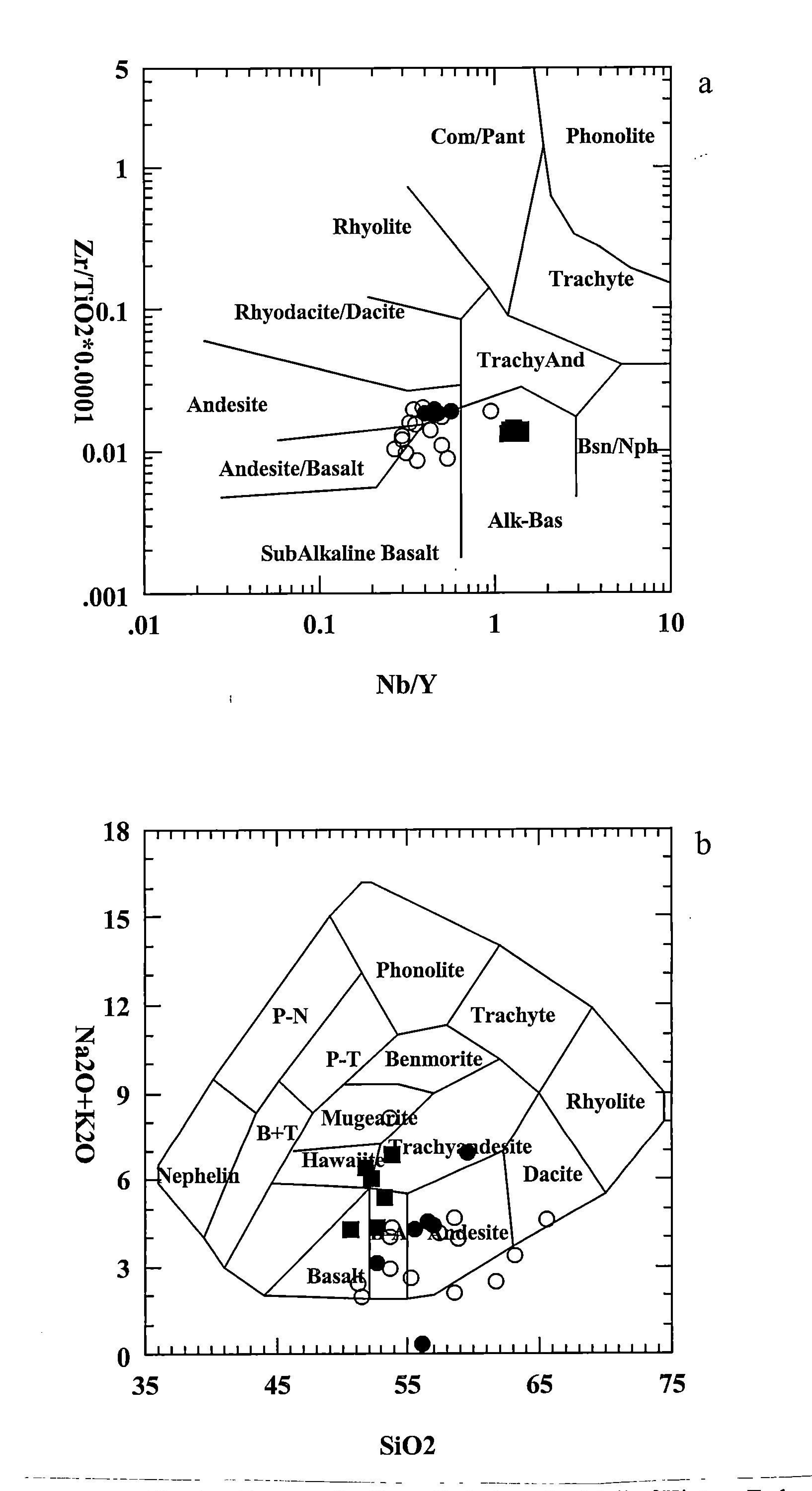
Owing to their high proportion of fine-grained volcanic-derived material the Green Beds display basic compositions. The igneous classification diagrams in (Figure 13)a and b clearly demonstrate the generally basic-intermediate composition of the majority of Green Beds, confirming the high proportion of basic volcanic, as opposed to siliciclastic, material that they contain. Tayvallich and Loch Avich lavas are also shown. In (Figure 13)b the wide range of silica compositions probably reflects sedimentary mixing with siliciclastic material rather than igneous processes. However, the plot does show that the most 'basic' Green Beds lie within the basalt field. (Figure 13)a in particular also highlights the different compositions of the Tayvallich and Loch Avich lavas.
5.2.2 Variation diagrams
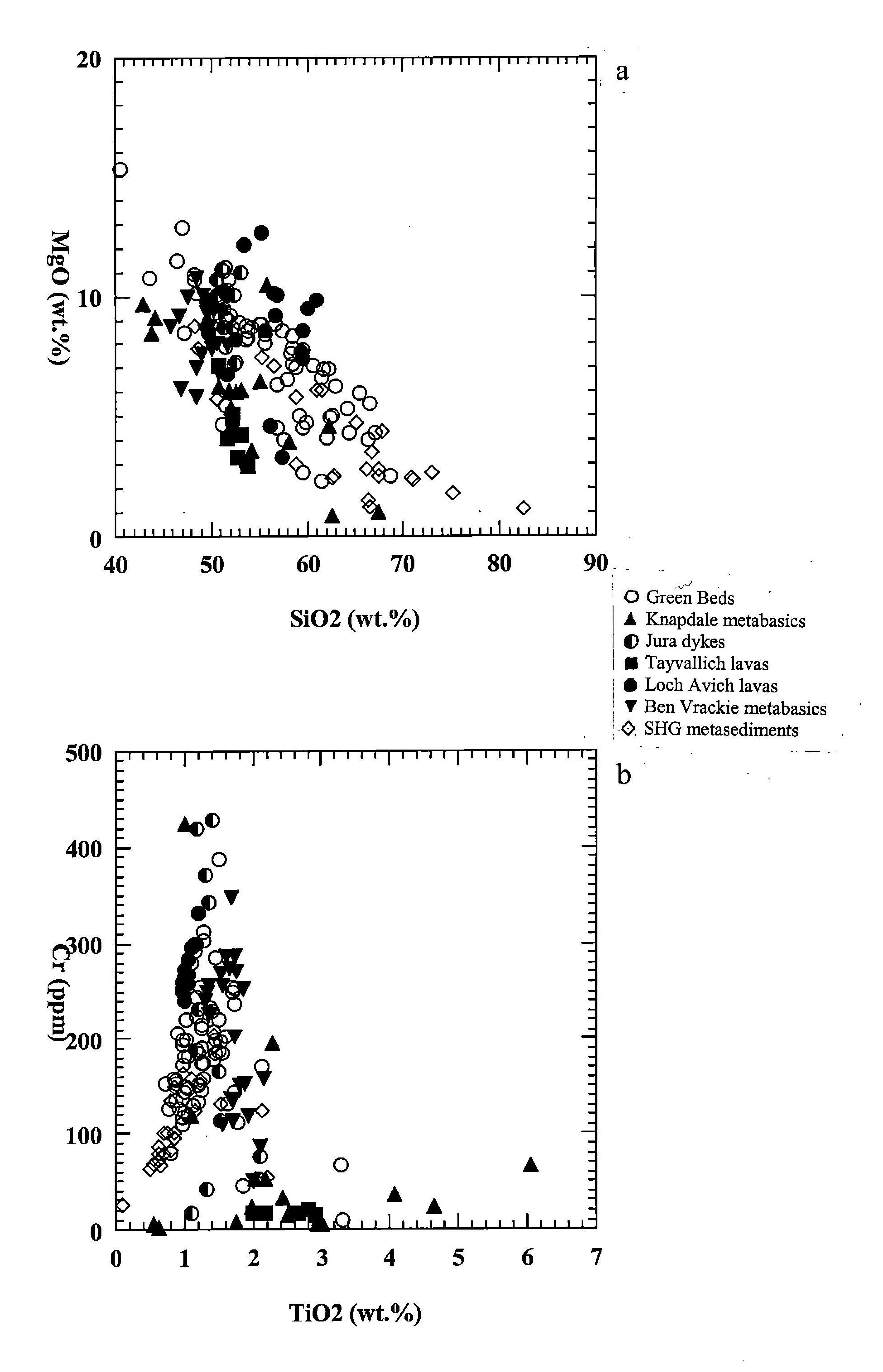
The MgO-SiO2 variation diagram ( (Figure 14)a) shows a wide range of compositions for the Green Beds, ranging from high MgO-low SiO2 (i.e. volcanic-rich) to low MgO-high SiO2 (i.e. siliciclastic-rich), reflecting the degree of 'contamination' by detrital siliciclastic material. The more 'basic' Green Beds cluster with basic igneous rock types in the low SiO2 region of the plot while in the high SiO2 area of the plot the more siliciclastic Green Beds compositionally overlap with the Southern Highland Group psammites. Variation in MgO is also quite marked and may reflect different degrees of differentiation in the igneous rocks and sedimentary mixing in the Green Beds. A few Green Beds contain significantly less SiO2 than the Tayvallich or Loch Avich pillow lavas or many of the metabasic intrusions. The Cr–TiO2 diagram (Figure 14)b also shows the majority of the Green Beds lying along a trend which reflects the range of compositions between 'basic' and 'siliciclastic' compositions. At the low Cr, low TiO2 end of the trend the Green Beds compositionally overlap with 'background' psammites. The 'basic' end of the Green Bed trend lies close to the plotting positions of Jura dykes and metabasic sheets from Ben Vrackie. This plot also highlights the very different compositions of the Tayvallich and Loch Avich lavas and also suggests that the Tayvallich lavas at least seem unlikely to represent a source of Green Bed volcanic material.
5.2.3 Sedimentary mixing
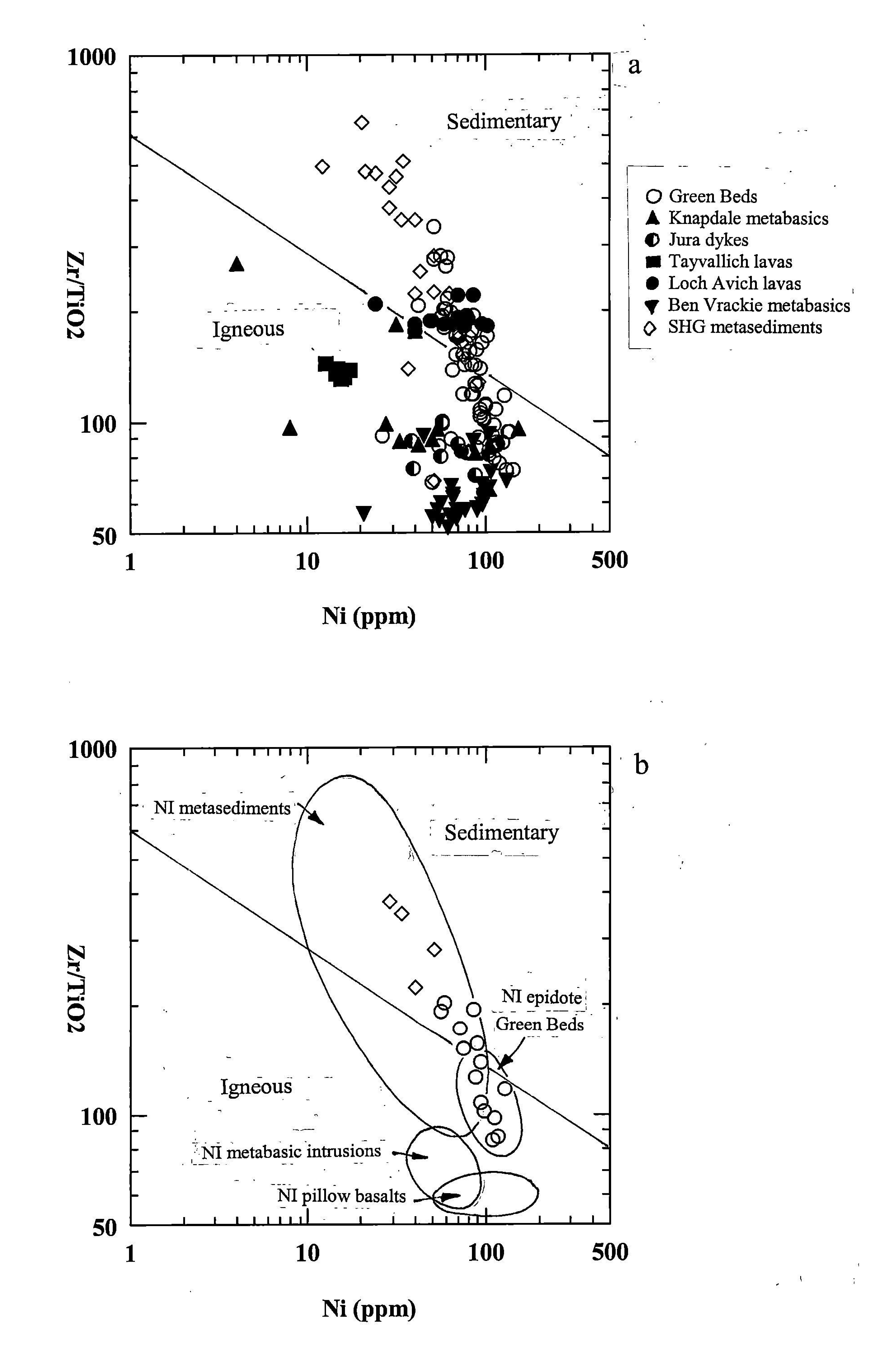
Recent work (e.g. Pickett 1997, Hyslop and Pickett 1998) suggests that the Green Beds comprise, in varying proportions, a mixture of volcanic and detrital siliciclastic material. This characteristic feature is particularly well illustrated by the Zr/TiO2-Ni discrimination plot (Figure 15) which was designed for metavolcaniclastic rocks and broadly separates primary igneous rocks from those with sedimentary origins ('igneous' and 'sedimentary' fields after Goodman and Winchester 1993). (Figure 15)a shows Green Beds, Southern Highland Group background metasedimentary rocks and various basic igneous suites from the Southern Highland and Argyll Groups. The Green Beds lie along a clear trend which straddles the igneous/sedimentary field boundary and may define a mixing trend between basic igneous and sedimentary end-member compositional fields (see also section 5.2.2 above). This mixed nature is confirmed by petrological analysis of thin sections where volcanic-derived material (e.g. chlorite, epidote, amphibole) and detrital siliciclastic material (e.g. quartz, feldspars, detrital heavy minerals) are both observed. The 'sedimentary' end of the Green Bed trend overlaps with the field of Southern Highland Group metasedimentary rocks (mainly psammites) indicating a gradational suite of Green Bed compositions ranging from siliciclastic-poor to siliciclastic-rich.
Many upper Dalradian metabasic sheets (e.g. those from Knapdale, Jura and Ben Vrackie) lie close to the 'basic' end of the Green Bed mixing trend and may represent end-member compositions (i.e. potential sources?) for the Green Beds' volcanic component. However, it is interesting to note that the Tayvallich and Loch Avich pillow lavas (from the upper Argyll and Southern Highland Groups respectively) which would seem to be obvious candidates for Green Bed sources form distinct compositional clusters well away from the 'basic' end of the Green Bed mixing line.
(Figure 15)b shows selected data for Green Beds and background metasediments from the Mull of Kintyre-Tarbert-Loch Fyne area (i.e. the general area visited during this excursion) in relation to data for similar upper Dalradian suites in Antrim and the Sperrin Mountains in N Ireland. Pillow lavas and metabasic intrusions from N Ireland lie close to the more basic Green Beds and may also represent potential igneous end-member compositions. Note the similarity between N Irish igneous rocks and those from Ben Vrackie and Jura.
5.2.4 Tectonic discrimination diagrams
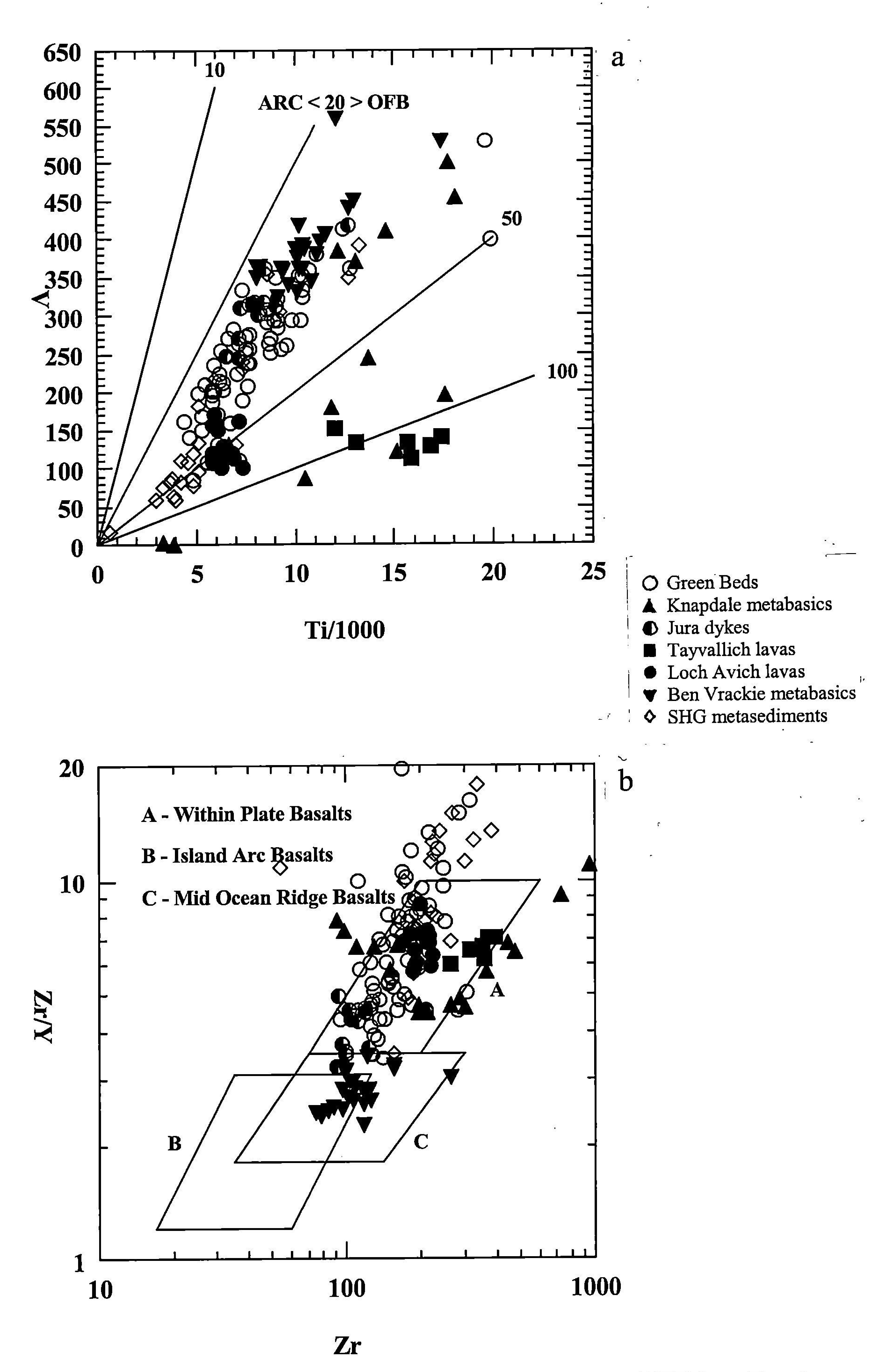
On the V-Ti tectonic discrimination diagram (Figure 16)a all samples plot in the Ocean Floor Basalt (OFB) field, confirming their non-arc related origin. The term 'Ocean Floor Basalts' can include Mid Ocean Ridge Basalts (MORB) or a variety of Within-Plate Basalts (WPB) from oceanic (e.g. seamount) or intracontinental (e.g. extensional rift) settings. Further discrimination is provided by (Figure 16)b which suggests a range of MORB to WPB affinities for the Scottish Dalradian basic rocks. The Green Beds lie predominantly in the within-plate field, along with the Loch Avich and Tayvallich Lavas. The Jura dykes lie in an intermediate MORB-WPB position while the Ben Vrackie metabasic sheets lie firmly within the MORB field. Note that the presence of the background metasedimentary sample data is for information only, and is not applicable to these discriminant fields. Discrimination diagrams such as these should be used with caution as rock suites can plot in different fields on different diagrams. However, a preliminary inspection of the broad data patterns suggests an overall WPB (transitional to MORB?) setting for the bulk of the Dalradian igneous suites. More detailed characterisation techniques are described in the next section.
5.3 Geochemistry of upper Dalradian basic rocks in relation to mantle plumes
Given that the Green Beds comprise a mixture of volcanic and elastic material it is important that the various basic igneous rocks within the Southern Highland and Argyll groups are geochemically investigated in order to provide an indication of the possible source(s) of the Green Beds volcanic component. A study of the chemistry of these igneous suites will also be invaluable in the wider scale study of the tectonic setting and evolution of the Dalradian succession. The information could be used to test models such as that proposed by Soper (1994), who suggested that the Dalradian was deposited at the site of a triple rift junction, a setting which suggests the involvement of a mantle plume. Plume magmatism is currently being studied at the universities of Edinburgh and Leicester (e.g. Fitton et al. 1997). By comparing the geochemical signatures of Dalradian basic magmatism and known plume-related lavas such as those from Iceland it is hoped to gain insights into the tectonomagmatic setting of the Dalradian lavas and, if a plume is involved, how it may have controlled Dalradian sedimentation and tectonics.
Research at the universities of Edinburgh and Leicester (e.g. Fitton et al. 1997) has revealed significant geochemical patterns exhibited by the immobile elements Y, Zr and Nb in magmas produced by the mantle plume which operated during the opening of the NE Atlantic and which currently lies beneath Iceland. It has been found that magmas derived from mantle which normally melts to produce MORB contain considerably less Nb than magmas derived from mantle which melts to produce Ocean Island Basalt (OIB) (i.e. from mantle plumes). In the light of Soper's (1994) triple rift suggestion it is useful to compare the immobile element patterns of the Dalradian lavas with those of known plumes such as the Iceland example. Preliminary analyses of a suite of sills from Islay and Kilmelford (Norry, unpublished data) do suggest elevated Nb levels, thus providing some evidence, albeit preliminary as yet, for involvement of a mantle plume.
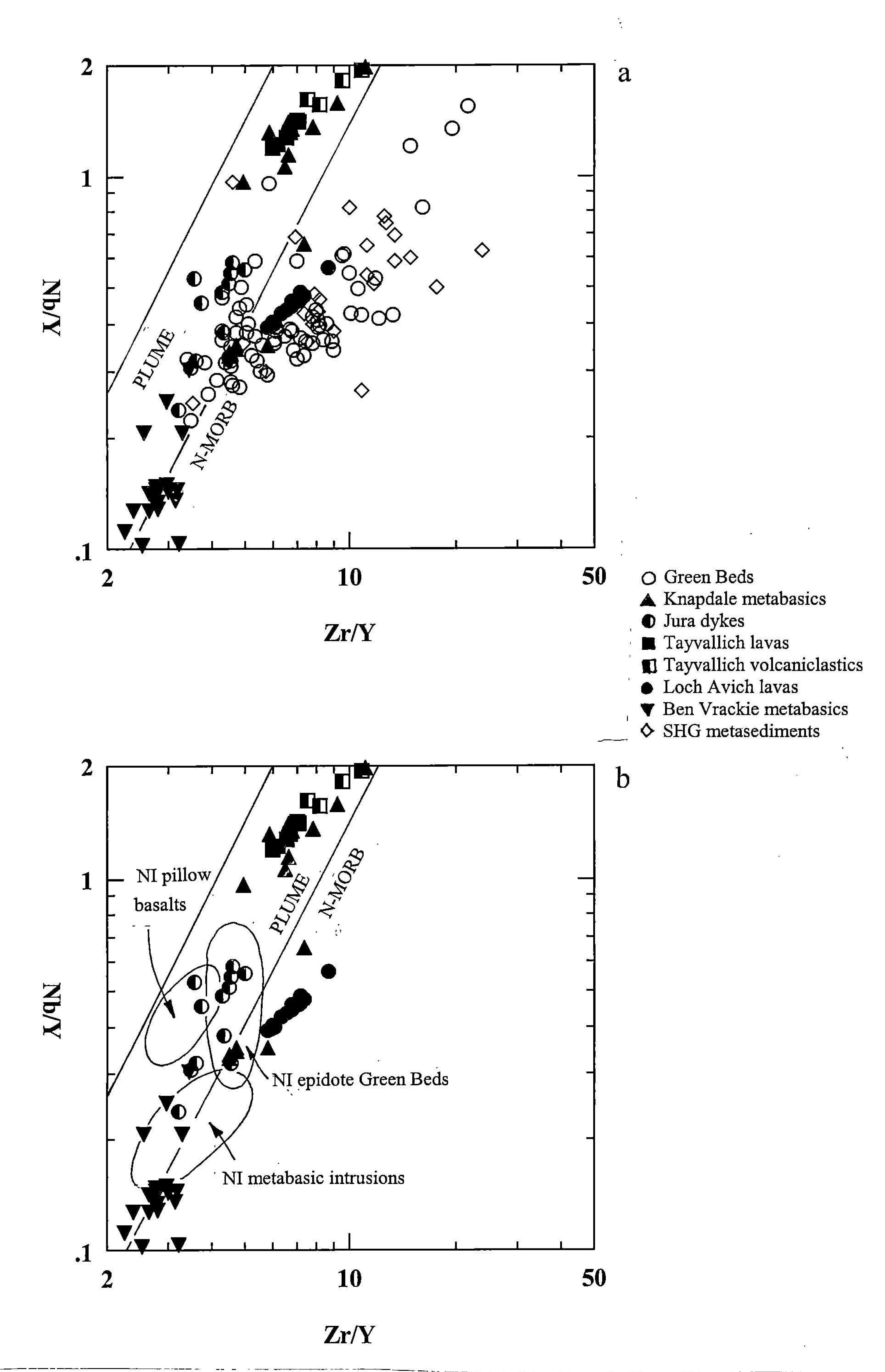
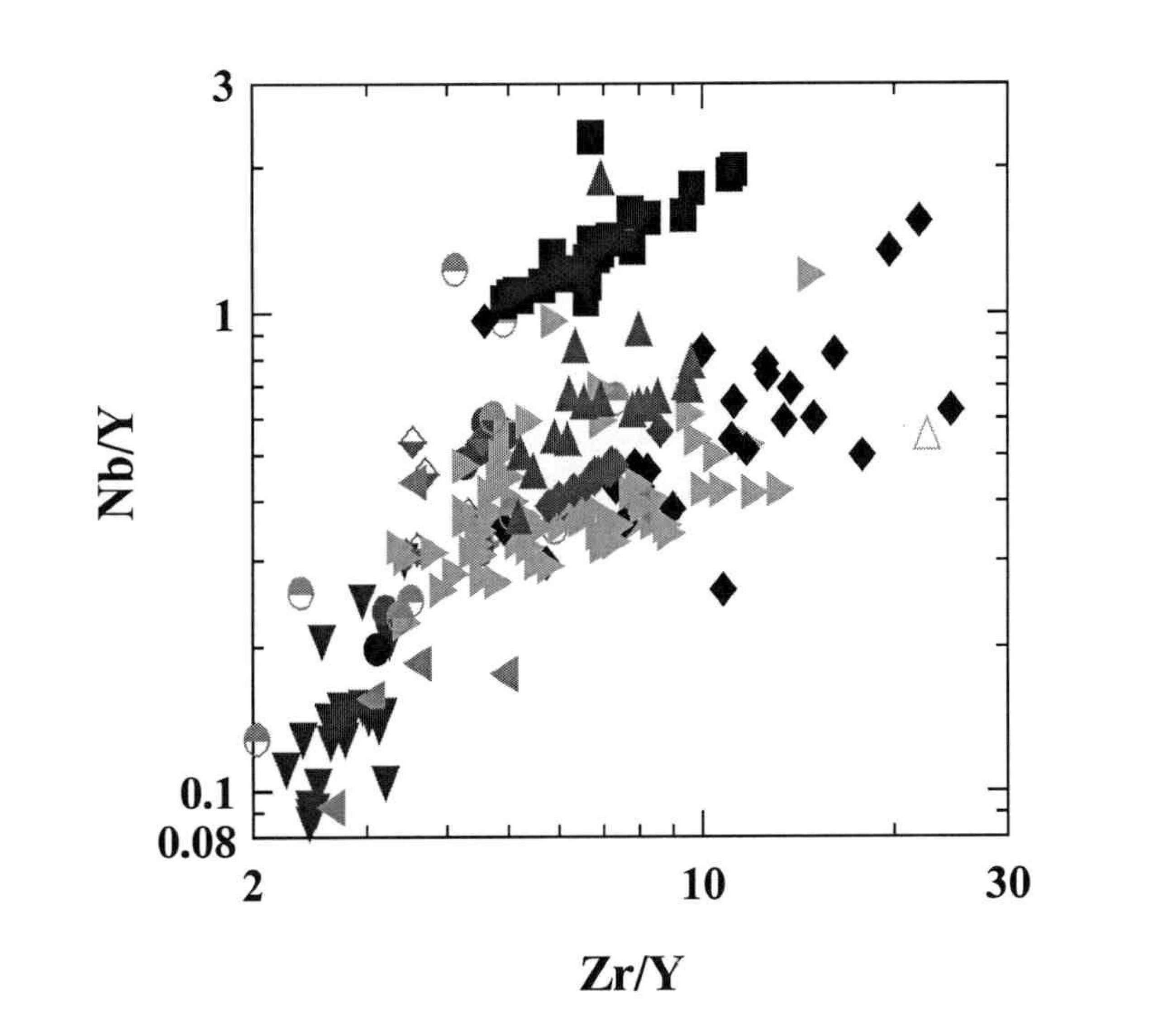
(Figure 17)a shows the variation in Nb/Y and Zr/Y of the Green Beds and various basic volcanic rocks and intrusive rocks from the Upper Dalradian of Scotland. The parallel lines define the array of plume-related Icelandic basalts (Fitton et al. 1997). Normal-type MORB (N-MORB) data are relatively deficient in Nb and form a linear array lying below and parallel to the Iceland data. Fitton et al. (1997) demonstrate that this plot is a robust discriminant between basaltic samples with Icelandic (i.e. plume-derived) and N-MORB mantle sources. For clarity the Green Beds and background metasediments have been removed from (Figure 17)b which shows the Scottish igneous suites in relation to fields of selected Dalradian rocks from N Ireland.
The plots show that, with the exception of the Loch Avich Lavas and some of the Ben Vrackie metabasic sheets the majority of the igneous rocks lie within the Icelandic 'plume' array c.f. (Figure 16)b. In particular, the Tayvallich lavas/Knapdale metabasic intrusions and the Jura dykes lie firmly within the plume field. The Loch Avich lavas appear to be N-MORB related and the Ben Vrackie rocks are transitional between plume and N-MORB. The Scottish Green Beds form a large cluster which straddles the plume/N-MORB boundary. Green Beds from N Ireland also lie in similar position although slightly towards the plume end of the Scottish Green Bed cluster. Interestingly, the N Ireland pillow basalts also lie at the plume end of the Scottish (and N Irish) Green Bed cluster, suggesting a possible close genetic relationship between these volcanic rocks and the Green Beds of both regions. Although the Tayvallich pillow lavas also lie within the plume array they form a distinctly separate cluster. This could reflect a different magmatic origin or it is possible that they form a different part of a fractionation trend from the N Ireland pillow basalts. The N Ireland metabasic intrusions lie in a position close to the plotting areas of Scottish metabasic sheets from Ben Vrackie. It should be noted that samples from the Icelandic plume plot along almost the entire plume array, so that even although particular Scottish and N Irish volcanic suites may plot in different parts of the diagram, this does not rule out the fact that they could have formed within the same tectonic system.
5.4 Rare earth element (REE) data for Dalradian basic igneous and sedimentary rocks (contribution by Mike Petterson)
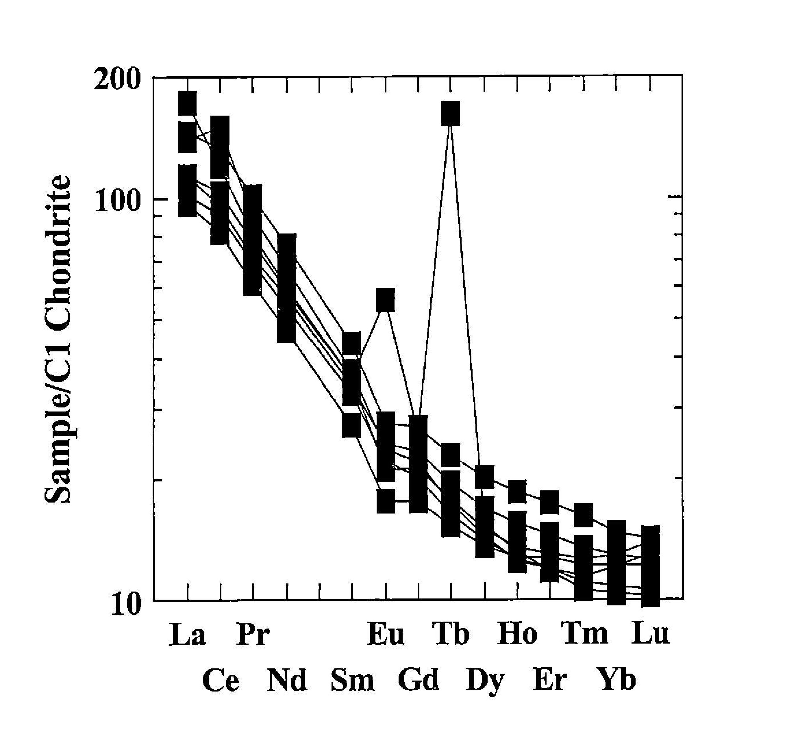
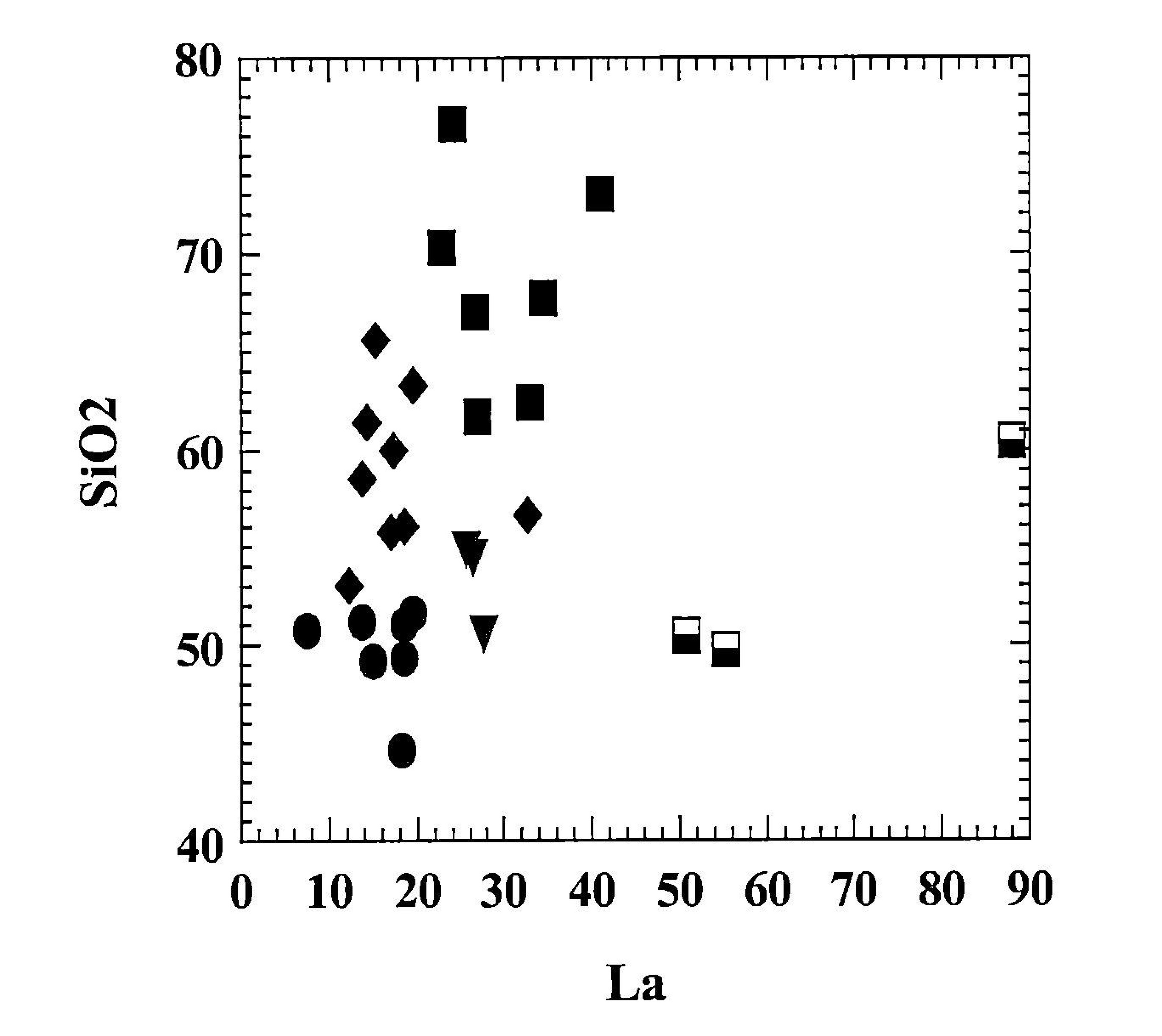
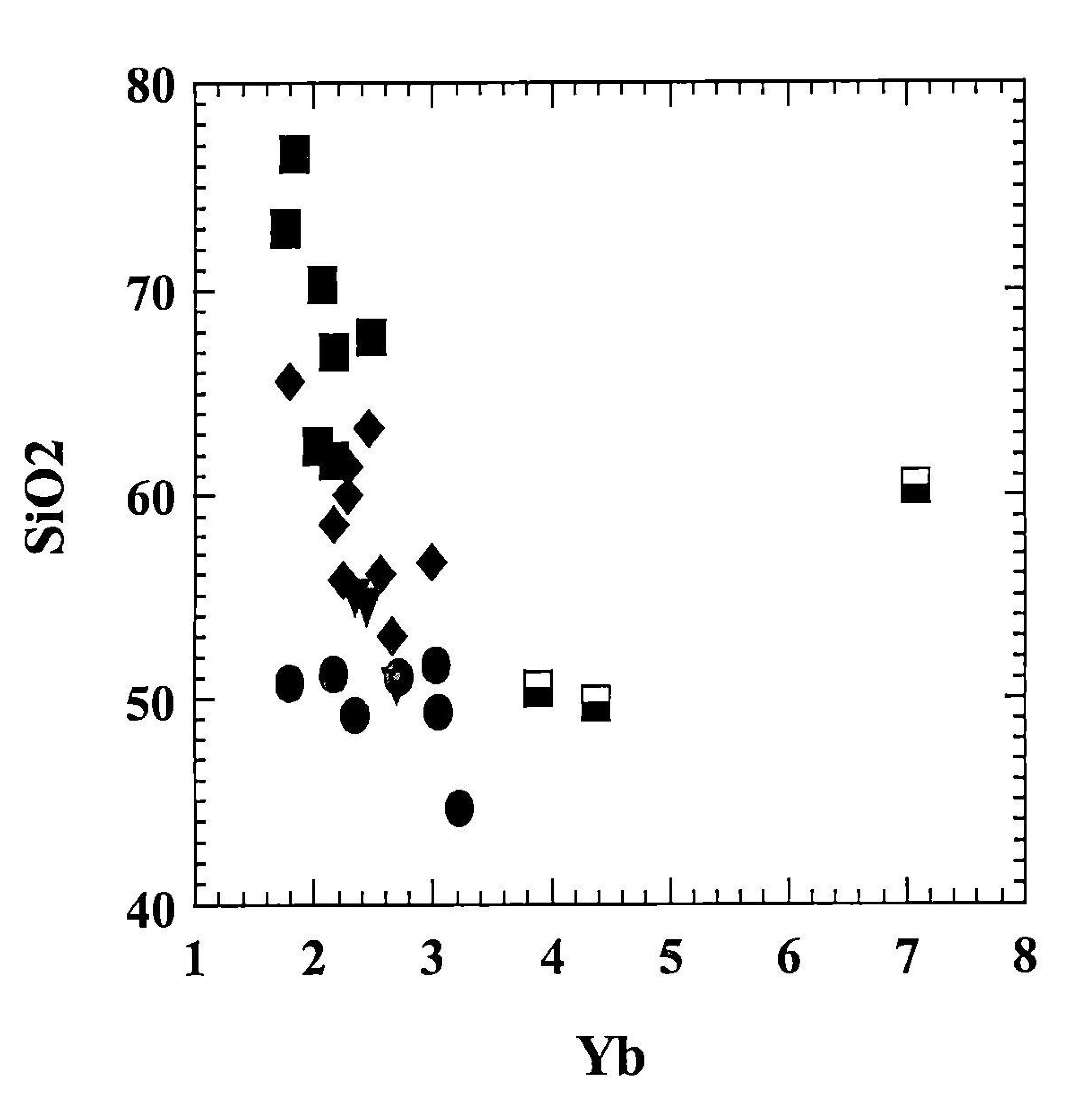
This section summarizes recently acquired ICPMS REE data from BGS Keyworth using a range of REE and trace element plots. Analyses from the Southern Highland Group and Tayvallich/Loch Avich lavas (Figures 18–24) are mainly from the Aberfoyle-Loch Lomond, Loch Fyne and Tayvallich-Loch Avich areas and form part of the analytical programme outlined in section 5.1. The whole Dalradian dataset (summarised in (Figure 25)) is primarily from a traverse broadly following the A9 road and forms part of a BGS Dalradian Nd isotope traverse which also includes precision U-Pb zircon work. This work is preliminary and at an early stage but has identified common model age sources throughout the Dalradian of 1.9 Ga (Rhimis of Islay provenance) and a younger Grenvillian source.
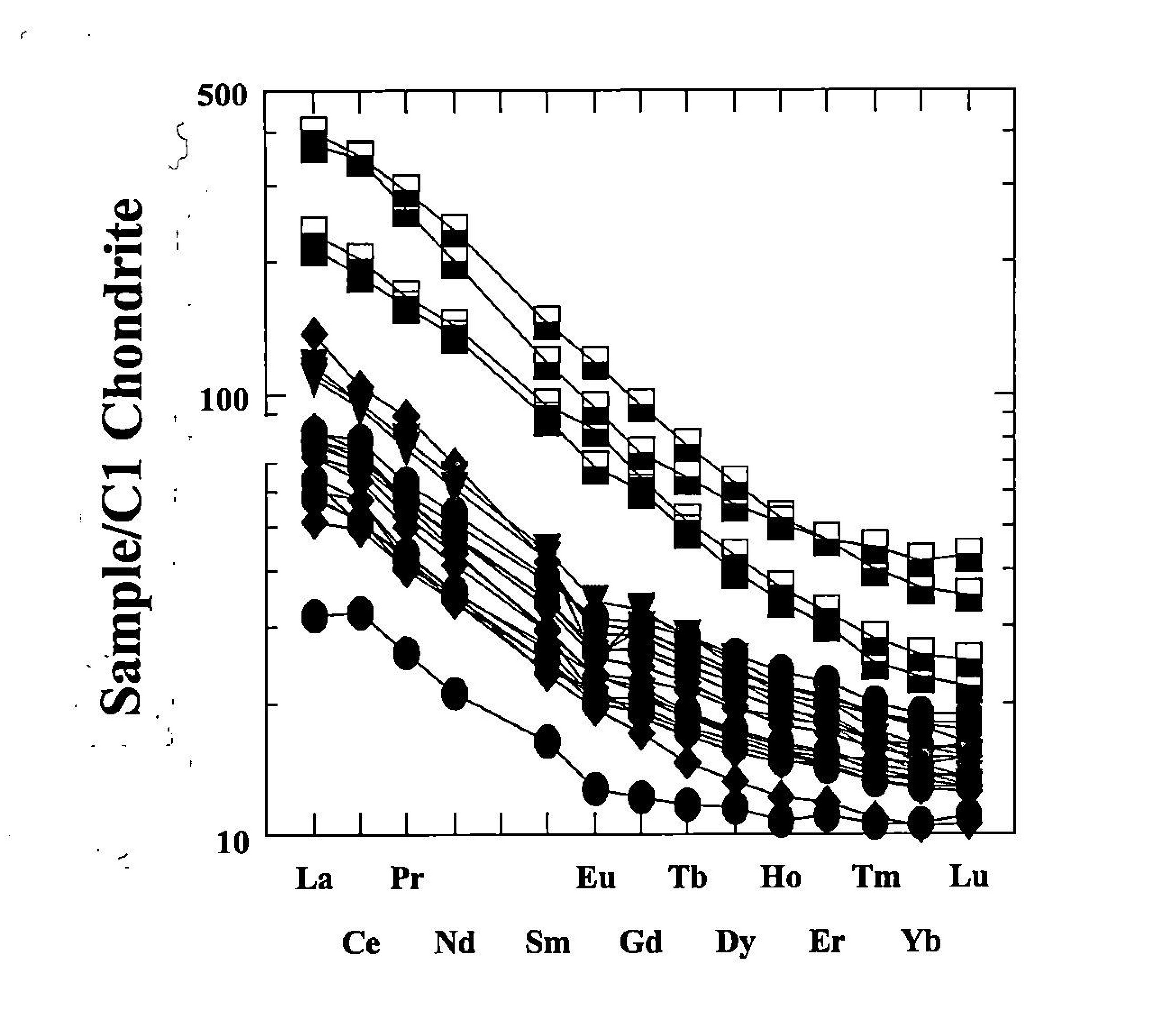
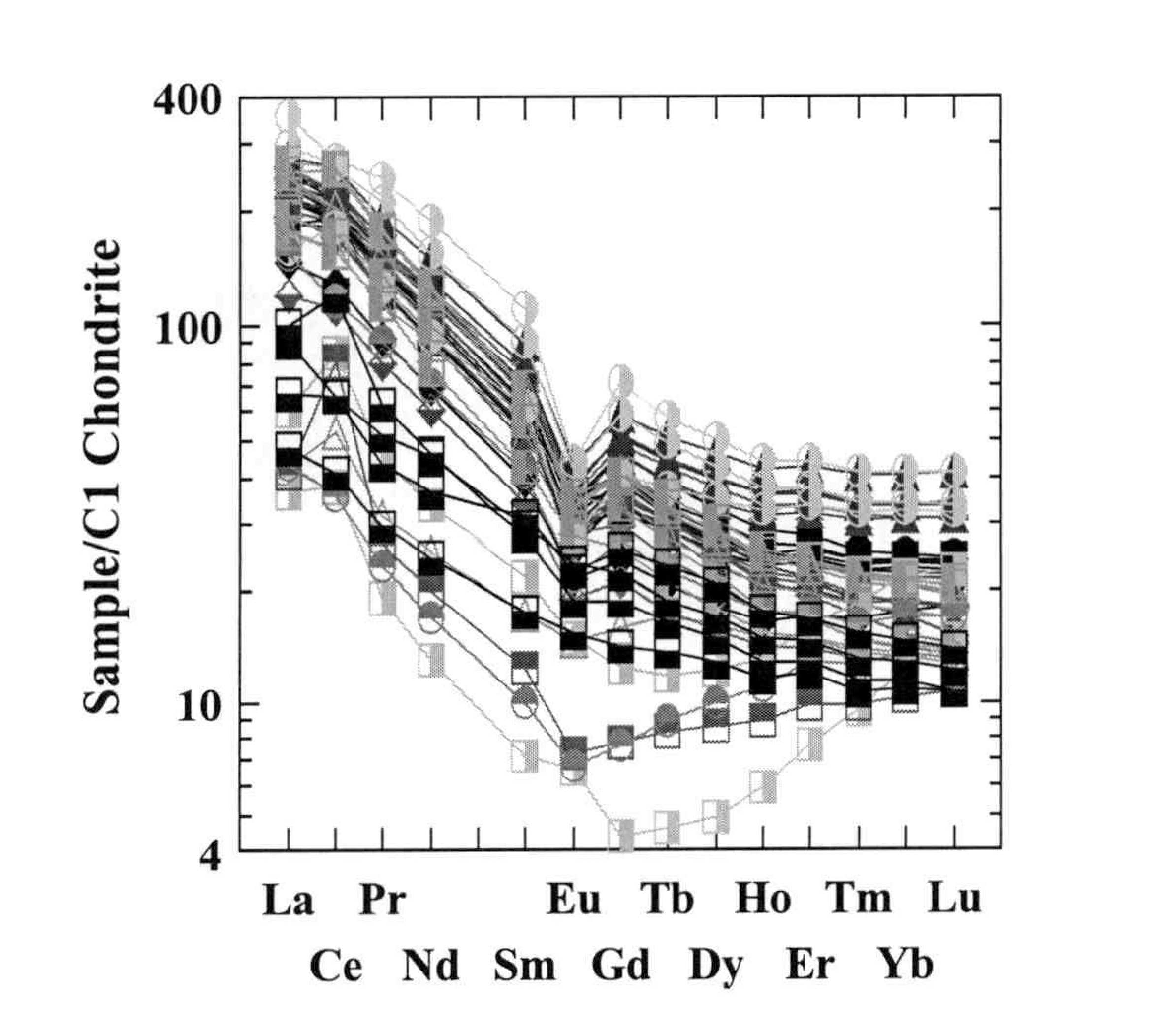
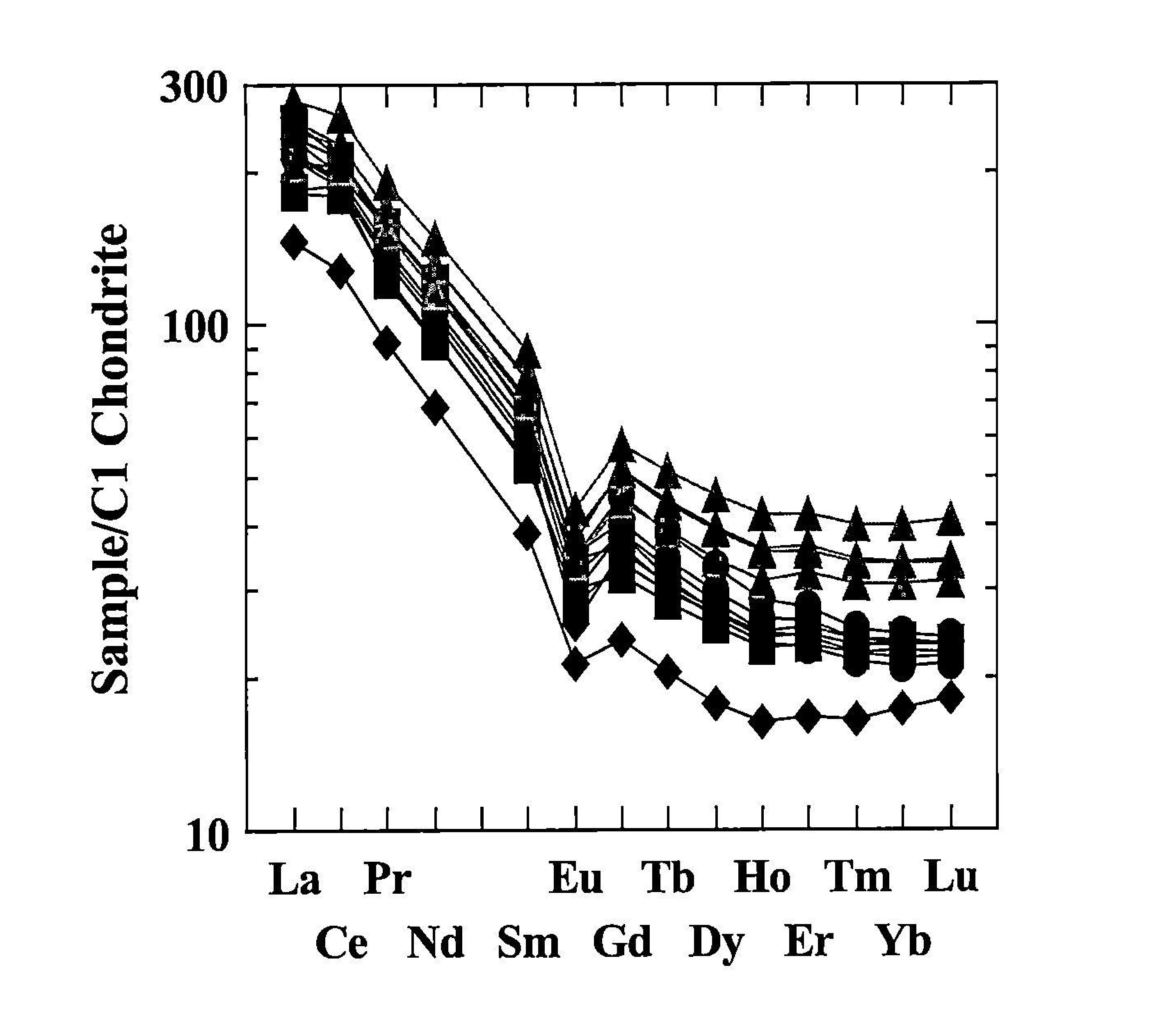
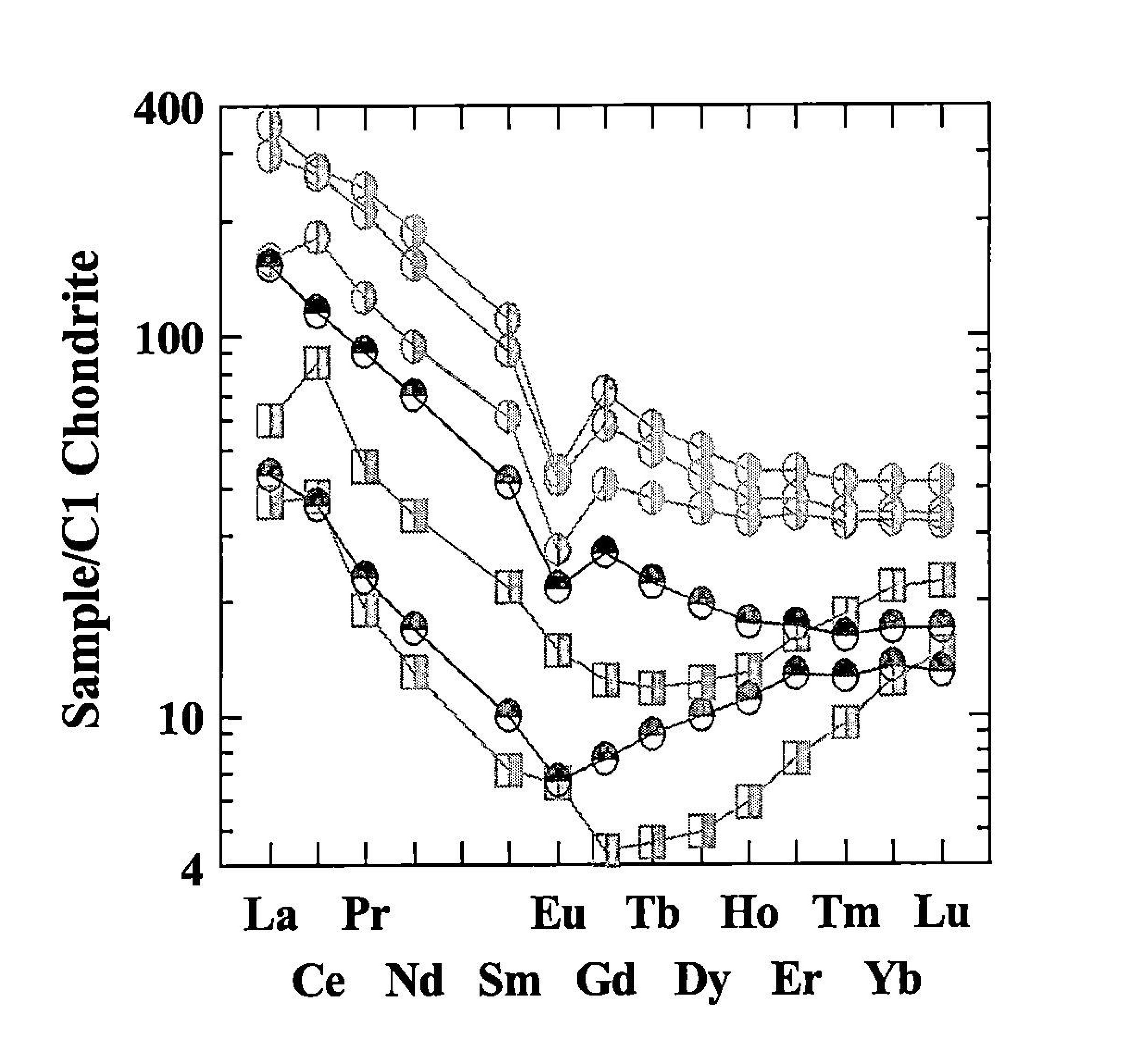
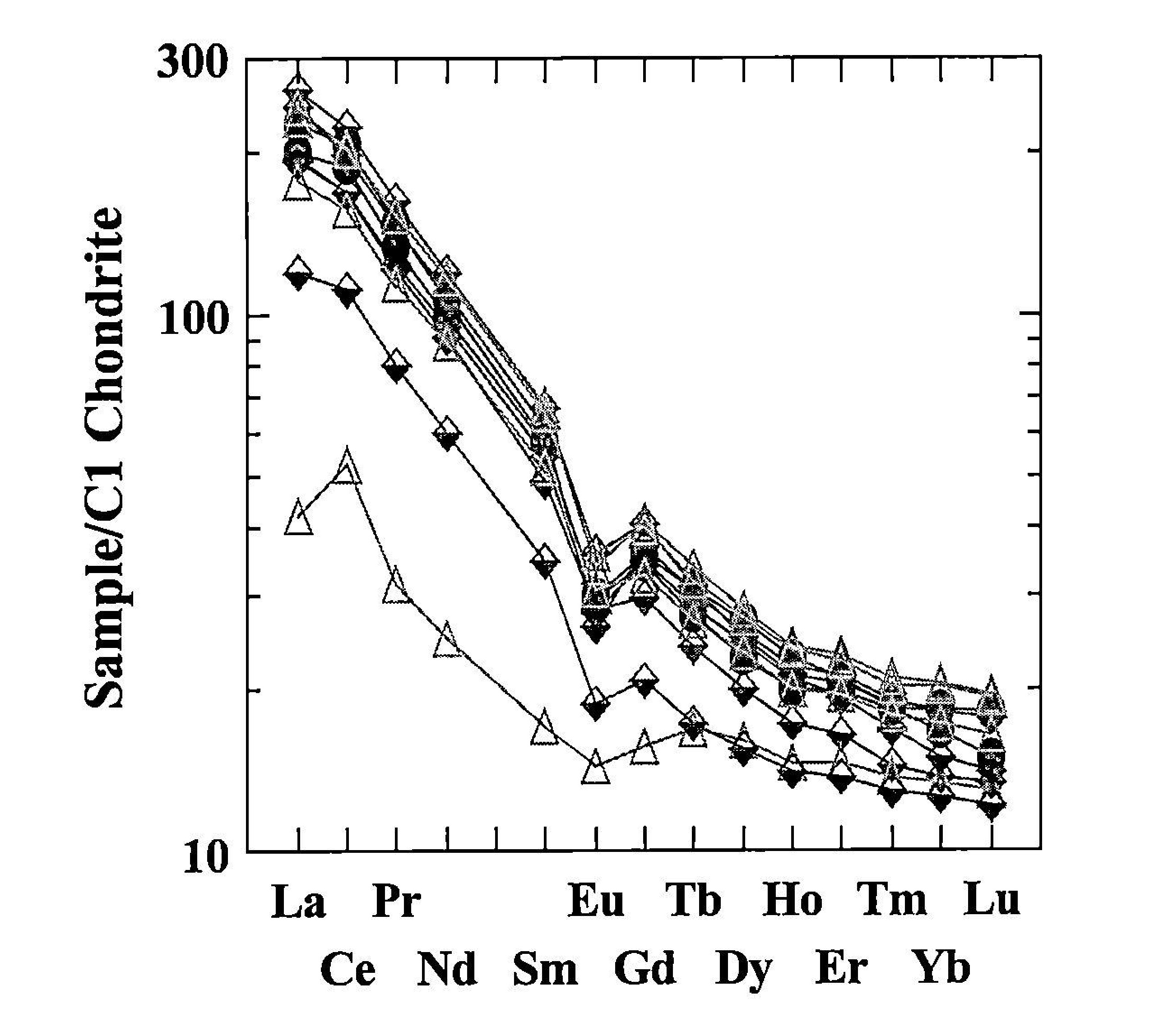
(Figure 18) summarizes chondrite-normalised REE patterns for the Green Beds, Tayvallich lavas, Loch Avich lavas and 'background' Southern Highland Group metasediments. (Figure 19), (Figure 20), (Figure 21), present data from the individual subgroups.
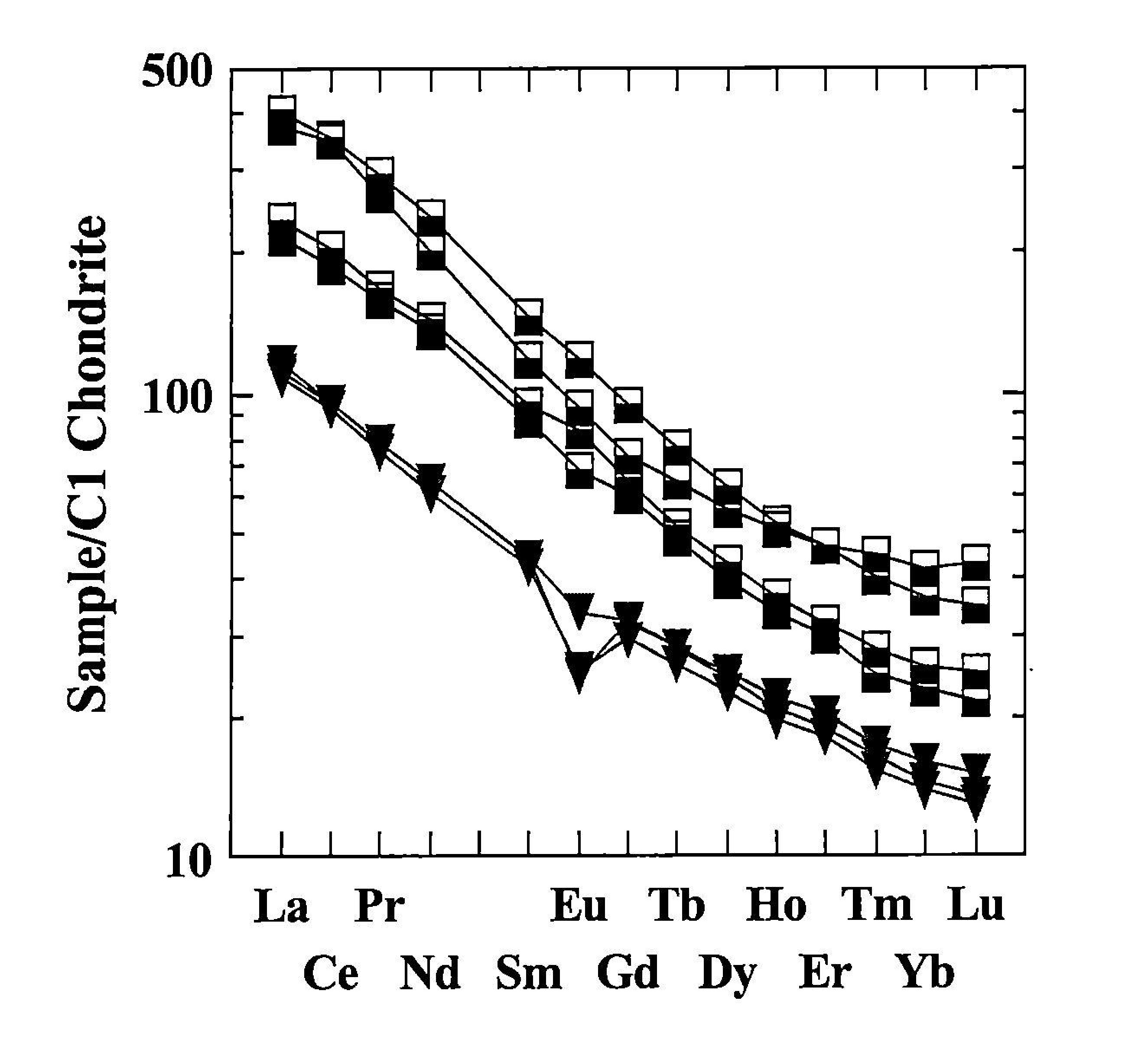
The Tayvallich lavas and hyaloclastites (Figure 18), (Figure 19) are the most enriched in REE with LREE levels around 400× chondrite. REE profiles are relatively smooth with only a relatively gentle flattening between Er and Lu. Normalised LREE/HREE ratios vary between c. 8 and 10, LREE/MREE ratios between 3 and 5, and MREE/HREE ratios of c. 1 to 2. The general REE enrichment and steep REE profiles are suggestive of a plume-influenced, ocean island basalt type source, which places the Tayvallich data within the enriched end of an Iceland plume array with respect to Nb/Y vs. Zr/Y data (Figure 24); see also (Figure 17).
The Loch Avich lavas (Figure 18), (Figure 19) mimic the less enriched Tayvallich lava REE profiles with respect to the overall shape of the REE pattern, having similar LREE/HREE ratios etc. The overall REE concentrations are reduced, being c. 100× chondrite for the LREE and c. 15× chondrite for the HREE. Two samples display negative Eu anomalies implying feldspar control. If anything, the Loch Avich lavas are slightly less enriched in LREE when compared with the Tayvallich lavas. (Figure 24) shows that the Loch Avich lavas are much less enriched in Nb relative to the Tayvallich lavas and straddle the N-MORB/Iceland plume compositional fields.
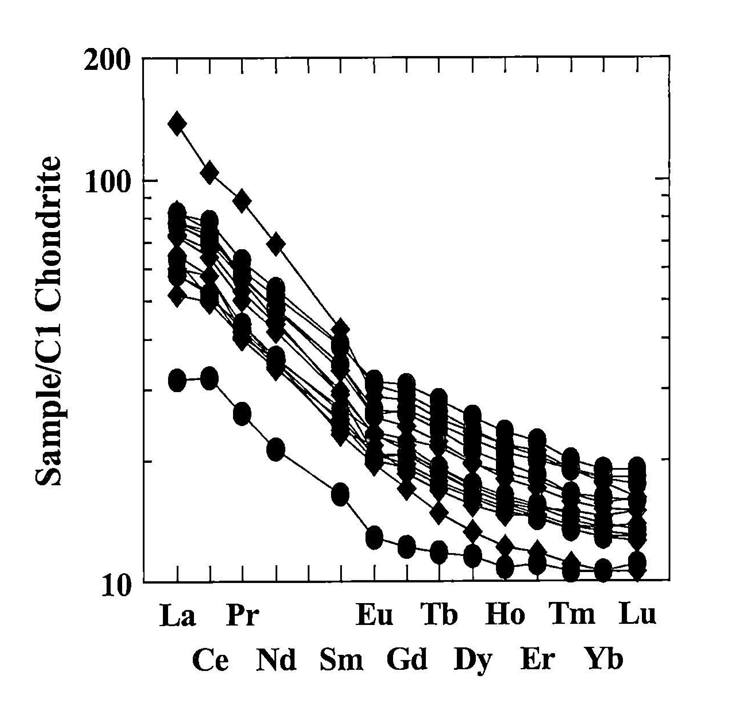
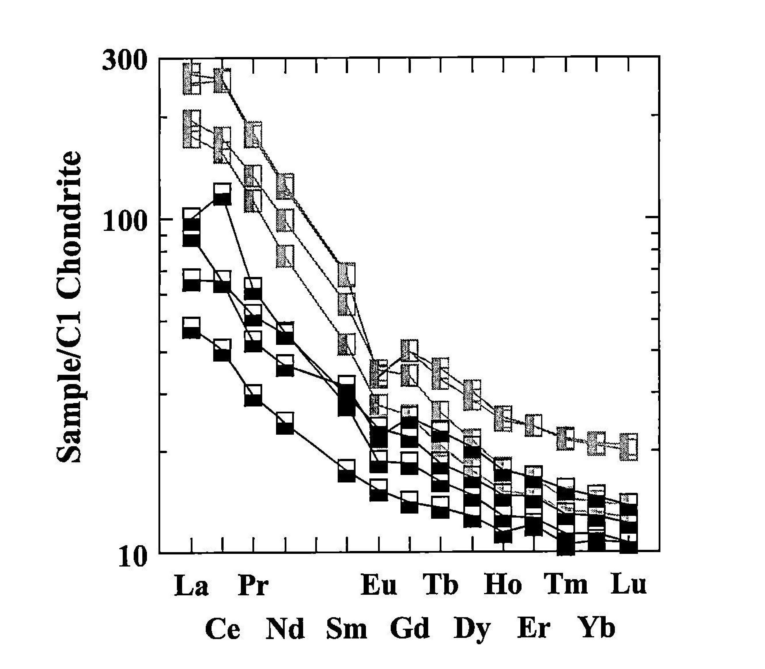
The Green Beds are subdivided into low SiO2 (<52%) and high SiO2 (52–63%) suites. (Figure 18) and (Figure 20) show that all Green Bed samples have similar REE profiles, enriched in LREE, with steep LREE/HREE gradients and flatter MREE/HREE gradients. LREE/HREE ratios are around 4, with LREE/HREE ratios between 2 and 3 and MREE/HREE ratios of c. 2. LREE and HREE concentrations vary between c. 30× to 100× chondrite and 10× to 20× chondrite respectively. The overall LREE enriched REE profile of the Green Beds suggests that plume-influenced basalts comprise a major to very significant provenance material.
'Background' Southern Highland Group metasedimentary rocks (Figure 18) and (Figure 21) are semi-pelitic to psammitic in composition with steep LREE enriched profiles. LREE and HREE concentrations vary between 100× to 200× and 10× to 17× chondrite respectively. LREE/HREE ratios are c. 10 to 12, LREE/MREE ratios around 5.5 to >7, and MREE/HREE ratios of between 2 and 3.
(Figure 22), (Figure 23), (Figure 24)
present a variety of bimodal elemental data and ratio data which suggest that the Green Beds can be interpreted as a geochemical mix between two end member compositions (see also section 5.2.3). One end member is a Dalradian siliciclastic source and the other a plume-influenced basaltic source. Interestingly, neither the Tayvallich or Loch Avich lavas are contenders for the igneous end members; Tayvallich lavas are too enriched, with high concentrations of REE and Nb, and the Loch Avich lavas plot within the compositional field of the Green Beds. Basalts from Northern Ireland are possible contenders for a basaltic end member. The Nb/Y vs. Zr/Y plot (Figure 24) depicts a broad triangular shaped compositional field for the Green Beds with the triangle apex crudely pointing towards Dalradian siliciclastic sediments (as a possible SiO2-rich end member) and the base of the triangle within the Iceland plume compositional field, indicating rock suites such as the Jura dykes as contenders for a suitable basaltic end member composition.
For comparison, a range of REE data from various groups and subgroups within the whole Dalradian are presented ((Figure 25), (Figure 26), (Figure 27), (Figure 28), (Figure 29)). What is remarkable is that the typical Dalradian semi-pelite has REE patterns similar in shape to that described above for the Southern Highland Group. LREE and HREE concentrations varies between 150× and 400× chondrite and 10× to 20× chondrite respectively, and the general pattern is characterised by steep LREE/MREE gradients and flatter MREE/HREE gradients. Many semi-pelites display negative Eu anomalies implying feldspar control within their respective provenance materials. Although there are broad similarities throughout the Dalradian there are differences and evolutionary trends when the data is looked at in detail. What is particularly heartening about this observation is that geochemical composition is correlating extremely well with mapped lithological and facies units. For example, within the Grampian Group (Figure 26) there is a temporal increase in REE concentration with time indicating that increasingly LREE enriched rocks were being gradually unroofed within the catchment area of the Grampian Group sedimentary basin. The Lochaber Group rocks (Figure 27) are the most enriched in REE with a very flat MREE to HREE profile. Argyll Group rocks (Figure 28) have the steepest REE patterns and the highest LREE/HREE ratios. The Green Beds (Figure 29) stand out from the spread of Dalradian sediment REE data, indicating that a basaltic provenance source is required to explain their unusual composition.
6. Acknowledgements
We would like to thank all the participants of the field excursion for stimulating discussions.
British Geological Survey: Doug Fettes, John Mendum, Mike Petterson, Chris Thomas, Alice Wain
University of Edinburgh: Godfrey Fitton, Martin Howard
In particular we would like to acknowledge Mike Petterson and Godfrey Fitton for their contribution to the geochemistry.
Geological Survey of Northern Ireland: Mark Cooper Terry Johnston
University of Kingston: Elaine Burt 7.
References
Allison, A. 1941. Loch Awe succession and tectonics: Kilmartin–Tayvallich–Danna. Quarterly Journal of the Geological Society of London, 96, 423–449.
Anderton, R. 1985. Sedimentation and tectonics in the Scottish Dalradian. Scottish Journal of Geology, 21, 407–436.
Borradaile, G J. 1973. Dalradian structure and stratigraphy of the northern Loch Awe district, Argyllshire. Transactions of the Royal Society of Edinburgh, 69, 1–21.
Borradaile, G J. 1977. The Dalradian rocks of the northern Loch Awe district. Scottish Journal of Geology, 13, 155–164.
Cox, K G, Bell, J D, and Pankhurst, R J. 1979. The interpretation of igneous rocks. George, Allen and Unwin, London.
Elles, G L. 1935. The Loch na Cille Boulder Bed and its place in the Highland succession. Quarterly Journal of the Geological Society of London, 91, 111–149.
Fitton, J G, Saunders, A D, Norry, M J, Hardarson, B S, and Taylor, R N. 1997. Thermal and chemical structure of the Iceland Plume. Earth and Planetary Science Letters, 153, 197–208.
Geological Survey of Northern Ireland. 1997. Northern Ireland. Solid Geology (second edition). 1: 250 000. (Keyworth, Nottingham: British Geological Survey.)
Goodman, S, and Winchester, J A. 1993. Geochemical variations within metavolcanic rocks of the Dalradian Farragon Beds and adjacent formations. Scottish Journal of Geology, 29, 131–141.
Gower, P J. 1977. The Dalradian rocks of the west coast of the Tayvallich peninsula. Scottish Journal of Geology, 13, 125–133.
Graham, C M. 1976. Petrochemistry and tectonic significance of Dalradian metabasaltic rocks of the SW Scottish Highlands. Journal of the Geological Society of London, 132, 61–84.
Graham, C M, and Borradaile, G J. 1984. The petrology and structure of Dalradian metabasaltic dykes of Jura: implications for early Dalradian evolution. Scottish Journal of Geology, 20, 257–270.
Graham, C M, and Bradbury, H J. 1981. Cambrian and late Precambrian basaltic igneous activity in the Scottish Dalradian: a review. Geological Magazine, 118, 27–37.
Halliday, A N, Graham, C M, Aftalion, M, and Dymoke, P. 1989. The depositional age of the Dalradian Supergroup: U-Pb and Sm-Nd isotopic studies of the Tayvallich Volcanics, Scotland. Journal of the Geological Society of London, 146, 3–6.
Harris, A L, and Fettes, D J. 1972. Stratigraphy and structure of Upper Dalradian rocks at the Highland Border. Scottish Journal of Geology, 12, 253–264.
Hyslop, E K, and Pickett, E A. 1998. A preliminary study of the petrology of the Green Beds and associated rocks from the Southern Highland Group of the Scottish Dalradian. British Geological Survey, Technical Report WG/98/7.
Hyslop, E K, and Pickett, E A. 1999. Green Beds and related metabasic rocks in the Dalradian Supergroup of Northern Ireland: a petrographic and geochemical approach. British Geological Survey, Technical Report WA/99/18C.
McPhie, J, Doyle, M, and Allen, R. 1993. Volcanic textures: a guide to the interpretation of textures in volcanic rocks. University of Tasmania, Centre for ore deposit and exploration studies.
Peach, B N, Wilson, J S G, Hill, J B, Bailey, E B, and Grabham, G W. 1911. The geology of Knapdale, Jura and North Kintyre. Memoir of the Geological Survey of the United Kingdom.
Pearce, J A, and Norry, M J. 1979. Petrogenetic implications of Ti, Zr, Y and Nb variations in volcanic rocks. Contributions to Mineralogy and Petrology, 69, 33–47.
Pickett, E A. 1997. An introduction to the Green Beds of the Southern Highland Group of the Scottish Dalradian: previous research and an account of preliminary work carried out in 1997. British Geological Survey, Technical Report WA/97/92.
Roberts, J L. 1977. The Dalradian rocks of Knapdale and North Kintyre. Scottish Journal of Geology, 13, 113–124.
Shervais, J W. 1982. Ti-V plots and the petrogenesis of modern and ophiolitic lavas. Earth and Planetary Science Letters, 72, 54–64.
Soper, N J. 1994. Was Scotland a Vendian RRR triple junction? Journal of the Geological Society of London, 151, 579–582
Stephenson, D, and Gould, D. 1995. British regional geology: the Grampian Highlands (4th edition). (London: HMSO for the British Geological Survey.)
Winchester, J A, and Floyd, P A. 1977. Geochemical discrimination of different magma series and their differentiation products using immobile elements. Chemical Geology, 20, 325–343.
Wood, D S. 1964. Some structures in the Dalradian pillow lavas of the Tayvallich Peninsula, Argyll. Geological Magazine, 101, 481–487.
List of figures
(Figure 1) (a) Dalradian outcrop in Scotland showing distribution of Appin, Argyll and Southern Highland Groups. (b) Dalradian rocks in the SW Highlands showing the subgroups of the Argyll Group.
(Figure 2) Summary of the stratigraphy of the upper Dalradian of the S and SW Scottish Highlands and Northern Ireland, showing formations examined in this study.
(Figure 3) Geological map of Knapdale and North Kintyre from Roberts (1977) (after BGS sheets 28 (Jura) and 29 (Rothesay)). Localities 1 and 2 from (Figure 4) (Tarbert excursion) are also shown.
(Figure 4) Geological map of the section between Barmore Island and Tarbert (from Roberts 1977), showing localities for Green Beds (locality 1) and Beinn Bheula schist (locality 2). (b) Sedimentary log through the Green Beds at locality 1 (from Pickett 1997).
(Figure 5) Thin sections of Tarbert Green Beds. Top: Green Bed composed of fine grained epidote (dark granular) and chlorite (small elongate laths), with quartz and feldspar (white). Blocky biotite ('b') and ilmenite ('P) grow across the fabric. (BGS sample S3276; plane polarized light, image 4 mm across). Bottom: Schistose Green Bed with deformed elongate quartz clasts ('q'), highly elongate blue-green hornblende ('h', arrowed), and large oblique biotite growing across the main fabric. Groundmass is a mixture of finer grained chlorite and epidote, with occasional euhedral apatite ('a'). (BGS sample S55361; plane polarized light, image 1 mm across).
(Figure 6) Location map of the Tayvallich Peninsula showing locality sites.
(Figure 7) Possible models for the formation of the Tayvallich Volcanic Formation showing contemporaneous volcanic facies that develop in association with the emplacement of submarine lava flows (top) and domes (bottom). From McPhie et al. (1993).
(Figure 8) Stratigraphic facies log through the Tayvallich volcanic rocks and underlying limestone at Port nan Clach Cruinn (excursion locality 6). From Gower (1977).
(Figure 9) Distribution of the principal lithologies of the Dalradian rocks in the northern Loch Awe district. From Borradaile (1977).
(Figure 10) Geological map of the Kilmelford/Loch Phearsain district showing excursion localities from the text. After Borradaile (1977).
(Figure 11) Geological map of the ground to the NE of Loch Avich (from Borradaile 1977).
(Figure 12) Detail of part of (Figure 11) showing (a) geology of Loch Avich Lavas locality, and (b) field sketch of vesicular pillow lavas. (From Pickett 1997).
(Figure 13) Igneous classification diagrams for Green Beds from the Mull of Kintyre-Tarbert-Loch Fyne area (open circles), Tayvallich lavas (squares) and Loch Avich lavas (filled circles). (a) Zr/TiO2 –Nb/Y diagram (Winchester and Floyd 1977), (b) total alkalis — silica diagram (Cox et al. 1979).
(Figure 14) Variation diagrams. (a) MgO–SiO2 diagram, (b) Cr–TiO2 diagram.
(Figure 15) Zr/ TiO2 –Ni diagrams showing a mixing trend between sedimentary and igneous end-member compositions. Plot (a) shows data for a wide range of Scottish Dalradian suites. Plot (b) shows data for Green Beds from the Mull of Kintyre-Tarbert-Loch Fyne area (open circles) and background psammites (diamonds) in relation to data from N Ireland.
(Figure 16) Tectonic discrimination diagrams. (a) V–Ti diagram showing ocean-floor basalt as opposed to arc affinities for the Scottish Dalradian (fields after Shervais 1982), (b) Zr/Y–Zr diagram showing mid ocean ridge to within-plate affinities for the same suite of rocks (fields after Pearce and Norry 1979).
(Figure 17) Scottish Dalradian samples plotted on a Nb/Y — Zr/Y diagram showing Icelandic basalt plume and N-MORB arrays (fields after Fitton et al. 1997). Plot (a) shows a range of Scottish Dalradian suites including Green Beds (open circles). Plot (b) shows igneous suites only in relation to data from N Ireland.
(Figure 18) All data: Tayvallich lavas and hyaloclastites, Loch Avich lavas, Green Beds and Southern Highland Group 'background' metasediments.
(Figure 19) Tayvallich and Loch Avich lavas (squares — Tayvallich; triangles — Loch Avich).
(Figure 20) Low SiO2 (<52%) and High SiO2 (52–63.3%) Green Beds (circles — low SiO2; diamonds — High SiO2).
(Figure 21) 'Background' Southern Highland Group metasediments.
(Figure 22) SiO2 vs. La for Tayvallich lavas (half squares); Loch Avich lavas (triangles); Southern Highland Group metasediments (squares); high SiO2 Green Beds (diamonds) and low SiO2 Green Beds (circles).
(Figure 23) SiO2 vs. Yb, symbols as for (Figure 22).
(Figure 24) Nb/Y vs. Zr/Y Diagram for Tayvallich lavas (squares); Loch Avich lavas (pale diamonds); background SHG metasediments (dark diamonds); Green Beds (triangles pointing right); Ben Vrackie Intrusive Complex (triangles pointing down) and assorted basic dykes and intrusions from the Upper Dalradian.
(Figure 25) REE Plot for whole Dalradian.
(Figure 26) REE patterns for Basement (diamond) and Grampian Group (squares and circles Glen Shirra and Corrieyairach subgroups; triangles — Glen Spean subgroup).
(Figure 27) REE patterns for the Appin Group (squares — Blair Atholl subgroup; top filled circles — Ballachulish subgroup; right filled circles — Lochaber subgroup).
(Figure 28) REE patterns for the Argyll Group (circles — Islay (Schiehallion) subgroup; triangles — Ben Lui Schist; diamonds — Sron Beag and Ben Lawyers Schists).
(Figure 29) REE patterns for the Southern Highland Group (left filled squares — Birnam Slates and Pitlochry Schist; lower filled squares — Green Beds).

