Sewerby
D.J.A. Evans
Introduction
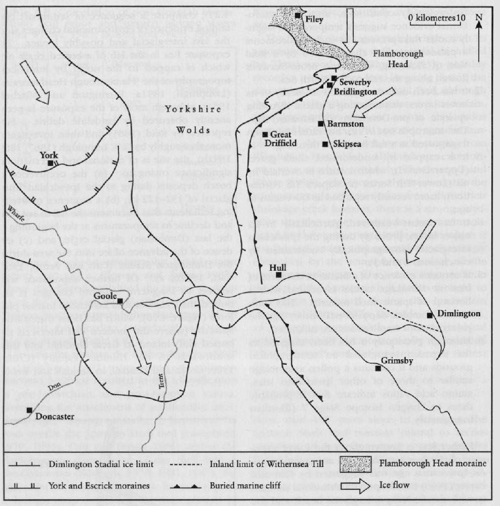
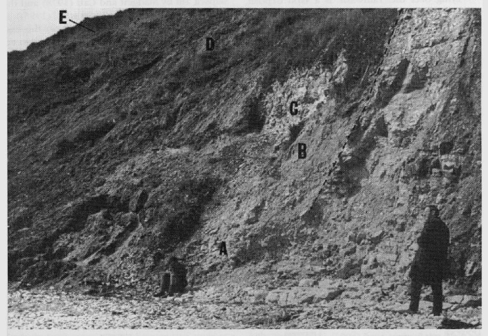
The cliffs at Sewerby, a village to the north of Bridlington on the east Yorkshire coast (Figure 4.25), comprise a sequence of sediments containing evidence of environmental changes since the last interglacial and possibly longer. The exposure lies in the lee of a buried chalk cliff, which is capped to the north by hummocky topography of the 'Flamborough Head moraine' (Lamplugh, 1891a; Farrington and Mitchell, 1951), although most of the exposure is permanently obscured by landslide debris. First reported by Reid (1885) and then investigated more thoroughly by G.W. Lamplugh (1887, 1889, 1891b), the site is of national and international significance owing to: (a) the occurrence of beach deposits dating to the Ipswichian Interglacial of 132–122 ka; (b) a sequence of overlying sediments that document the fall in sea level and decline in temperatures at the beginning of the last (Devensian) glacial cycle; and (c) evidence of the advance of ice into the area during the Dimlington Stadial (Catt and Penny, 1966; Can, 1987b, c). Of further importance with respect to long-term sea-level changes is the buried chalk cliffline and associated marine platform
Some uncertainty surrounds the stratigraphical relationship between the interglacial beach deposits and the lowest and oldest glacial deposit, the Basement
Description
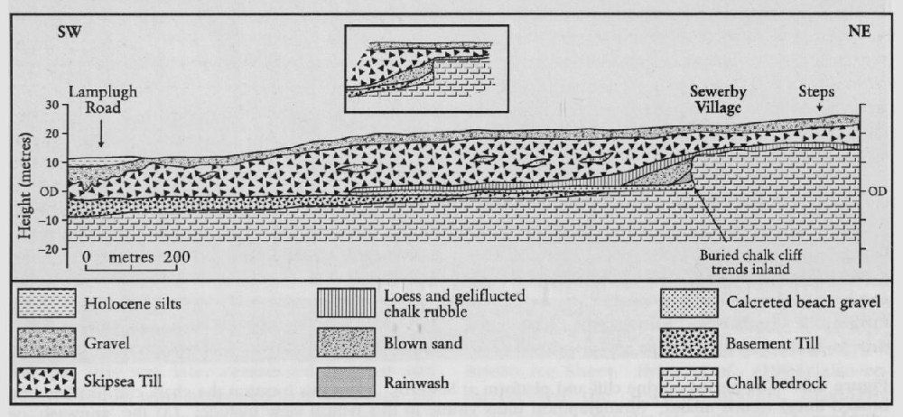
The buried marine cliff and platform at Sewerby
The complex till classification scheme that has arisen for east Yorkshire over the last century or more is reviewed in the Dimlington GCR site report (Chapter 5). The lowest and oldest till at Sewerby, the Basement
The interglacial beach at Sewerby is up to 1.5 m thick and comprises rounded chalk pebbles with occasional flints and erratic lithologies
Overlying the beach and banked up against the buried cliff base is up to 1.5 m of a clay and chalk slope deposit described as 'clayey chalk-wash' by Lamplugh (1887) and 'rainwash' by Cat and Penny (1966). This deposit includes terrestrial molluscs and vertebrate remains (
Lying over the 'rainwash' is a sand deposit, referred to as 'blown sand' by Lamplugh (1887) and Catt and Penny (1966), which occurs as a depositional wedge backed up against the buried cliff and thickens to 8 m at the cliff face. Bedding observed within the sand by Lamplugh (1887) dipped towards the cliff. Although the sand is predominantly well sorted it also includes occasional angular chalk clasts. This deposit contains a restricted vertebrate fauna
A clast-supported diamicton, comprising angular chalk and flint clasts with minor sand and silt beds and referred to as 'Chalk rubble' by Lamplugh (1887), occurs as a thin drape (<30 cm thick) on the buried cliff top and then thickens to a maximum of 6 m in a south-westerly direction beyond the former cliff line. This deposit contains cold-climate terrestrial molluscs as reported by Lamplugh (1903). The silt beds possess a similar minerological signature to silts within the overlying Drab–Skipsea
The upper and most recent till at Sewerby, the Drab
| Ipswichian beach gravel | Aeolian dune sand | ||
| Mammalia | |||
| Crocuta crocuta (hyaena) | • | • | |
| Ursus (bear) | • | ||
| Palaeoloxodon antiquus (straight-tusked elephant) | • | ||
| Didermoceros hemitoechus (narrow-nosed rhinoceras) | • | • | |
| Hippopotamus amphibius (hippopotamus) | • | ||
| Megaloceros giganteus (giant deer) | • | ||
| Bison cf. Priscus (bison) | • | • | • |
| Arvicola terrestris (water vole) | • | ||
| Mollusca | |||
| Littorina littorea L. | • | ||
| Ostrea edulis L. | • | ||
| Mytilus edulis L. | • | ||
| Purpura lapillus L. | • | ||
| Pholas sp. | • | ||
| Saxicava sp. | • | ||
| Helix hispida L. | • | ||
| Helix pulchella Mull | • | ||
| Pupa marginata Drap. | • | ||
| Zua subcyclindrica L. | • |
The stratigraphical exposure at Sewerby is capped by an extensive gravel unit comprising horizontally bedded, massive and imbricated clasts with predominantly discoid and oblate shapes (Eyles et al., 1994). Named the 'Sewerby Gravels' by Dakyns (1879, 1880), Lamplugh (1884a, 1887) and Catt and Penny (1966), this unit was observed by Lamplugh (1881a) to include freshwater silts and ice-wedge casts at a location now hidden behind the sea wall at Bridlington. Similar laminated silts and ice-wedge pseudomorphs have been reported from a coarsening upwards sequence of sediments overlying the Skipsea
Interpretation
The stratigraphical position and age of the Basement
The changing palaeoenvironmental conditions at Sewerby can be reconstructed by using the faunal remains found within the individual sedimentary units (Lamplugh, 1891b; Boylan, 1967). These are particularly valuable in the interglacial beach and the three overlying units deposited before the Skipsea
The 'rainwash' was interpreted by Lamplugh (1888) and Catt and Penny (1966) as a slope deposit produced by gradual erosion of the chalk cliff by overland flow and minor mass movement processes. The deposit has the characteristics typical of colluvium, materials deposited on slopes by a combination of runoff and mass movement. Interdigitation of the col-luvium and the beach gravels indicates that the storm beach was incorporating chalk clasts by the constant erosion of the bedrock cliff during the high sea-level stand of the last (Ipswichian) interglacial. Owing to the fact that colluvium was removed from the cliff base by storm waves during the deposition of the underlying beach gravels, the survival of the colluvium was interpreted by Lamplugh (1887) and Catt (1987c) as an early stratigraphical indicator of declining sea level. Catt (1987a) further speculated that the colluvium and overlying blown sand equates to Oxygen Isotope Stages 5d-5a.
The banking of sand up against the cliff is interpreted as further firm evidence for the fall in sea level in the region. Lamplugh (1887) suggested that the bedding within the well-sorted sand indicated a wind-blown origin and that the sediment accumulated as a dune, initially in front of the cliff and later overtopping it. Further analyses by Catt et al. (1974) verified an aeolian origin. The dominance of aeolian processes at this time is also indicated by the polished surface of the chalk cliff face, which Lamplugh (1887) interpreted as the product of sand-blasting. The age of 120 840 ± 1820 years BP reported by Bateman and Catt (1996) lends support to the suggested Ipswichian interglacial age for the underlying beach deposits.
Lamplugh's (1887) 'chalk rubble' is interpreted as a gelifluction deposit produced by slow mass movements in a periglacial climate, as indicated by the angularity of clasts and the cold-climate terrestrial molluscs (Lamplugh, 1903).
The Drab–Skipsea
For a long time regarded as the outwash from the receding Dimlington glacier margin (Lamplugh, 1884a; Catt, 1987c), the Sewerby Gravels have recently been re-interpreted as the products of coastal beach processes by Eyles et al. (1994). A marine origin was suggested originally by Lamplugh (1884a) and the reconciliation of fluvial versus marine interpretations of other sand and gravel deposits along the Yorkshire coast has remained problematic. If the Sewerby Gravels are marine beach deposits, they document a glacio-isostatically higher sea level during glacier recession. The fact that the North Sea lobe would have glacio-isostatically depressed the crust is incontrovertible, but the penetration of the sea into this area of the North Sea Basin and the flooding of depressed land surfaces during early deglaciation, when global sea levels were up to 100 m lower, has not been demonstrated by available sea-level records for the region (Lambeck, 1995). Lamplugh (1884a, 1891a) concluded that all of the evidence suggested a glaciofluvial origin for the Sewerby Gravels, probably in deltas deposited at the margins of a proglacial lake dammed on the Holderness coastal plain by the receding ice margin. This implies that the finer-grained sediments that crop out farther south are interpreted as the distal, deep-water equivalents of the Sewerby Gravels. The ice-wedge pseudomorphs that occasionally are exposed in the Sewerby Gravels possibly indicate that permafrost conditions prevailed until well after ice recession from the Yorkshire coast, although alternative interpretations of these structures are tenable (e.g. water-escape pipes). Models of sea-level changes during deglaciation have yet to verify the marine origin of the Sewerby Gravels and no systematic sedimentological investigation has been undertaken on the sediments.
The most recently revised correlation of Quaternary deposits in the British Isles (Bowen, 1999) has renamed most of the sedimentary and stratigraphical units discussed above in order to bring the nomenclature in line with standard lithostratigraphical terminology. The Basement
Conclusions
Sewerby is a site of considerable national and international value with respect to late Quaternary palaeoenvironmental reconstructions and long-term sea-level change. Specifically, the Quaternary sediments are banked up against and drape a buried marine cliff and associated platform that was cut by marine erosion during previous interglacial climate(s). A gravel beach lying on the platform and possibly overlying an older till documents a sea level slightly higher than present. The beach material and two overlying sedimentary units contain faunal remains diagnostic of the last Ipswichian interglacial, dating from 132 to 122 ka. Slope deposits and dune sands overlying the beach gravels record the fall in sea level at the close of the Ipswichian interglacial, when global sea levels were falling in response to the build-up of continental ice sheets. The onset of cold conditions during the Devensian glaciation is recorded by a gelifluction deposit, which drapes the cliff and the earlier sediments. It is thought that a depositional gap of 100 000 years exists between the deposition of the dune sand and the gelifluction deposit. The latter is truncated by the Skipsea
Further critical work is required at Sewerby on two major themes: (a) the stratigraphical position of the Basement